 |
|
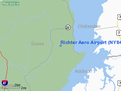
Location & QuickFacts
| FAA Information Effective: | 2008-09-25 |
| Airport Identifier: | NY84 |
| Airport Status: | Operational |
| Longitude/Latitude: | 073-22-43.4600W/44-16-45.1840N
-73.378739/44.279218 (Estimated) |
| Elevation: | 360 ft / 109.73 m (Surveyed) |
| Land: | 20 acres |
| From nearest city: | 3 nautical miles SW of Essex, NY |
| Location: | Essex County, NY |
| Magnetic Variation: | 15W (1985) |
Owner & Manager
| Ownership: | Privately owned |
| Owner: | Kenneth I. Richter |
| Address: |
Essex, NY 12936 |
| Phone number: | 518-963-7080 |
| Manager: | Kenneth I. Richter |
| Address: |
Essex, NY 12936 |
| Phone number: | 518-963-7080 |
Airport Operations and Facilities
| Airport Use: | Private |
| Wind indicator: | Yes |
| Segmented Circle: | No |
| Control Tower: | No |
| Lighting Schedule: | PHONE REQ
FOR RWY LGTS & ROTG BCN CALL 518-963-7080. |
| Beacon Color: | Clear-Green (lighted land airport) |
| Landing fee charge: | No |
| Sectional chart: | Montreal |
| Region: | AEA - Eastern |
| Boundary ARTCC: | ZBW - Boston |
| Tie-in FSS: | BTV - Burlington |
| FSS on Airport: | No |
| FSS Toll Free: | 1-800-WX-BRIEF |
Airport Communications
Airport Services
| Airframe Repair: | NONE |
| Power Plant Repair: | NONE |
Runway Information
Runway 02/20
| Dimension: | 2200 x 60 ft / 670.6 x 18.3 m |
| Surface: | TURF, |
| Edge Lights: | Low |
| |
Runway 02 |
Runway 20 |
| Traffic Pattern: | Left | Left |
| Obstruction: | 1000 ft hills, 5000.0 ft from runway | |
|
Radio Navigation Aids
| ID |
Type |
Name |
Ch |
Freq |
Var |
Dist |
| MPV | FAN MARKER | Brook | | | | 31.2 nm |
| R | FAN MARKER | Chitt | | | 14W | 42.4 nm |
| VKN | NDB | Mount Mansfield | | 268.00 | 16W | 30.2 nm |
| JRV | NDB | Morrisville/stowe | | 375.00 | 16W | 38.4 nm |
| DYO | NDB | Smuto | | 221.00 | 15W | 39.0 nm |
| SLK | VOR/DME | Saranac Lake | 029X | 109.20 | 14W | 36.1 nm |
| MPV | VOR/DME | Montpelier | 045X | 110.80 | 16W | 41.7 nm |
| RUT | VOR/DME | Rutland | 47X | 111.00 | 15W | 48.9 nm |
| BTV | VORTAC | Burlington | 122X | 117.50 | 15W | 11.0 nm |
| PLB | VORTAC | Plattsburgh | 116X | 116.90 | 15W | 25.2 nm |
| BTV | VOT | Burlington Intl | | 109.00 | | 15.0 nm |
Remarks
Images and information placed above are from
http://www.airport-data.com/airport/NY84/
We thank them for the data!
| General Info
|
| Country |
United States
|
| State |
NEW YORK
|
| FAA ID |
NY84
|
| Latitude |
44-16-45.184N
|
| Longitude |
073-22-43.460W
|
| Elevation |
360 feet
|
| Near City |
ESSEX
|
We don't guarantee the information is fresh and accurate. The data may
be wrong or outdated.
For more up-to-date information please refer to other sources.
|
|


