 |
|
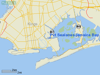
Pvt Sealanes-jamaica Bay Seaplane Base Airport |
Location & QuickFacts
| FAA Information Effective: | 2008-09-25 |
| Airport Identifier: | NK30 |
| Airport Status: | Operational |
| Longitude/Latitude: | 073-54-08.4000W/40-36-19.2000N
-73.902333/40.605333 (Estimated) |
| Elevation: | 0 ft / 0.00 m (Estimated) |
| Land: | 0 acres |
| From nearest city: | 0 nautical miles W of Brooklyn, NY |
| Location: | Queens County, NY |
| Magnetic Variation: | 13W (1985) |
Owner & Manager
| Ownership: | Privately owned |
| Owner: | Domenick Landriscina |
| Address: | 2620 National Drive
Brooklyn, NY 11234 |
| Phone number: | 917-696-2622 |
| Manager: | Domenick Landriscina |
| Address: | 2620 National Drive
Brooklyn, NY 11234 |
| Phone number: | 917-696-2622 |
Airport Operations and Facilities
| Airport Use: | Private |
| Wind indicator: | No |
| Segmented Circle: | No |
| Control Tower: | No |
| Landing fee charge: | No |
| Sectional chart: | New York |
| Region: | AEA - Eastern |
| Boundary ARTCC: | ZNY - New York |
| Tie-in FSS: | ISP - New York |
| FSS on Airport: | No |
| FSS Toll Free: | 1-800-WX-BRIEF |
Runway Information
Runway 08W/26W
| Dimension: | 5000 x 500 ft / 1524.0 x 152.4 m |
| Surface: | WATER, |
| |
Runway 08W |
Runway 26W |
| Traffic Pattern: | Left | Left |
|
Runway 17W/35W
| Dimension: | 5000 x 500 ft / 1524.0 x 152.4 m |
| Surface: | WATER, |
| |
Runway 17W |
Runway 35W |
| Traffic Pattern: | Left | Left |
|
Radio Navigation Aids
| ID |
Type |
Name |
Ch |
Freq |
Var |
Dist |
| EWR | FAN MARKER | Maryann | | | 11W | 14.3 nm |
| OGY | NDB | Bridge | | 414.00 | 12W | 2.4 nm |
| PNJ | NDB | Paterson | | 347.00 | 12W | 23.4 nm |
| BBN | NDB | Babylon | | 275.00 | 14W | 24.0 nm |
| CAT | NDB | Chatham | | 254.00 | 11W | 25.4 nm |
| NEL | NDB | Lakehurst | | 396.00 | 13W | 39.1 nm |
| OP | NDB | Old Field Point Light | | 316.00 | 13W | 42.1 nm |
| NEL | TACAN | Lakehurst | 055X | | 11W | 39.9 nm |
| NEL | UHF/NDB | Lakehurst | | 274.80 | 13W | 39.1 nm |
| CRI | VOR/DME | Canarsie | 070X | 112.30 | 11W | 0.6 nm |
| JFK | VOR/DME | Kennedy | 106X | 115.90 | 12W | 6.2 nm |
| LGA | VOR/DME | La Guardia | 078X | 113.10 | 12W | 11.0 nm |
| TEB | VOR/DME | Teterboro | 021X | 108.40 | 11W | 16.3 nm |
| COL | VOR/DME | Colts Neck | 101X | 115.40 | 11W | 21.2 nm |
| DPK | VOR/DME | Deer Park | 124X | 117.70 | 12W | 29.5 nm |
| SBJ | VOR/DME | Solberg | 076X | 112.90 | 10W | 38.3 nm |
| CMK | VOR/DME | Carmel | 113X | 116.60 | 12W | 43.1 nm |
| BWZ | VOR/DME | Broadway | 089X | 114.20 | 11W | 43.5 nm |
| BDR | VOR/DME | Bridgeport | 25X | 108.80 | 12W | 48.6 nm |
| STW | VOR/DME | Stillwater | 033X | 109.60 | 11W | 49.9 nm |
| RBV | VORTAC | Robbinsville | 085X | 113.80 | 10W | 36.4 nm |
| SAX | VORTAC | Sparta | 104X | 115.70 | 11W | 40.1 nm |
| GXU | VORTAC | Mc Guire | 043X | 110.60 | 11W | 47.9 nm |
| JFK | VOT | Kennedy | | 115.10 | | 5.9 nm |
| ISP | VOT | Long Island Mac Arthur | | 109.40 | | 38.4 nm |
| BDR | VOT | Bridgeport | | 109.25 | | 48.6 nm |
Remarks
- PRVDD OPNS ARE CONDUCTED IN ACCORD WITH: VFR & TCA REQMTS. OPNS ARE CONDUCTED SO AS TO REMAIN WELL CLEAR OF POLICE DEPT & CG OPNS AT FLOYD BENNETT; & OPNS DEPG & ARRG JFK; SPCLY THOSE UTILIZING THE CANARSIE SIAP. OPNS ARE CONDUCTED NOT ABOVE 500' ASL. SEALANES ARE FOR PRIVATE USE ONLY. SEALANES ARE*
Images and information placed above are from
http://www.airport-data.com/airport/NK30/
We thank them for the data!
| General Info
|
| Country |
United States
|
| State |
NEW YORK
|
| FAA ID |
NK30
|
| Latitude |
40-33-20.380N
|
| Longitude |
073-53-08.489W
|
| Elevation |
0 feet
|
| Near City |
BROOKLYN
|
We don't guarantee the information is fresh and accurate. The data may
be wrong or outdated.
For more up-to-date information please refer to other sources.
|
|


