|
|
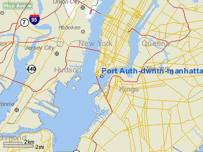
Port Auth-dwntn-manhattan/wall St Heliport |
| Downtown Manhattan Heliport |
 |
| IATA: JRB – ICAO: KJRB – FAA LID: JRB |
| Summary |
| Airport type |
Public |
| Owner |
NYCEDC |
| Operator |
Saker Aviation Services |
| Serves |
New York City |
| Elevation AMSL |
7 ft / 2 m |
| Coordinates |
40°42′04″N 74°00′32″W / 40.701116°N 74.008801°W / 40.701116; -74.008801Coordinates: 40°42′04″N 74°00′32″W / 40.701116°N 74.008801°W / 40.701116; -74.008801 |
| Website |
www.downtownmanhattanheliport.com |
| Helipads |
| Number |
Length |
Surface |
| ft |
m |
| H1 |
62 |
19 |
Concrete |
| Statistics (2003) |
| Aircraft operations |
10,002 |
| Source: FAA and official site |
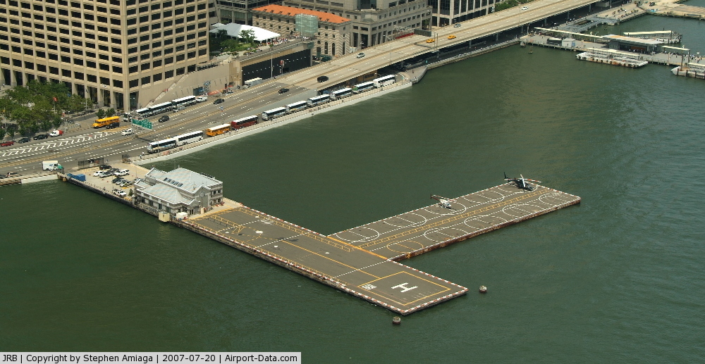
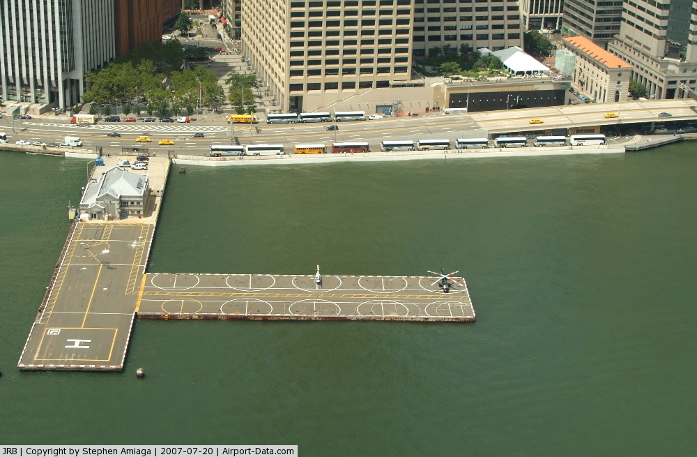
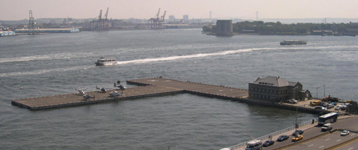
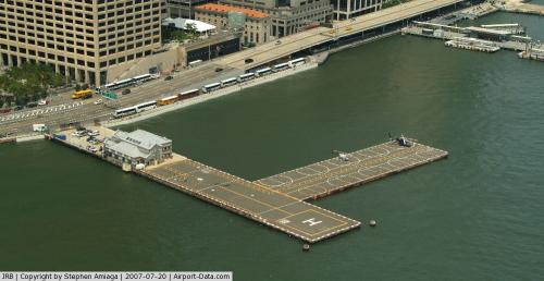
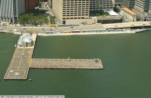
The landing pad as seen from the East River 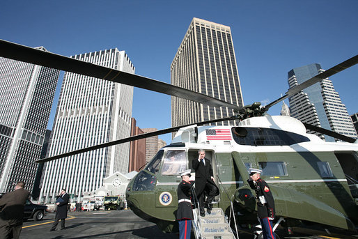 | |
George W. Bush at the heliport on January 31, 2007 |
The Downtown Manhattan Heliport (IATA: JRB, ICAO: KJRB, FAA LID: JRB), also known as the Downtown Manhattan/Wall St. Heliport, is a helicopter landing platform at Pier 6 in the East River in Manhattan, New York. History
Downtown Manhattan Heliport opened on December 8, 1960, supplementing the existing heliport at West 30th Street which opened in 1956. The Downtown Manhattan Heliport was the first heliport in the United States certified for scheduled passenger service. During the 1960s and 1970s, New York Airways provided scheduled service from the heliport to the city's major airports. Scheduled passenger service was discontinued with PanAm's bankruptcy in the mid-1980s. In 2006, US Helicopter resumed scheduled passenger service with hourly flights to John F. Kennedy International Airport.
Much of the heliport's traffic is generated by Wall Street and the lower Manhattan financial district; top business executives and time-sensitive document deliveries often use the heliport. The heliport is also the normal landing spot for the President of the United States on visits to New York. Michael Bloomberg, now mayor of New York, frequently used the heliport to fly between Bloomberg L.P. headquarters and Johns Hopkins University when he was chairman of both institutions.
The Downtown Manhattan Heliport is a public heliport operated by the New York City Economic Development Corporation (NYCEDC) with charter service to Newark Liberty International Airport, Teterboro Airport, Morristown Municipal Airport, and other New York-area airports. Public sightseeing and VIP flights are also common.
Facilities and aircraft
The heliport covers an area of 2 acres (1 ha) at an elevation of 7 feet (2 m) above mean sea level. It has one helipad designated H1 with a 62 x 62 ft (19 x 19 m) concrete surface. For the 12-month period ending December 30, 2003, the airport had 10,002 aircraft operations, an average of 27 per day: 90% general aviation and 10% military.
Airlines
- US Helicopter (Bridgeport, New York-JFK) [temporarily suspended]
The above content comes from Wikipedia and is published under free licenses – click here to read more.
 |
(Click on the photo to enlarge) |
 |
(Click on the photo to enlarge) |
Location & QuickFacts
| FAA Information Effective: | 2008-09-25 |
| Airport Identifier: | JRB |
| Airport Status: | Operational |
| Longitude/Latitude: | 074-00-32.5020W/40-42-04.3690N
-74.009028/40.701214 (Estimated) |
| Elevation: | 7 ft / 2.13 m (Estimated) |
| Land: | 2 acres |
| From nearest city: | 3 nautical miles SE of New York, NY |
| Location: | New York County, NY |
| Magnetic Variation: | 13W (1985) |
Owner & Manager
| Ownership: | Publicly owned |
| Owner: | Port Auth Of Ny & Nj |
| Address: | Pier 6, East River
New York, NY 10004 |
| Phone number: | 212-435-7303 |
| Manager: | Enrique Wegel |
| Address: | Downtown Heliport, Pier 6 East River
New York, NY 10004 |
| Phone number: | 212-435-6355 |
Airport Operations and Facilities
| Airport Use: | Open to public |
| Wind indicator: | Yes |
| Segmented Circle: | No |
| Control Tower: | No |
| Lighting Schedule: | DUSK-DAWN |
| Landing fee charge: | Yes |
| Sectional chart: | New York |
| Region: | AEA - Eastern |
| Boundary ARTCC: | ZNY - New York |
| Tie-in FSS: | ISP - New York |
| FSS on Airport: | No |
| FSS Toll Free: | 1-800-WX-BRIEF |
| NOTAMs Facility: | ISP (NOTAM-d service avaliable) |
| Federal Agreements: | NGYH |
Airport Communications
| CTAF: | 123.050 |
| Unicom: | 123.050 |
Airport Services
| Airframe Repair: | NONE |
| Power Plant Repair: | NONE |
| Bottled Oxygen: | NONE |
| Bulk Oxygen: | NONE |
Runway Information
Helipad H1
| Dimension: | 62 x 62 ft / 18.9 x 18.9 m |
| Surface: | CONC, Good Condition |
| Weight Limit: | Single wheel: 50000 lbs. |
| |
Runway H1 |
Runway |
| Traffic Pattern: | Left | Left |
| Markings: | Basic, Good Condition | , |
|
Radio Navigation Aids
| ID |
Type |
Name |
Ch |
Freq |
Var |
Dist |
| EWR | FAN MARKER | Maryann | | | 11W | 8.1 nm |
| SKU | FAN MARKER | Stanwyck | | | 12W | 49.7 nm |
| OGY | NDB | Bridge | | 414.00 | 12W | 9.9 nm |
| PNJ | NDB | Paterson | | 347.00 | 12W | 16.1 nm |
| CAT | NDB | Chatham | | 254.00 | 11W | 19.3 nm |
| BBN | NDB | Babylon | | 275.00 | 14W | 28.5 nm |
| NEL | NDB | Lakehurst | | 396.00 | 13W | 42.2 nm |
| OP | NDB | Old Field Point Light | | 316.00 | 13W | 43.8 nm |
| SW | NDB | Neely | | 335.00 | 14W | 48.2 nm |
| SKU | NDB | Stanwyck | | 261.00 | 12W | 49.7 nm |
| NEL | TACAN | Lakehurst | 055X | | 11W | 42.9 nm |
| NEL | UHF/NDB | Lakehurst | | 274.80 | 13W | 42.2 nm |
| CRI | VOR/DME | Canarsie | 070X | 112.30 | 11W | 7.5 nm |
| LGA | VOR/DME | La Guardia | 078X | 113.10 | 12W | 8.0 nm |
| TEB | VOR/DME | Teterboro | 021X | 108.40 | 11W | 9.2 nm |
| JFK | VOR/DME | Kennedy | 106X | 115.90 | 12W | 11.6 nm |
| COL | VOR/DME | Colts Neck | 101X | 115.40 | 11W | 24.4 nm |
| DPK | VOR/DME | Deer Park | 124X | 117.70 | 12W | 32.6 nm |
| SBJ | VOR/DME | Solberg | 076X | 112.90 | 10W | 34.2 nm |
| BWZ | VOR/DME | Broadway | 089X | 114.20 | 11W | 37.5 nm |
| CMK | VOR/DME | Carmel | 113X | 116.60 | 12W | 39.8 nm |
| STW | VOR/DME | Stillwater | 033X | 109.60 | 11W | 42.9 nm |
| BDR | VOR/DME | Bridgeport | 25X | 108.80 | 12W | 48.7 nm |
| ARD | VOR/DME | Yardley | 019X | 108.20 | 10W | 49.1 nm |
| SAX | VORTAC | Sparta | 104X | 115.70 | 11W | 32.6 nm |
| RBV | VORTAC | Robbinsville | 085X | 113.80 | 10W | 37.3 nm |
| GXU | VORTAC | Mc Guire | 043X | 110.60 | 11W | 49.5 nm |
| JFK | VOT | Kennedy | | 115.10 | | 11.2 nm |
| ISP | VOT | Long Island Mac Arthur | | 109.40 | | 42.0 nm |
| BDR | VOT | Bridgeport | | 109.25 | | 48.7 nm |
Remarks
- NO FLTS OR APCHS OVER FDR DRIVE; TWO-WAY RDO RQRD.
- BIRDS ON & INVOF HELIPORT.
- BOATS MAY NAVIGATE IN WATER ALONG HELIPORT PIER.
- 100 FT CRANES OPERATING NEAR USCG FERRY SLIP.
- 12 HELICOPTER PARKING SPACES WITH ADDITIONAL TRANSIENT POSITIONS AVBL. FIRE PROTECTION FOAM SYSTEM ON SITE.
Images and information placed above are from
http://www.airport-data.com/airport/JRB/
We thank them for the data!
| General Info
|
| Country |
United States
|
| State |
NEW YORK
|
| FAA ID |
JRB
|
| Latitude |
40-42-04.369N
|
| Longitude |
074-00-32.502W
|
| Elevation |
7 feet
|
| Near City |
NEW YORK
|
We don't guarantee the information is fresh and accurate. The data may
be wrong or outdated.
For more up-to-date information please refer to other sources.
|
|