|
|
| Plattsburgh International Airport |
 |
| IATA: PBG – ICAO: KPBG – FAA LID: PBG |
| Summary |
| Airport type |
Public |
| Owner |
Clinton County |
| Serves |
Plattsburgh, New York |
| Elevation AMSL |
234 ft / 71.3 m |
| Coordinates |
44°39′03″N 073°28′05″W / 44.65083°N 73.46806°W / 44.65083; -73.46806Coordinates: 44°39′03″N 073°28′05″W / 44.65083°N 73.46806°W / 44.65083; -73.46806 |
| Website |
flyplattsburgh.com |
| Runways |
| Direction |
Length |
Surface |
| ft |
m |
| 17/35 |
11,758 |
3,584 |
Concrete |
| Source: Federal Aviation Administration |
FAA diagram of Plattsburgh International Airport (PBG) Plattsburgh International Airport (IATA: PBG, ICAO: KPBG) is located at the former Plattsburgh Air Force Base in Plattsburgh, New York. The airport is owned by Clinton County. The airport's massive facilities have been upgraded to civilian aviation standards and the county fully transitioned here from Clinton County Airport as of June 2007. Passenger service began on June 18, 2007 and Clinton County Airport has been shut down since then. All airline service in Plattsburgh now goes through the airport and local business leaders and officials are currently looking to add other airlines to the airport.
Plattsburgh International was already a fully operating and profitable industrial airport with tenants including Pratt & Whitney, Bombardier, the Department of Homeland Security, Wood Group, and others. Plattsburgh Aeronautical Institute, a major new FAA approved A&P school sponsored by Clinton Community College and Champlain Valley Educational Services, which opened nearby in September of 2009. The airport facilities include a 12,000-foot (3,700 m) runway and a 12,000,000-square-foot (1,100,000 m) concrete ramp for cargo and aircraft. Plattsburgh also has no night curfews or flight restrictions and enjoys calm weather year around (97% VFR). It is also a Foreign Trade Zone and Empire Zone, making it a virtually tax free zone for many enterprises.
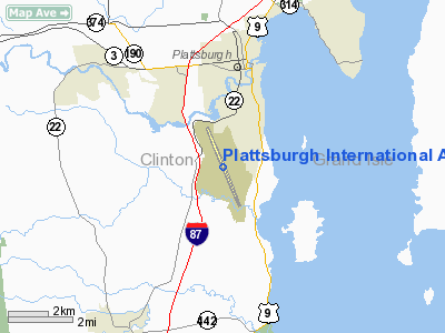
It also has significant multi-modal capabilities, including its own interchange on the Interstate Highway System (Exit 36 of I-87), a direct rail spur from the main Canadian Pacific Railway line between Montreal and New York City; a new railyard on site; and direct rail and highway access to the Port of Montreal just 60 miles (97 km) north. Plattsburgh International has been attempting to promote itself as "Montreal's U.S. Airport," standing just one hour from downtown Montreal.
On September 5, 2007, it was learned that Las Vegas-based airline, Allegiant Air, would offer non-stop flights from Plattsburgh International Airport to Fort Lauderdale-Hollywood International Airport in Fort Lauderdale, Florida. The service began on November 16, 2007. The airline has cited Plattsburgh as an ideal location due to its proximity to Montreal. Allegiant operates a similar situation with Bellingham International Airport in Bellingham, Washington, which is close to Vancouver.
On March 15, 2008, the airport began hosting regular service by Direct Air, offering three direct flights weekly to Myrtle Beach, South Carolina. The charter airline already had a successful service to Myrtle Beach from Niagara Falls, which has drawn many passengers from Ontario just as Plattsburgh is now doing from Quebec.
The airport is also served by Colgan Air, offering up to three flights daily to Boston. Airlines and destinations
| Airlines |
Destinations |
| Allegiant Air |
Fort Lauderdale, Orlando-Sanford, St. Petersburg/Clearwater |
| Direct Air operated by Xtra Airways |
Myrtle Beach [year round] Fort Myers/Punta Gorda, [seasonal] |
| US Airways Express operated by Colgan Air |
Boston |
The above content comes from Wikipedia and is published under free licenses – click here to read more.
Location & QuickFacts
| FAA Information Effective: | 2008-09-25 |
| Airport Identifier: | PBG |
| Airport Status: | Operational |
| Longitude/Latitude: | 073-28-05.3000W/44-39-03.4000N
-73.468139/44.650944 (Estimated) |
| Elevation: | 234 ft / 71.32 m (Surveyed) |
| Land: | 3874 acres |
| From nearest city: | 3 nautical miles S of Plattsburgh, NY |
| Location: | Clinton County, NY |
| Magnetic Variation: | 15W (1985) |
Owner & Manager
| Ownership: | Publicly owned |
| Owner: | Clinton County
LEASEE. PROPERTY OWNED BY U.S. AIR FORCE, AFBCA 304 NEW YORK ROAD, PLATTSBURGH, N.Y. 12903; TEL: 518-561-2871. |
| Address: | 137 Margaret St
Plattsburg, NY 12901 |
| Phone number: | 518-565- 4600 |
| Manager: | Christopher Kreig |
| Address: | 42 Airport Lane Suite 201
Plattsburgh, NY 12903 |
| Phone number: | 518-565-4794 |
Airport Operations and Facilities
| Airport Use: | Open to public |
| Wind indicator: | Yes |
| Segmented Circle: | Yes |
| Control Tower: | No |
| Lighting Schedule: | DUSK-DAWN
ACTVT HIRL RY 17/35, ALSF1 RY 17, MALSR RY 35, REIL RY 17 & TWY LGTS - CTAF. |
| Beacon Color: | Clear-Green (lighted land airport) |
| Landing fee charge: | Yes
LANDING FEE FOR GA ACFT OVER 12,500 LBS. NO LANDING FEE FOR GOVERNMENT ACFT. |
| Sectional chart: | Montreal |
| Region: | AEA - Eastern |
| Traffic Pattern Alt: | 1800 ft |
| Boundary ARTCC: | ZBW - Boston |
| Tie-in FSS: | BTV - Burlington |
| FSS on Airport: | No |
| FSS Toll Free: | 1-800-WX-BRIEF |
| NOTAMs Facility: | PBG (NOTAM-d service avaliable) |
| Certification type/date: | I A S 06/2007
PPR 24 HRS FOR UNSKED ACR OPNS WITH MORE THAN 30 PSGR SEATS. CALL AMGR AT 518-565-4794. INDEX "B" COVERAGE IS AVBL UPON REQUEST. CTC AMGR. |
Airport Communications
| CTAF: | 122.700 |
| Unicom: | 122.700 |
Airport Services
| Fuel available: | 100LLA |
| Airframe Repair: | NONE |
| Bottled Oxygen: | NONE |
Runway Information
Runway 17/35
| Dimension: | 11758 x 200 ft / 3583.8 x 61.0 m |
| Surface: | CONC, Poor Condition
SOUTH END OF RY, BETWEEN TWY "C" & AER 35, PAVEMENT SPALLING, MULTIDIRECTIONAL CRACKS, SEALANT FAILURE, AREAS OF BROKEN CONCRETE AT JOINTS & CORNERS OF SLABS. |
| Surface Treatment: | Saw-cut or plastic Grooved |
| Weight Limit: | Single wheel: 119000 lbs.
Dual wheel: 174000 lbs.
Dual tandem wheel: 510000 lbs.
Dual dual tandem wheel: 780000 lbs. |
| Edge Lights: | High |
| |
Runway 17 |
Runway 35 |
| Longitude: | 073-28-36.4113W | 073-27-34.0984W |
| Latitude: | 44-39-56.9986N | 44-38-09.7541N |
| Elevation: | 234.00 ft | 159.00 ft |
| Alignment: | 127 | 127 |
| ILS Type: | ILS
| ILS/DME |
| Traffic Pattern: | Left | Right |
| Markings: | Precision instrument, Good Condition | Precision instrument, Good Condition |
| Crossing Height: | 40.00 ft | 55.00 ft |
| VASI: | 4-light PAPI on left side | 4-light PAPI on left side |
| Visual Glide Angle: | 3.00° | 3.00° |
| Approach lights: | ALSF1
SFL OTS INDEFLY. | MALSR |
| Runway End Identifier: | Yes | |
| Centerline Lights: | No | No |
| Touchdown Lights: | No | No |
| Obstruction: | 59 ft tree, 1600.0 ft from runway, 680 ft right of centerline, 23:1 slope to clear | 72 ft tree, 1720.0 ft from runway, 220 ft left of centerline, 21:1 slope to clear |
|
Radio Navigation Aids
| ID |
Type |
Name |
Ch |
Freq |
Var |
Dist |
| MPV | FAN MARKER | Brook | | | | 40.1 nm |
| VKN | NDB | Mount Mansfield | | 268.00 | 16W | 36.8 nm |
| JRV | NDB | Morrisville/stowe | | 375.00 | 16W | 37.9 nm |
| JL | NDB | Cote St Luc | | 370.00 | 16W | 49.7 nm |
| U | NDB | Uniform | | 201.00 | 15W | 50.0 nm |
| SLK | VOR/DME | Saranac Lake | 029X | 109.20 | 14W | 35.4 nm |
| PLB | VORTAC | Plattsburgh | 116X | 116.90 | 15W | 3.1 nm |
| BTV | VORTAC | Burlington | 122X | 117.50 | 15W | 19.6 nm |
| YJN | VORTAC | St Jean | 105X | 115.80 | 16W | 36.9 nm |
| BTV | VOT | Burlington Intl | | 109.00 | | 17.6 nm |
Remarks
- DRG PERIODS OF SNOW REMOVAL OPNS NOV 1-MAY 1 ACFT CTC 122.7 OR 518-561-4015/4016 15 MINUTES PRIOR TO LDG.
- EXPECT DOWNDRAFTS & TURBULENCE DURING PERIODS OF STRONG CROSSWINDS.
- PROVDD LETTER OF AGREEMENT WITH CLINTON COUNTY ARPT REGARDING TRAFFIC FLOWS.
Images and information placed above are from
http://www.airport-data.com/airport/PBG/
We thank them for the data!
| General Info
|
| Country |
United States
|
| State |
NEW YORK
|
| FAA ID |
PBG
|
| Latitude |
44-39-03.390N
|
| Longitude |
073-28-05.256W
|
| Elevation |
235 feet
|
| Near City |
PLATTSBURGH
|
We don't guarantee the information is fresh and accurate. The data may
be wrong or outdated.
For more up-to-date information please refer to other sources.
|
|