 |
|
Penn Yan Airport
Penn Yan - Yates County Airport |
| IATA: none – ICAO: KPEO – FAA LID: PEO |
| Summary |
| Airport type |
Public |
| Owner |
Yates County |
| Serves |
Penn Yan, New York |
| Elevation AMSL |
990 ft / 302 m |
| Coordinates |
42°38′14″N 077°03′10″W / 42.63722°N 77.05278°W / 42.63722; -77.05278 |
| Runways |
| Direction |
Length |
Surface |
| ft |
m |
| 1/19 |
5,500 |
1,676 |
Asphalt |
| 10/28 |
3,561 |
1,085 |
Asphalt |
| Statistics (2006) |
| Aircraft operations |
21,200 |
| Based aircraft |
37 |
| Source: Federal Aviation Administration |
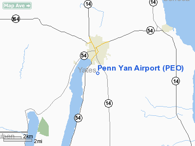
Penn Yan Airport (ICAO: KPEO, FAA LID: PEO) is a county-owned public-use airport located one nautical mile (1.8 km) south of the central business district of the Penn Yan, a village in Yates County, New York, United States. It is also known as Penn Yan - Yates County Airport.
Although most U.S. airports use the same three-letter location identifier for the FAA and IATA, this airport is assigned PEO by the FAA but has no designation from the IATA.
Facilities and aircraft
Penn Yan Airport covers an area of 315 acres (127 ha) at an elevation of 990 feet (302 m) above mean sea level. It has two asphalt paved runways: 1/19 is 5,500 by 100 feet (1,676 x 30 m) and 10/28 is 3,561 by 50 feet (1,085 x 15 m).
For the 12-month period ending June 23, 2006, the airport had 21,200 aircraft operations, an average of 58 per day: 76% general aviation and 24% air taxi. At that time there were 37 aircraft based at this airport: 81% single-engine, 5% multi-engine and 14% jet.
The above content comes from Wikipedia and is published under free licenses – click here to read more.
Location & QuickFacts
| FAA Information Effective: | 2008-09-25 |
| Airport Identifier: | PEO |
| Airport Status: | Operational |
| Longitude/Latitude: | 077-03-10.2880W/42-38-13.5180N
-77.052858/42.637088 (Estimated) |
| Elevation: | 990 ft / 301.75 m (Estimated) |
| Land: | 315 acres |
| From nearest city: | 1 nautical miles S of Penn Yan, NY |
| Location: | Yates County, NY |
| Magnetic Variation: | 12W (1995) |
Owner & Manager
| Ownership: | Publicly owned |
| Owner: | Yates County |
| Address: | County Building
Penn Yan, NY 14527 |
| Phone number: | 315-536-5150 |
| Manager: | Rich Leppert |
| Address: | 2262 Airport Dr.
Penn Yan, NY 14527 |
| Phone number: | 315-536-4471 |
Airport Operations and Facilities
| Airport Use: | Open to public |
| Wind indicator: | Yes |
| Segmented Circle: | No |
| Control Tower: | No |
| Lighting Schedule: | DUSK DAWN
ACTVT MIRL RY 01/19 - CTAF. RWY 10/28 LIRL ON DUSK-DAWN. |
| Beacon Color: | Clear-Green (lighted land airport) |
| Landing fee charge: | No |
| Sectional chart: | Detroit |
| Region: | AEA - Eastern |
| Traffic Pattern Alt: | 800 ft |
| Boundary ARTCC: | ZOB - Cleveland |
| Responsible ARTCC: | ZNY - New York |
| Tie-in FSS: | BUF - Buffalo |
| FSS on Airport: | No |
| FSS Toll Free: | 1-800-WX-BRIEF |
| NOTAMs Facility: | PEO (NOTAM-d service avaliable) |
| Federal Agreements: | NGY |
Airport Communications
| CTAF: | 123.000 |
| Unicom: | 123.000 |
Airport Services
| Fuel available: | 100LLA |
| Airframe Repair: | MAJOR |
| Power Plant Repair: | MAJOR |
| Bottled Oxygen: | NONE |
| Bulk Oxygen: | LOW |
Runway Information
Runway 01/19
| Dimension: | 5500 x 100 ft / 1676.4 x 30.5 m |
| Surface: | ASPH, Good Condition |
| Weight Limit: | Single wheel: 45000 lbs.
Dual wheel: 60000 lbs. |
| Edge Lights: | Medium |
| |
Runway 01 |
Runway 19 |
| Longitude: | 077-03-05.6900W | 077-03-09.6861W |
| Latitude: | 42-37-33.1000N | 42-38-27.3384N |
| Elevation: | 990.00 ft | 916.00 ft |
| Alignment: | 127 | 127 |
| Traffic Pattern: | Left | Left |
| Markings: | Non-precision instrument, Good Condition | Non-precision instrument, Good Condition |
| VASI: | 2-light PAPI on left side | 2-light PAPI on left side |
| Runway End Identifier: | Yes | Yes |
| Obstruction: | , 50:1 slope to clear | 44 ft tree, 2056.0 ft from runway, 394 ft left of centerline, 42:1 slope to clear |
|
Runway 10/28
| Dimension: | 3561 x 50 ft / 1085.4 x 15.2 m |
| Surface: | ASPH, Good Condition |
| Weight Limit: | Single wheel: 12000 lbs. |
| Edge Lights: | Low |
| |
Runway 10 |
Runway 28 |
| Longitude: | 077-03-38.1172W | 077-02-50.4899W |
| Latitude: | 42-38-33.6333N | 42-38-34.5011N |
| Elevation: | 845.00 ft | 903.00 ft |
| Alignment: | 88 | 127 |
| Traffic Pattern: | Left | Left |
| Markings: | Non-precision instrument, Good Condition | Non-precision instrument, Good Condition |
| Displaced threshold: | 361.00 ft | 384.00 ft |
| Runway End Identifier: | No | No |
| Centerline Lights: | No | No |
| Touchdown Lights: | No | No |
| Obstruction: | 15 ft road, 210.0 ft from runway
RWY 10 RY 10 APCH RATIO 37:1 TO DSPLCD THLD.
+28' BLDG 1' FM RY END 102'L. | 8 ft berm, 200.0 ft from runway
RWY 28 RY 28 APCH RATIO 50:1 TO DSPLCD THLD.
RWY 28 +60'TREE 170'FM RWY END 145'L |
|
Radio Navigation Aids
| ID |
Type |
Name |
Ch |
Freq |
Var |
Dist |
| PYA | NDB | Penn Yan | | 260.00 | 12W | 0.4 nm |
| ALP | NDB | Alpine | | 245.00 | 12W | 27.2 nm |
| AVN | NDB | Avon | | 344.00 | 09W | 38.7 nm |
| EL | NDB | Halos | | 269.00 | 09W | 49.7 nm |
| ITH | VOR/DME | Ithaca | 055X | 111.80 | 10W | 27.6 nm |
| GEE | VOR/DME | Geneseo | 019X | 108.20 | 09W | 32.3 nm |
| ULW | VOR/DME | Elmira | 033Y | 109.65 | 12W | 32.7 nm |
| ROC | VORTAC | Rochester | 037X | 110.00 | 09W | 39.9 nm |
| SYR | VORTAC | Syracuse | 117X | 117.00 | 11W | 48.8 nm |
| CFB | VORTAC | Binghamton | 059X | 112.20 | 10W | 49.9 nm |
Remarks
- ADF APCH RWY 10/28 TRANSITIONARY AT 700'.
- EXISTED PRIOR TO 1959
Images and information placed above are from
http://www.airport-data.com/airport/PEO/
We thank them for the data!
| General Info
|
| Country |
United States
|
| State |
NEW YORK
|
| FAA ID |
PEO
|
| Latitude |
42-38-17.900N
|
| Longitude |
077-03-10.800W
|
| Elevation |
976 feet
|
| Near City |
PENN YAN
|
We don't guarantee the information is fresh and accurate. The data may
be wrong or outdated.
For more up-to-date information please refer to other sources.
|
|


