 |
|
| Oswego County Airport |
| IATA: none – ICAO: KFZY – FAA LID: FZY |
| Summary |
| Airport type |
Public |
| Owner |
Oswego County Admin. |
| Serves |
Fulton, Oswego County, New York |
| Location |
Volney, New York |
| Elevation AMSL |
475 ft / 145 m |
| Coordinates |
43°21′03″N 076°23′17″W / 43.35083°N 76.38806°W / 43.35083; -76.38806 |
| Website |
co.oswego.ny.us/... |
| Runways |
| Direction |
Length |
Surface |
| ft |
m |
| 6/24 |
3,996 |
1,218 |
Asphalt |
| 15/33 |
5,197 |
1,584 |
Asphalt |
| Statistics (2009) |
| Aircraft operations |
20,550 |
| Based aircraft |
68 |
| Source: Federal Aviation Administration |
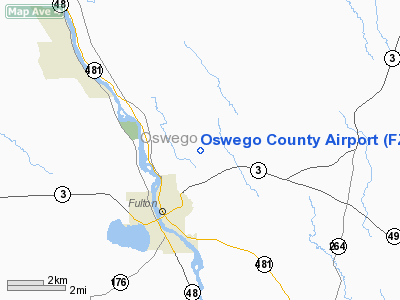
Oswego County Airport (ICAO: KFZY, FAA LID: FZY) is a county-owned, public-use airport three nautical miles (6 km) northeast of the central business district of Fulton, in Oswego County, New York, United States. The airport is located in Volney, New York. It has been designated by the Federal Aviation Administration as a general aviation reliever airport for Syracuse Hancock International Airport, located 25 miles (40 km) to the southeast.
The airport is home to a flight school and also has charter services available for local residents. Short and long-term tie-downs, as well as hangar rentals, are available to aircraft owners. Organizations based at the airport include an Experimental Aircraft Association chapter and a Civil Air Patrol squadron. In 1999, Phish performed their summer festival, Camp Oswego, at the airport.
Although most U.S. airports use the same three-letter location identifier for the FAA and IATA, this airport is assigned FZY by the FAA but has no designation from the IATA.
Facilities and aircraft
Oswego County Airport covers an area of 171 acres (69 ha) at an elevation of 475 feet (145 m) above mean sea level. It has two asphalt paved runways: 6/24 is 3,996 by 100 feet (1,218 x 30 m) and 15/33 is 5,197 by 100 feet (1,584 x 30 m).
For the 12-month period ending October 8, 2009, the airport had 20,550 aircraft operations, an average of 56 per day: 97% general aviation, 2% air taxi, and 1% military. At that time there were 68 aircraft based at this airport: 93% single-engine, 4% multi-engine, 1% jet and 1% ultralight.
The above content comes from Wikipedia and is published under free licenses – click here to read more.
Location & QuickFacts
| FAA Information Effective: | 2008-09-25 |
| Airport Identifier: | FZY |
| Airport Status: | Operational |
| Longitude/Latitude: | 076-23-16.9930W/43-21-02.7910N
-76.388054/43.350775 (Estimated) |
| Elevation: | 475 ft / 144.78 m (Surveyed) |
| Land: | 171 acres |
| From nearest city: | 3 nautical miles NE of Fulton, NY |
| Location: | Oswego County, NY |
| Magnetic Variation: | 13W (2000) |
Owner & Manager
| Ownership: | Publicly owned |
| Owner: | Oswego County Admin |
| Address: | 40 Airport Drive, 46 E. Bridge Street, Oswego, 13126
Fulton, NY 13069 |
| Phone number: | 315-591- 9130 |
| Manager: | Bruce Bisbo |
| Address: | Cr 176
Fulton, NY 13069 |
| Phone number: | 315-668-7261 |
Airport Operations and Facilities
| Airport Use: | Open to public |
| Wind indicator: | Yes |
| Segmented Circle: | No |
| Control Tower: | No |
| Lighting Schedule: | DUSK-DAWN
ACTVT MIRL RY 06/24 & REIL RYS 15 & 33 - CTAF. MIRL RY 15/33 & VASI RY 33 PRESET LOW INTST SS-SR; TO INCR INTST ACTVT - CTAF. |
| Beacon Color: | Clear-Green (lighted land airport) |
| Landing fee charge: | No |
| Sectional chart: | New York |
| Region: | AEA - Eastern |
| Boundary ARTCC: | ZBW - Boston |
| Tie-in FSS: | BUF - Buffalo |
| FSS on Airport: | No |
| FSS Toll Free: | 1-800-WX-BRIEF |
| NOTAMs Facility: | BUF (NOTAM-d service avaliable) |
| Federal Agreements: | NGY3 |
Airport Communications
| CTAF: | 123.000 |
| Unicom: | 123.000 |
Airport Services
| Fuel available: | 100LLA |
| Airframe Repair: | MAJOR |
| Power Plant Repair: | MAJOR |
| Bottled Oxygen: | NONE |
Runway Information
Runway 06/24
| Dimension: | 3996 x 100 ft / 1218.0 x 30.5 m |
| Surface: | ASPH, Good Condition |
| Surface Treatment: | Saw-cut or plastic Grooved |
| Weight Limit: | Single wheel: 30000 lbs. |
| Edge Lights: | Medium
RY 15/33 NSTD MIRL; RY 33 NO SPLIT LENSES ON LAST 2000 FT OF RY. |
| |
Runway 06 |
Runway 24 |
| Longitude: | 076-23-36.8200W | 076-22-57.3310W |
| Latitude: | 43-20-47.3390N | 43-21-14.3080N |
| Elevation: | 457.00 ft | 469.00 ft |
| Alignment: | 47 | 127 |
| Traffic Pattern: | Left | Left |
| Markings: | Non-precision instrument, Good Condition | Non-precision instrument, Good Condition |
| Runway End Identifier: | No | No |
| Centerline Lights: | No | No |
| Touchdown Lights: | No | No |
| Obstruction: | 51 ft tree, 429.0 ft from runway, 278 ft right of centerline, 4:1 slope to clear | 45 ft methane pip, 1217.0 ft from runway, 22:1 slope to clear |
|
Runway 15/33
| Dimension: | 5197 x 100 ft / 1584.0 x 30.5 m |
| Surface: | ASPH, Good Condition |
| Surface Treatment: | Saw-cut or plastic Grooved |
| Weight Limit: | Single wheel: 30000 lbs. |
| Edge Lights: | Non-standard lighting system
RY 15/33 NSTD MIRL; RY 33 NO SPLIT LENSES ON LAST 2000 FT OF RY. |
| |
Runway 15 |
Runway 33 |
| Longitude: | 076-23-40.9640W | 076-22-52.8990W |
| Latitude: | 43-21-23.0350N | 43-20-45.5650N |
| Elevation: | 447.00 ft | 475.00 ft |
| Alignment: | 127 | 127 |
| ILS Type: | | ILS/DME
|
| Traffic Pattern: | Left | Left |
| Markings: | Precision instrument, Good Condition | Precision instrument, Good Condition |
| Crossing Height: | 0.00 ft | 42.00 ft |
| VASI: | | 2-box on left side |
| Visual Glide Angle: | 0.00° | 3.25° |
| Runway End Identifier: | Yes | Yes |
| Centerline Lights: | No | No |
| Touchdown Lights: | No | No |
| Obstruction: | 48 ft trees, 201.0 ft from runway, 475 ft left of centerline
RY 15 +14 FT HILL 0-200 FT FM THLD. HILL BEGINS 295 FT LEFT. | 13 ft fence, 235.0 ft from runway, 471 ft right of centerline, 2:1 slope to clear
RY 33 +7 FT GND 0-199 FT FM THLD 335 FT RIGHT. |
|
Radio Navigation Aids
| ID |
Type |
Name |
Ch |
Freq |
Var |
Dist |
| BK | NDB | Plein | | 329.00 | 12W | 40.4 nm |
| GSS | TACAN | Griffiss | 057X | | 12W | 43.3 nm |
| SYR | VORTAC | Syracuse | 117X | 117.00 | 11W | 14.0 nm |
| ART | VORTAC | Watertown | 035X | 109.80 | 12W | 38.8 nm |
| GGT | VORTAC | Georgetown | 125X | 117.80 | 11W | 41.8 nm |
Remarks
- NO TGL OR PLA 2200-0700 DAILY.
- RY 06 DITCHES 15 FT WIDE 65 FT FM CNTRLN BOTH SIDES IN SAFETY AREA 110 FT FM THLD.
- EXISTED PRIOR TO 1959.
Images and information placed above are from
http://www.airport-data.com/airport/FZY/
We thank them for the data!
| General Info
|
| Country |
United States
|
| State |
NEW YORK
|
| FAA ID |
FZY
|
| Latitude |
43-21-02.791N
|
| Longitude |
076-23-16.993W
|
| Elevation |
475 feet
|
| Near City |
FULTON
|
We don't guarantee the information is fresh and accurate. The data may
be wrong or outdated.
For more up-to-date information please refer to other sources.
|
|


