 |
|
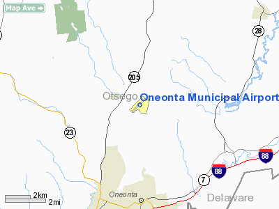
| Oneonta Municipal Airport |
| IATA: ONH – ICAO: none – FAA LID: N66 |
| Summary |
| Airport type |
Public |
| Owner |
City of Oneonta |
| Serves |
Oneonta, New York |
| Elevation AMSL |
1,763 ft / 537 m |
| Coordinates |
42°31′29″N 075°03′52″W / 42.52472°N 75.06444°W / 42.52472; -75.06444 |
| Runways |
| Direction |
Length |
Surface |
| ft |
m |
| 6/24 |
4,200 |
1,280 |
Asphalt |
| Statistics (2008) |
| Aircraft operations |
21,600 |
| Based aircraft |
9 |
| Source: Federal Aviation Administration |
Oneonta Municipal Airport (IATA: ONH, FAA LID: N66) is a public use airport located three nautical miles (6 km) north of the central business district of Oneonta, a city in Otsego County, New York, United States. The airport is owned by the City of Oneonta. It once had scheduled air service on Mohawk Airlines, formerly known as Catskill Airways.
Facilities and aircraft
Oneonta Municipal Airport covers an area of 310 acres (125 ha) at an elevation of 1,763 feet (537 m) above mean sea level. It has one runway designated 6/24 with an asphalt surface measuring 4,200 by 75 feet (1,280 x 23 m).
For the 12-month period ending February 21, 2008, the airport had 21,600 aircraft operations, an average of 59 per day: 86% general aviation, 14% air taxi, and <1% military. At that time there were 9 aircraft based at this airport: 67% single-engine, 22% multi-engine and 11% helicopter.
The above content comes from Wikipedia and is published under free licenses – click here to read more.
Location & QuickFacts
| FAA Information Effective: | 2008-09-25 |
| Airport Identifier: | N66 |
| Airport Status: | Operational |
| Longitude/Latitude: | 075-03-52.1000W/42-31-29.2000N
-75.064472/42.524778 (Estimated) |
| Elevation: | 1763 ft / 537.36 m (Surveyed) |
| Land: | 310 acres |
| From nearest city: | 3 nautical miles N of Oneonta, NY |
| Location: | Otsego County, NY |
| Magnetic Variation: | 12W (1980) |
Owner & Manager
| Ownership: | Publicly owned |
| Owner: | City Of Oneonta |
| Address: | 391 Airport Rd.
Oneonta, NY 13820 |
| Phone number: | 607-432-6465 |
| Manager: | Brad Curpier |
| Address: | 391 Airport Rd
Oneonta, NY 13820 |
| Phone number: | 607-431-1076
OR 607-431-1077. |
Airport Operations and Facilities
| Airport Use: | Open to public |
| Wind indicator: | Yes |
| Segmented Circle: | Yes
POOR CONDITION. |
| Control Tower: | No |
| Lighting Schedule: | DUSK-DAWN
ACTVT REIL RY 06/24, VASI RY 06 &PAPI 24, & MALS RY 24 - CTAF. MIRL RY 06/24 OPR SS-SR. |
| Beacon Color: | Clear-Green (lighted land airport)
BCN TWR PARTIALLY OBSCURED BY TREES. |
| Landing fee charge: | No |
| Sectional chart: | New York |
| Region: | AEA - Eastern |
| Boundary ARTCC: | ZBW - Boston |
| Tie-in FSS: | BUF - Buffalo |
| FSS on Airport: | No |
| FSS Toll Free: | 1-800-WX-BRIEF |
| NOTAMs Facility: | BUF (NOTAM-d service avaliable) |
| Federal Agreements: | NGY |
Airport Communications
| CTAF: | 122.800 |
| Unicom: | 122.800 |
Airport Services
| Fuel available: | 100LLA |
| Airframe Repair: | MAJOR |
| Power Plant Repair: | MAJOR |
| Bottled Oxygen: | NONE |
| Bulk Oxygen: | NONE |
Runway Information
Runway 06/24
| Dimension: | 4200 x 75 ft / 1280.2 x 22.9 m |
| Surface: | ASPH,
RY 06/24 LARGE AREAS LOOSE AGGREGATE, SPALLING & CRACKING. 3-4 INCH CRACKS. |
| Weight Limit: | Single wheel: 12000 lbs. |
| Edge Lights: | Medium |
| |
Runway 06 |
Runway 24 |
| Longitude: | 075-04-11.5871W | 075-03-32.5376W |
| Latitude: | 42-31-14.2766N | 42-31-44.0250N |
| Elevation: | 1763.00 ft | 1750.00 ft |
| Alignment: | 44 | 127 |
| ILS Type: | | LOCALIZER
|
| Traffic Pattern: | Left | Left |
| Markings: | Non-precision instrument, Good Condition | Non-precision instrument, Good Condition |
| Crossing Height: | 55.00 ft | 0.00 ft |
| VASI: | 4-box on right side | 2-light PAPI on left side |
| Visual Glide Angle: | 3.00° | 0.00° |
| Approach lights: | | MALS |
| Runway End Identifier: | Yes | Yes
RWY 24 REILS OTS |
| Centerline Lights: | No | No |
| Touchdown Lights: | No | No |
| Obstruction: | 32 ft tree, 968.0 ft from runway, 24:1 slope to clear
RY 06 +34 FT TREES 201 FT LEFT 0-200 FT FM THLD. | 26 ft trees, 517.0 ft from runway, 266 ft right of centerline, 12:1 slope to clear |
|
Radio Navigation Aids
| ID |
Type |
Name |
Ch |
Freq |
Var |
Dist |
| CJY | NDB | Clay | | 275.00 | 12W | 32.9 nm |
| JJH | NDB | Johnstown | | 523.00 | 14W | 43.1 nm |
| BK | NDB | Plein | | 329.00 | 12W | 45.8 nm |
| MS | NDB | Monga | | 359.00 | 12W | 46.5 nm |
| GSS | TACAN | Griffiss | 057X | | 12W | 45.2 nm |
| RKA | VOR/DME | Rockdale | 073X | 112.60 | 11W | 8.5 nm |
| DNY | VOR/DME | De Lancey | 058X | 112.10 | 11W | 21.4 nm |
| HNK | VOR/DME | Hancock | 115X | 116.80 | 11W | 29.9 nm |
| UCA | VORTAC | Utica | 049X | 111.20 | 12W | 30.5 nm |
| GGT | VORTAC | Georgetown | 125X | 117.80 | 11W | 37.3 nm |
Images and information placed above are from
http://www.airport-data.com/airport/N66/
We thank them for the data!
| General Info
|
| Country |
United States
|
| State |
NEW YORK
|
| FAA ID |
N66
|
| Latitude |
42-31-29.161N
|
| Longitude |
075-03-52.062W
|
| Elevation |
1764 feet
|
| Near City |
ONEONTA
|
We don't guarantee the information is fresh and accurate. The data may
be wrong or outdated.
For more up-to-date information please refer to other sources.
|
|


