 |
|
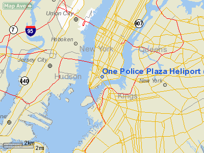
One Police Plaza Heliport |
Location & QuickFacts
| FAA Information Effective: | 2008-09-25 |
| Airport Identifier: | NK39 |
| Airport Status: | Operational |
| Longitude/Latitude: | 073-59-58.5010W/40-42-45.3680N
-73.999584/40.712602 (Estimated) |
| Elevation: | 244 ft / 74.37 m (Estimated) |
| Land: | 0 acres |
| From nearest city: | 0 nautical miles N of New York, NY |
| Location: | New York County, NY |
| Magnetic Variation: | 13W (1985) |
Owner & Manager
| Ownership: | Publicly owned |
| Owner: | City Of Ny Police Dept |
| Address: | One Police Plaza
New York, NY 10013 |
| Phone number: | 212-692-1220 |
| Manager: | Curt J Wargo
CMD AVN UNIT. |
| Address: | Hgr 4 Floyd Bennett Fld
Brooklyn, NY 11234 |
| Phone number: | 718-692-1220 |
Airport Operations and Facilities
| Airport Use: | Private |
| Wind indicator: | No |
| Segmented Circle: | No |
| Control Tower: | No |
| Lighting Schedule: | PHONE REQ
FOR PERIMETER LGTS. PHONE 212-692-1220. |
| Sectional chart: | New York |
| Region: | AEA - Eastern |
| Boundary ARTCC: | ZNY - New York |
| Tie-in FSS: | ISP - New York |
| FSS on Airport: | No |
| FSS Toll Free: | 1-800-WX-BRIEF |
Runway Information
Helipad H1
| Dimension: | 96 x 96 ft / 29.3 x 29.3 m |
| Surface: | CONC, Good Condition
HELIPAD LCTD ON ROOFTOP OF TWENTY STORY BLDG. |
| |
Runway H1 |
Runway |
| Traffic Pattern: | Left | Left |
|
Radio Navigation Aids
| ID |
Type |
Name |
Ch |
Freq |
Var |
Dist |
| EWR | FAN MARKER | Maryann | | | 11W | 8.6 nm |
| SKU | FAN MARKER | Stanwyck | | | 12W | 49.1 nm |
| OGY | NDB | Bridge | | 414.00 | 12W | 10.2 nm |
| PNJ | NDB | Paterson | | 347.00 | 12W | 15.7 nm |
| CAT | NDB | Chatham | | 254.00 | 11W | 19.7 nm |
| BBN | NDB | Babylon | | 275.00 | 14W | 28.1 nm |
| NEL | NDB | Lakehurst | | 396.00 | 13W | 43.0 nm |
| OP | NDB | Old Field Point Light | | 316.00 | 13W | 43.1 nm |
| SW | NDB | Neely | | 335.00 | 14W | 47.6 nm |
| SKU | NDB | Stanwyck | | 261.00 | 12W | 49.1 nm |
| NEL | TACAN | Lakehurst | 055X | | 11W | 43.7 nm |
| NEL | UHF/NDB | Lakehurst | | 274.80 | 13W | 43.0 nm |
| LGA | VOR/DME | La Guardia | 078X | 113.10 | 12W | 7.2 nm |
| CRI | VOR/DME | Canarsie | 070X | 112.30 | 11W | 7.7 nm |
| TEB | VOR/DME | Teterboro | 021X | 108.40 | 11W | 8.7 nm |
| JFK | VOR/DME | Kennedy | 106X | 115.90 | 12W | 11.5 nm |
| COL | VOR/DME | Colts Neck | 101X | 115.40 | 11W | 25.2 nm |
| DPK | VOR/DME | Deer Park | 124X | 117.70 | 12W | 32.0 nm |
| SBJ | VOR/DME | Solberg | 076X | 112.90 | 10W | 34.7 nm |
| BWZ | VOR/DME | Broadway | 089X | 114.20 | 11W | 37.8 nm |
| CMK | VOR/DME | Carmel | 113X | 116.60 | 12W | 39.0 nm |
| STW | VOR/DME | Stillwater | 033X | 109.60 | 11W | 43.0 nm |
| BDR | VOR/DME | Bridgeport | 25X | 108.80 | 12W | 48.0 nm |
| HUO | VOR/DME | Huguenot | 108X | 116.10 | 11W | 49.8 nm |
| ARD | VOR/DME | Yardley | 019X | 108.20 | 10W | 49.9 nm |
| SAX | VORTAC | Sparta | 104X | 115.70 | 11W | 32.5 nm |
| RBV | VORTAC | Robbinsville | 085X | 113.80 | 10W | 38.1 nm |
| JFK | VOT | Kennedy | | 115.10 | | 11.1 nm |
| ISP | VOT | Long Island Mac Arthur | | 109.40 | | 41.4 nm |
| BDR | VOT | Bridgeport | | 109.25 | | 48.0 nm |
Remarks
- NYC POLICE EMERGENCY USE ONLY.
- PRVDD OPNS ARE RSTRD TO MULTI-ENGINE HELS OR EMERG USE ONLY.
Images and information placed above are from
http://www.airport-data.com/airport/NK39/
We thank them for the data!
| General Info
|
| Country |
United States
|
| State |
NEW YORK
|
| FAA ID |
NK39
|
| Latitude |
40-42-45.368N
|
| Longitude |
073-59-58.501W
|
| Elevation |
244 feet
|
| Near City |
NEW YORK
|
We don't guarantee the information is fresh and accurate. The data may
be wrong or outdated.
For more up-to-date information please refer to other sources.
|
|


