 |
|
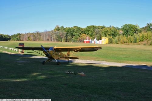 |
(Click on the photo to enlarge) |
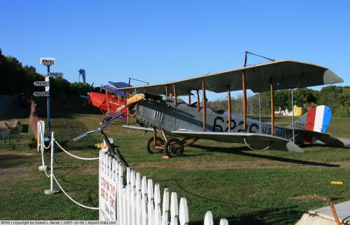 |
(Click on the photo to enlarge) |
Location & QuickFacts
| FAA Information Effective: | 2008-09-25 |
| Airport Identifier: | NY94 |
| Airport Status: | Operational |
| Longitude/Latitude: | 073-51-46.4790W/41-58-17.3310N
-73.862911/41.971481 (Estimated) |
| Elevation: | 323 ft / 98.45 m (Estimated) |
| Land: | 10 acres |
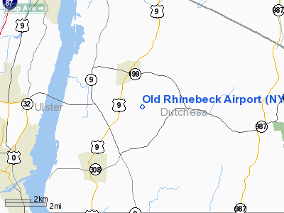
| From nearest city: | 3 nautical miles NE of Rhinebeck, NY |
| Location: | Dutchess County, NY |
| Magnetic Variation: | 13W (1985) |
Owner & Manager
| Ownership: | Privately owned |
| Address: |
|
| Manager: | James Hare |
| Address: |
|
| Phone number: | 914-758-8610 |
Airport Operations and Facilities
| Airport Use: | Private |
| Wind indicator: | Yes |
| Segmented Circle: | No |
| Control Tower: | No |
| Landing fee charge: | No |
| Sectional chart: | New York |
| Region: | AEA - Eastern |
| Boundary ARTCC: | ZBW - Boston |
| Tie-in FSS: | ISP - New York |
| FSS on Airport: | No |
| FSS Toll Free: | 1-800-WX-BRIEF |
Airport Services
| Fuel available: | 80 |
| Airframe Repair: | NONE |
| Power Plant Repair: | NONE |
Runway Information
Runway N/S
| Dimension: | 2200 x 75 ft / 670.6 x 22.9 m |
| Surface: | DIRT, |
| |
Runway N |
Runway S |
| Traffic Pattern: | Left | Left |
|
Radio Navigation Aids
| ID |
Type |
Name |
Ch |
Freq |
Var |
Dist |
| GBR | FAN MARKER | Sheffield | | | 13W | 24.2 nm |
| SKU | FAN MARKER | Stanwyck | | | 12W | 27.9 nm |
| PSF | FAN MARKER | Abyss | | | 13W | 41.0 nm |
| PFH | NDB | Philmont | | 272.00 | 13W | 18.0 nm |
| GBR | NDB | Great Barrington | | 395.00 | 14W | 24.1 nm |
| PO | NDB | Meier | | 403.00 | 12W | 24.3 nm |
| SKU | NDB | Stanwyck | | 261.00 | 12W | 27.9 nm |
| SW | NDB | Neely | | 335.00 | 14W | 33.5 nm |
| TBY | NDB | Waterbury | | 257.00 | 14W | 41.8 nm |
| DXT | NDB | Dalton | | 370.00 | 15W | 43.0 nm |
| MS | NDB | Monga | | 359.00 | 12W | 46.3 nm |
| PWL | VOR/DME | Pawling | 090X | 114.30 | 12W | 16.9 nm |
| IGN | VOR/DME | Kingston | 123X | 117.60 | 12W | 18.5 nm |
| CMK | VOR/DME | Carmel | 113X | 116.60 | 12W | 43.4 nm |
| CTR | VOR/DME | Chester | 098X | 115.10 | 13W | 45.0 nm |
| HUO | VOR/DME | Huguenot | 108X | 116.10 | 11W | 47.0 nm |
| ALB | VORTAC | Albany | 100X | 115.30 | 13W | 46.7 nm |
| ALB | VOT | Albany County | | 108.20 | | 46.4 nm |
Remarks
- AIRPORT USED FOR ANTIQUE AIR SHOWS.
- VFR USE ONLY.
Images and information placed above are from
http://www.airport-data.com/airport/NY94/
We thank them for the data!
| General Info
|
| Country |
United States
|
| State |
NEW YORK
|
| FAA ID |
NY94
|
| Latitude |
41-58-17.331N
|
| Longitude |
073-51-46.479W
|
| Elevation |
323 feet
|
| Near City |
RHINEBECK
|
We don't guarantee the information is fresh and accurate. The data may
be wrong or outdated.
For more up-to-date information please refer to other sources.
|
|


