 |
|
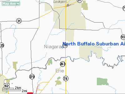
North Buffalo Suburban Airport |
Coordinates: 43°6′11″N 078°42′13″W / 43.10306°N 78.70361°W / 43.10306; -78.70361
| North Buffalo Suburban Airport |
| IATA: none – ICAO: none – FAA LID: 0G0 |
| Summary |
| Airport type |
Public |
| Owner |
Gary Leasing Inc. |
| Serves |
Lockport, New York |
| Elevation AMSL |
588 ft / 179 m |
| Runways |
| Direction |
Length |
Surface |
| ft |
m |
| 10/28 |
2,830 |
863 |
Asphalt |
| Statistics (2007) |
| Aircraft operations |
3,600 |
| Based aircraft |
31 |
| Source: Federal Aviation Administration |
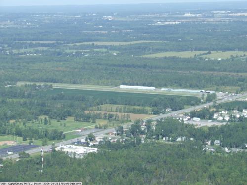
North Buffalo Suburban Airport (FAA LID: 0G0) is a public-use airport located three miles (5 km) south of the central business district of Lockport, a town in Niagara County, New York, United States. It is privately owned by Gary Leasing Inc. Facilities and aircraft
North Buffalo Suburban Airport covers an area of 90 acres (36 ha) which contains one runway designated 10/28 which measures 2,830 x 50 ft (863 x 15 m). For the 12-month period ending June 19, 2007, the airport had 3,600 general aviation aircraft operations, an average of 9 per day. There are 31 aircraft based at this airport: 97% single-engine and 3% multi-engine.
Nearby airports
KBUF - Buffalo Niagara International Airport (10 nm S)
KIAG - Niagara Falls International Airport (11 nm W)
9G3 - Akron Airport (11 nm SE)
9G0 - Buffalo Airfield (14 nm S)
9G6 - Pine Hill Airport (19 nm E)
Source: AirNav
The above content comes from Wikipedia and is published under free licenses – click here to read more.
 |
(Click on the photo to enlarge) |
Location & QuickFacts
| FAA Information Effective: | 2008-09-25 |
| Airport Identifier: | 0G0 |
| Airport Status: | Operational |
| Longitude/Latitude: | 078-42-12.0450W/43-06-11.4620N
-78.703346/43.103184 (Estimated) |
| Elevation: | 588 ft / 179.22 m (Estimated) |
| Land: | 90 acres |
| From nearest city: | 3 nautical miles S of Lockport, NY |
| Location: | Niagara County, NY |
| Magnetic Variation: | 11W (2000) |
Owner & Manager
| Ownership: | Privately owned |
| Owner: | Gary Leasing Inc. |
| Address: | 67oo Transit Road
Lockport, NY 14094 |
| Phone number: | 716-625-8111 |
| Manager: | Danny Reidy |
| Address: | 6700 Transit Road
Lockport, NY 14094 |
| Phone number: | 716-625-8111 |
Airport Operations and Facilities
| Airport Use: | Open to public |
| Wind indicator: | Yes |
| Segmented Circle: | No |
| Control Tower: | No |
| Lighting Schedule: | DUSK-DAWN
ACTIVATE MIRL RY 10/28 - 123.0. |
| Beacon Color: | Clear-Green (lighted land airport) |
| Landing fee charge: | No |
| Sectional chart: | Detroit |
| Region: | AEA - Eastern |
| Traffic Pattern Alt: | 813 ft |
| Boundary ARTCC: | ZOB - Cleveland |
| Tie-in FSS: | BUF - Buffalo |
| FSS on Airport: | No |
| FSS Toll Free: | 1-800-WX-BRIEF |
| NOTAMs Facility: | BUF (NOTAM-d service avaliable) |
| Federal Agreements: | N |
Airport Communications
| CTAF: | 123.000 |
| Unicom: | 123.000 |
Airport Services
| Fuel available: | 100LL |
| Bottled Oxygen: | NONE |
| Bulk Oxygen: | NONE |
Runway Information
Runway 10/28
| Dimension: | 2830 x 50 ft / 862.6 x 15.2 m |
| Surface: | ASPH, Fair Condition |
| Weight Limit: | Single wheel: 6000 lbs. |
| Edge Lights: | Medium
MIRL OPER LOW INTST ONLY. |
| |
Runway 10 |
Runway 28 |
| Longitude: | 078-42-31.1140W | 078-41-52.9760W |
| Latitude: | 43-06-11.7060N | 43-06-11.2180N |
| Elevation: | 588.00 ft | 588.00 ft |
| Alignment: | 91 | 127 |
| Traffic Pattern: | Left | Left |
| Markings: | Basic, Fair Condition
RY 10 MARKINGS FADED. | Basic, Fair Condition
RY 28 MARKINGS FADED. |
| Displaced threshold: | 0.00 ft | 355.00 ft |
| VASI: | | tri-color on left side |
| Visual Glide Angle: | 0.00° | 3.00° |
| Runway End Identifier: | No | No |
| Centerline Lights: | No | No |
| Touchdown Lights: | No | No |
| Obstruction: | 48 ft trees, 234.0 ft from runway, 55 ft left of centerline
RY 10 HAS +50-65 FT TREES 85-105 FT FM THLD, 60-120 FT RT. | 37 ft pline, 280.0 ft from runway, 2:1 slope to clear
APCH RATIO 17:1 TO DSPLCD THLD.
RY 28 HAS +31 FT BLDG WITH ANT, 82 FT FM RY END 38 FT L; 28 FT POLE 146 FT FM RY END 46 FT L; +31 FT POLES, 86 FT & 143 FT FM THLD, 95 FT RT; +43 FT TREE 106 FT FM RY END 157 FT RT. |
|
Radio Navigation Aids
| ID |
Type |
Name |
Ch |
Freq |
Var |
Dist |
| SN | NDB | St Catherines | | 408.00 | 01E | 24.3 nm |
| AVN | NDB | Avon | | 344.00 | 09W | 41.4 nm |
| TZ | NDB | Gibraltar Point | | 257.00 | 10W | 42.7 nm |
| L | NDB | Lima | | 368.00 | 10W | 48.2 nm |
| OO | NDB | Oshawa | | 391.00 | 10W | 49.9 nm |
| IAG | TACAN | Niagara Falls | 047X | | 10W | 11.3 nm |
| BUF | VOR/DME | Buffalo | 111X | 116.40 | 08W | 10.8 nm |
| GEE | VOR/DME | Geneseo | 019X | 108.20 | 09W | 45.6 nm |
| DKK | VORTAC | Dunkirk | 109X | 116.20 | 07W | 44.6 nm |
| ROC | VORTAC | Rochester | 037X | 110.00 | 09W | 45.2 nm |
| BUF | VOT | Buffalo | | 109.00 | | 9.9 nm |
Remarks
- RY SAFETY AREA 575 FT BY 60 FT W END RY 10.
Images and information placed above are from
http://www.airport-data.com/airport/0G0/
We thank them for the data!
| General Info
|
| Country |
United States
|
| State |
NEW YORK
|
| FAA ID |
0G0
|
| Latitude |
43-06-11.462N
|
| Longitude |
078-42-12.045W
|
| Elevation |
588 feet
|
| Near City |
LOCKPORT
|
We don't guarantee the information is fresh and accurate. The data may
be wrong or outdated.
For more up-to-date information please refer to other sources.
|
|


