 |
|
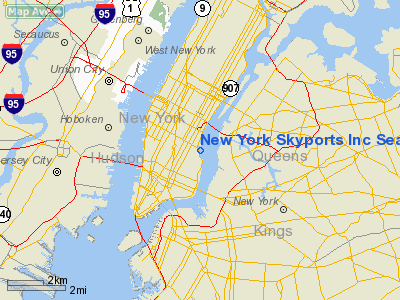
New York Skyports Inc Seaplane Base Airport |
| New York Skyports Inc. Seaplane Base |
| IATA: QNY – ICAO: none – FAA LID: 6N7 |
| Summary |
| Airport type |
Public |
| Owner |
New York City |
| Operator |
Donovan Withers |
| Serves |
New York City |
| Location |
New York, USA |
| Elevation AMSL |
0 ft / 0 m |
| Coordinates |
40°44′02″N 073°58′22″W / 40.73389°N 73.97278°W / 40.73389; -73.97278 |
| Runways |
| Direction |
Length |
Surface |
| ft |
m |
| N/S |
10000 |
3048 |
Water |
| Statistics (2007) |
| General Aviation |
498 |
| Airtaxi |
498 |
| Source: Airnav: |
New York Skyports Inc. Seaplane base (IATA: QNY, FAA LID: 6N7) is a seaplane base on the lower East River in New York City, located at the foot of East 23rd Street between Waterside Plaza and Stuyvesant Cove Park. A seaplane ramp was constructed at East 23rd Street in the mid-1930s and the seaplane base became part of the marina that opened on April 18, 1962. Operations
There are no instrument approaches for this airport as it is a seaplane base. Pilots must file a flight plan with a member of the North East Seaplanes Pilot's Association and are not permitted to fly over the Queensboro Bridge.
Most operations at the seaplane base occur between May and September, when flights are made for weekend getaways to Fire Island and The Hamptons, although seaplanes can land throughout the year provided that there is no ice in the river.
Accidents and incidents
- On July 5, 1976, a Cessna 185E crashed into a boat during takeoff. Although the aircraft suffered substantial damage, the pilot was uninjured.
- On July 12, 1998, a twin-engine seaplane flipped over after landing near East 29th Street and became submerged in the river. The pilot and two passengers escaped from the plane's emergency windows and were rescued by the police.
The above content comes from Wikipedia and is published under free licenses – click here to read more.
Location & QuickFacts
| FAA Information Effective: | 2008-09-25 |
| Airport Identifier: | 6N7 |
| Airport Status: | Operational |
| Longitude/Latitude: | 073-58-22.4990W/40-44-02.3670N
-73.972916/40.733991 (Estimated) |
| Elevation: | 0 ft / 0.00 m (Estimated) |
| Land: | 2 acres |
| From nearest city: | 0 nautical miles E of New York, NY |
| Location: | New York County, NY |
| Magnetic Variation: | 13W (1985) |
Owner & Manager
| Ownership: | Publicly owned |
| Owner: | New York City |
| Address: | Bureau Of Marine & Gen Aviat
New York, NY
BATTERY MARITIME BLDG. |
| Phone number: | 212-806-6921 |
| Manager: | Donovan Withers |
| Address: | 2430 Fdr Drive - East Service Road
New York, NY 10010 |
| Phone number: | 212-686-4548 |
Airport Operations and Facilities
| Airport Use: | Open to public |
| Wind indicator: | Yes |
| Segmented Circle: | No |
| Control Tower: | No |
| Landing fee charge: | Yes |
| Sectional chart: | New York |
| Region: | AEA - Eastern |
| Boundary ARTCC: | ZNY - New York |
| Tie-in FSS: | ISP - New York |
| FSS on Airport: | No |
| FSS Toll Free: | 1-800-WX-BRIEF |
| NOTAMs Facility: | ISP (NOTAM-d service avaliable) |
| Federal Agreements: | N |
Airport Communications
Runway Information
Runway N/S
| Dimension: | 10000 x 1000 ft / 3048.0 x 304.8 m |
| Surface: | WATER, |
| |
Runway N |
Runway S |
| Traffic Pattern: | Left | Left |
|
Radio Navigation Aids
| ID |
Type |
Name |
Ch |
Freq |
Var |
Dist |
| EWR | FAN MARKER | Maryann | | | 11W | 9.9 nm |
| SKU | FAN MARKER | Stanwyck | | | 12W | 47.8 nm |
| OGY | NDB | Bridge | | 414.00 | 12W | 10.8 nm |
| PNJ | NDB | Paterson | | 347.00 | 12W | 15.1 nm |
| CAT | NDB | Chatham | | 254.00 | 11W | 20.8 nm |
| BBN | NDB | Babylon | | 275.00 | 14W | 27.1 nm |
| OP | NDB | Old Field Point Light | | 316.00 | 13W | 41.5 nm |
| NEL | NDB | Lakehurst | | 396.00 | 13W | 44.6 nm |
| SW | NDB | Neely | | 335.00 | 14W | 46.6 nm |
| SKU | NDB | Stanwyck | | 261.00 | 12W | 47.8 nm |
| NEL | TACAN | Lakehurst | 055X | | 11W | 45.4 nm |
| NEL | UHF/NDB | Lakehurst | | 274.80 | 13W | 44.6 nm |
| LGA | VOR/DME | La Guardia | 078X | 113.10 | 12W | 5.4 nm |
| TEB | VOR/DME | Teterboro | 021X | 108.40 | 11W | 8.0 nm |
| CRI | VOR/DME | Canarsie | 070X | 112.30 | 11W | 8.1 nm |
| JFK | VOR/DME | Kennedy | 106X | 115.90 | 12W | 11.0 nm |
| COL | VOR/DME | Colts Neck | 101X | 115.40 | 11W | 26.8 nm |
| DPK | VOR/DME | Deer Park | 124X | 117.70 | 12W | 30.7 nm |
| SBJ | VOR/DME | Solberg | 076X | 112.90 | 10W | 36.2 nm |
| CMK | VOR/DME | Carmel | 113X | 116.60 | 12W | 37.3 nm |
| BWZ | VOR/DME | Broadway | 089X | 114.20 | 11W | 38.8 nm |
| STW | VOR/DME | Stillwater | 033X | 109.60 | 11W | 43.7 nm |
| BDR | VOR/DME | Bridgeport | 25X | 108.80 | 12W | 46.3 nm |
| HUO | VOR/DME | Huguenot | 108X | 116.10 | 11W | 49.4 nm |
| SAX | VORTAC | Sparta | 104X | 115.70 | 11W | 32.6 nm |
| RBV | VORTAC | Robbinsville | 085X | 113.80 | 10W | 39.9 nm |
| JFK | VOT | Kennedy | | 115.10 | | 10.7 nm |
| ISP | VOT | Long Island Mac Arthur | | 109.40 | | 40.1 nm |
| BDR | VOT | Bridgeport | | 109.25 | | 46.2 nm |
Remarks
- E RIVER-VELOCITY 2.6MPH IN SSW DRCTN. HVY BOAT TFC IN RIVER.
- PILOTS REQUIRED TO TAXI 1000' OFF-SHORE ON MANHATAN SIDE BEFORE BEGINNING TAKEOFF.
- PILOTS REQUIRED NOT TO FLY OVER THE 59TH STREET BRIDGE.
- 3 BLADED PROPS REQ'D ON ALL SEAPLANES.
- PILOTS MUST COMPLETE A PROVING FLIGHT W/AN AUTHORIZED MEMBER OF THE N.E. SEAPLANES PILOT'S ASSOC. PRIOR TO SPB USE
- NO TIE-DOWNS AND NO OVERNIGHT STAYS AVBL.
- EXISTED PRIOR TO 1959.
Images and information placed above are from
http://www.airport-data.com/airport/6N7/
We thank them for the data!
| General Info
|
| Country |
United States
|
| State |
NEW YORK
|
| FAA ID |
6N7
|
| Latitude |
40-44-02.367N
|
| Longitude |
073-58-22.499W
|
| Elevation |
0 feet
|
| Near City |
NEW YORK
|
We don't guarantee the information is fresh and accurate. The data may
be wrong or outdated.
For more up-to-date information please refer to other sources.
|
|


