 |
|
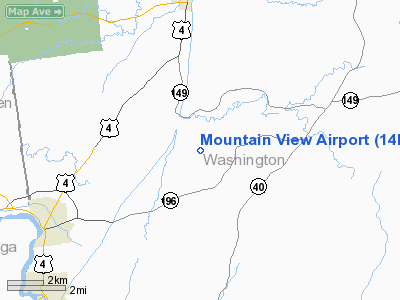
Location & QuickFacts
| FAA Information Effective: | 2008-09-25 |
| Airport Identifier: | 14NK |
| Airport Status: | Operational |
| Longitude/Latitude: | 073-28-44.4000W/43-20-24.0000N
-73.479000/43.340000 (Estimated) |
| Elevation: | 243 ft / 74.07 m () |
| Land: | 0 acres |
| From nearest city: | 5 nautical miles NE of Kingsbury, NY |
| Location: | Washington County, NY |
| Magnetic Variation: | () |
Owner & Manager
| Ownership: | Privately owned |
| Owner: | William W. Schmidt |
| Address: |
Effort, PA 18330 |
| Manager: | William W. Schmidt |
| Address: | Rr #1 Box
Effort, PA 18330 |
Airport Operations and Facilities
| Airport Use: | Private |
| Wind indicator: | Yes |
| Segmented Circle: | No |
| Control Tower: | No |
| Region: | AEA - Eastern |
| Boundary ARTCC: | ZBW - Boston |
| Tie-in FSS: | BTV - Burlington |
| FSS Toll Free: | 1-800-WX-BRIEF |
Airport Communications
Runway Information
Runway 02/20
| Dimension: | 1800 x 50 ft / 548.6 x 15.2 m |
| Surface: | TURF, |
| |
Runway 02 |
Runway 20 |
| Traffic Pattern: | Left | Left |
| Obstruction: | | 25 ft pline, 100.0 ft from runway |
|
Radio Navigation Aids
| ID |
Type |
Name |
Ch |
Freq |
Var |
Dist |
| R | FAN MARKER | Chitt | | | 14W | 28.3 nm |
| DYO | NDB | Smuto | | 221.00 | 15W | 31.7 nm |
| HEU | NDB | Hunter | | 356.00 | 14W | 35.4 nm |
| VWD | NDB | Mount Snow | | 224.00 | 15W | 36.6 nm |
| SXD | NDB | Springfield | | 265.00 | 15W | 39.3 nm |
| JJH | NDB | Johnstown | | 523.00 | 14W | 42.7 nm |
| IVV | NDB | White River | | 379.00 | 16W | 46.2 nm |
| CNH | NDB | Claremont | | 233.00 | 16W | 48.5 nm |
| CAM | VOR/DME | Cambridge | 097X | 115.00 | 14W | 21.6 nm |
| RUT | VOR/DME | Rutland | 47X | 111.00 | 15W | 25.6 nm |
| GFL | VORTAC | Glens Falls | 039X | 110.20 | 14W | 5.8 nm |
| ALB | VORTAC | Albany | 100X | 115.30 | 13W | 38.4 nm |
| ALB | VOT | Albany County | | 108.20 | | 39.0 nm |
Images and information placed above are from
http://www.airport-data.com/airport/14NK/
We thank them for the data!
|
|


