 |
|
Coordinates: 41°37′21″N 074°42′05″W / 41.6225°N 74.70139°W / 41.6225; -74.70139
| Monticello Airport |
| IATA: none – ICAO: none – FAA LID: N37 |
| Summary |
| Airport type |
Public |
| Owner |
The Jefferson Development Partners |
| Serves |
Monticello, New York |
| Elevation AMSL |
1,545 ft / 471 m |
| Runways |
| Direction |
Length |
Surface |
| ft |
m |
| 1/19 |
2,595 |
791 |
Asphalt |
| 15/33 |
2,072 |
632 |
Asphalt |
| Statistics (2005) |
| Aircraft operations |
15,000 |
| Based aircraft |
34 |
| Source: Federal Aviation Administration |
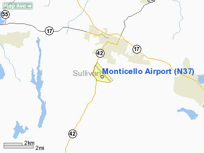
Monticello Airport (FAA LID: N37) was a public-use airport located two miles (3 km) south of the central business district of Monticello, a village in Sullivan County, New York, United States. It was privately owned by The Jefferson Development Partners.
Facilities and aircraft
Monticello Airport covered an area of 700 acres (283 ha) which contained two asphalt paved runways: 1/19 measuring 2,595 x 40 ft (791 x 12 m) and 15/33 measuring 2,072 x 24 ft (632 x 7 m). For the 12-month period ending August 30, 2005, the airport had 15,000 general aviationaircraft operations, an average of 41 per day.
As of late 2006, the airport was decommissioned, and the Monticello Motor Club was built on the property.
The above content comes from Wikipedia and is published under free licenses – click here to read more.
Location & QuickFacts
| FAA Information Effective: | 2008-09-25 |
| Airport Identifier: | N37 |
| Airport Status: | Closed Permanently |
| Longitude/Latitude: | 074-42-04.8000W/41-37-20.9000N
-74.701333/41.622472 (Estimated) |
| Elevation: | 1545 ft / 470.92 m (Surveyed) |
| Land: | 700 acres |
| From nearest city: | 2 nautical miles S of Monticello, NY |
| Location: | Sullivan County, NY |
| Magnetic Variation: | 13W (2000) |
Owner & Manager
| Ownership: | Privately owned |
| Owner: | The Jefferson Development Partners |
| Address: | Po Box 60
Monticello, NY 12701 |
| Phone number: | 845-798-0969 |
| Manager: | Henry Zabatta |
| Address: | 102 Lounsbury Place
Kingston, NY 12401 |
| Phone number: | 845-334-8534 |
Airport Operations and Facilities
| Airport Use: | Open to public |
| Wind indicator: | Yes |
| Segmented Circle: | No |
| Control Tower: | No |
| Landing fee charge: | No |
| Sectional chart: | New York |
| Region: | AEA - Eastern |
| Boundary ARTCC: | ZNY - New York |
| Tie-in FSS: | ISP - New York |
| FSS on Airport: | No |
| FSS Toll Free: | 1-800-WX-BRIEF |
| NOTAMs Facility: | ISP (NOTAM-d service avaliable) |
Airport Communications
| CTAF: | 122.800 |
| Unicom: | 122.800 |
Airport Services
| Fuel available: | 100LL |
| Airframe Repair: | MAJOR |
| Power Plant Repair: | MAJOR |
| Bottled Oxygen: | NONE |
| Bulk Oxygen: | NONE |
Runway Information
Runway 01/19
| Dimension: | 2595 x 40 ft / 791.0 x 12.2 m
RY 01/19 NORTH 214 FT IS 31 FT WIDE. |
| Surface: | ASPH, Fair Condition
RY 15/33 HAS BROKEN AREAS, EMERGENCY USE ONLY. |
| |
Runway 01 |
Runway 19 |
| Longitude: | 074-42-08.4520W | 074-42-08.3004W |
| Latitude: | 41-37-04.4872N | 41-37-30.1212N |
| Elevation: | 1541.00 ft | 1528.00 ft |
| Alignment: | 127 | 127 |
| Traffic Pattern: | Left | Left |
| Markings: | Basic, Poor Condition
RWY 1 MARKINGS FADED | Nonstandard, Poor Condition
RWY 19 MARKINGS FADED |
| Obstruction: | 14 ft bldg, 307.0 ft from runway, 150 ft left of centerline, 7:1 slope to clear
RY 01 APCH SLOPE 12:1 TO DSPLCD THLD BASED ON 15 FT VEHICLE ON ROAD 30 FT FM RY END.
+15' ROAD 23' FM THR. | 19 ft trees, 301.0 ft from runway, 81 ft left of centerline, 5:1 slope to clear
RY 19 APCH SLOPE 27:1 TO DSPLCD THLD.
+20' TREES 120'L. |
|
Runway 15/33
| Dimension: | 2072 x 24 ft / 631.5 x 7.3 m
RY 01/19 NORTH 214 FT IS 31 FT WIDE. |
| Surface: | ASPH, Poor Condition
RY 15/33 HAS BROKEN AREAS, EMERGENCY USE ONLY. |
| |
Runway 15 |
Runway 33 |
| Longitude: | 074-42-09.5280W | 074-41-51.0346W |
| Latitude: | 41-37-32.8371N | 41-37-17.7832N |
| Elevation: | 1523.00 ft | 1532.00 ft |
| Alignment: | 127 | 127 |
| Traffic Pattern: | Left | Left |
| Markings: | Basic, Poor Condition
RWY 15 MARKINGS FADED | Basic, Poor Condition
RWY 33 MARKINGS FADED |
| Obstruction: | 30 ft trees, 245.0 ft from runway, 95 ft left of centerline, 1:1 slope to clear
RY 15 +9 FT TREE 147 FT FROM THRESHOLD ON CENTERLINE. | 26 ft trees, 231.0 ft from runway, 108 ft left of centerline, 1:1 slope to clear
+15' BRUSH & TREES 100-200' FM THR. |
|
Radio Navigation Aids
| ID |
Type |
Name |
Ch |
Freq |
Var |
Dist |
| SKU | FAN MARKER | Stanwyck | | | 12W | 30.1 nm |
| MS | NDB | Monga | | 359.00 | 12W | 11.2 nm |
| SW | NDB | Neely | | 335.00 | 14W | 22.8 nm |
| SKU | NDB | Stanwyck | | 261.00 | 12W | 30.1 nm |
| PO | NDB | Meier | | 403.00 | 12W | 33.2 nm |
| PNJ | NDB | Paterson | | 347.00 | 12W | 47.6 nm |
| HUO | VOR/DME | Huguenot | 108X | 116.10 | 11W | 13.7 nm |
| DNY | VOR/DME | De Lancey | 058X | 112.10 | 11W | 35.3 nm |
| HNK | VOR/DME | Hancock | 115X | 116.80 | 11W | 38.2 nm |
| STW | VOR/DME | Stillwater | 033X | 109.60 | 11W | 38.4 nm |
| IGN | VOR/DME | Kingston | 123X | 117.60 | 12W | 39.6 nm |
| BWZ | VOR/DME | Broadway | 089X | 114.20 | 11W | 49.8 nm |
| SAX | VORTAC | Sparta | 104X | 115.70 | 11W | 34.2 nm |
| LHY | VORTAC | Lake Henry | 045X | 110.80 | 10W | 36.2 nm |
| LVZ | VORTAC | Wilkes-barre | 053X | 111.60 | 10W | 49.2 nm |
Remarks
- HIGH TENSION TOWERS & LINE 3200' FM RY 19, 200'L, +123', 24:1.
- HIGH TENSION TOWERS & LINE 6000' FM RY 15, 1200'L, +260', 22:1.
- DEER ON & INVOF ARPT.
- RY 15/33 HIGH POTENTIAL FOR FOREIGN OBJECT DAMAGE.
- (ARPT STATUS) ARPT CLSD PERMLY.
- VFR USE ONLY.
Images and information placed above are from
http://www.airport-data.com/airport/N37/
We thank them for the data!
| General Info
|
| Country |
United States
|
| State |
NEW YORK
|
| FAA ID |
N37
|
| Latitude |
41-37-20.970N
|
| Longitude |
074-42-05.080W
|
| Elevation |
1545 feet
|
| Near City |
MONTICELLO
|
We don't guarantee the information is fresh and accurate. The data may
be wrong or outdated.
For more up-to-date information please refer to other sources.
|
|


