|
|
| Montauk Airport |
 |
| IATA: MTP – ICAO: KMTP |
| Summary |
| Airport type |
Public |
| Operator |
Montauk Airport Inc. |
| Location |
Montauk, New York |
| Elevation AMSL |
6 ft / 1.8 m |
| Coordinates |
41°04′36″N 71°55′13.7″W / 41.07667°N 71.920472°W / 41.07667; -71.920472Coordinates: 41°04′36″N 71°55′13.7″W / 41.07667°N 71.920472°W / 41.07667; -71.920472 |
| Runways |
| Direction |
Length |
Surface |
| ft |
m |
| 6/24 |
3,246 |
989 |
Asphalt |
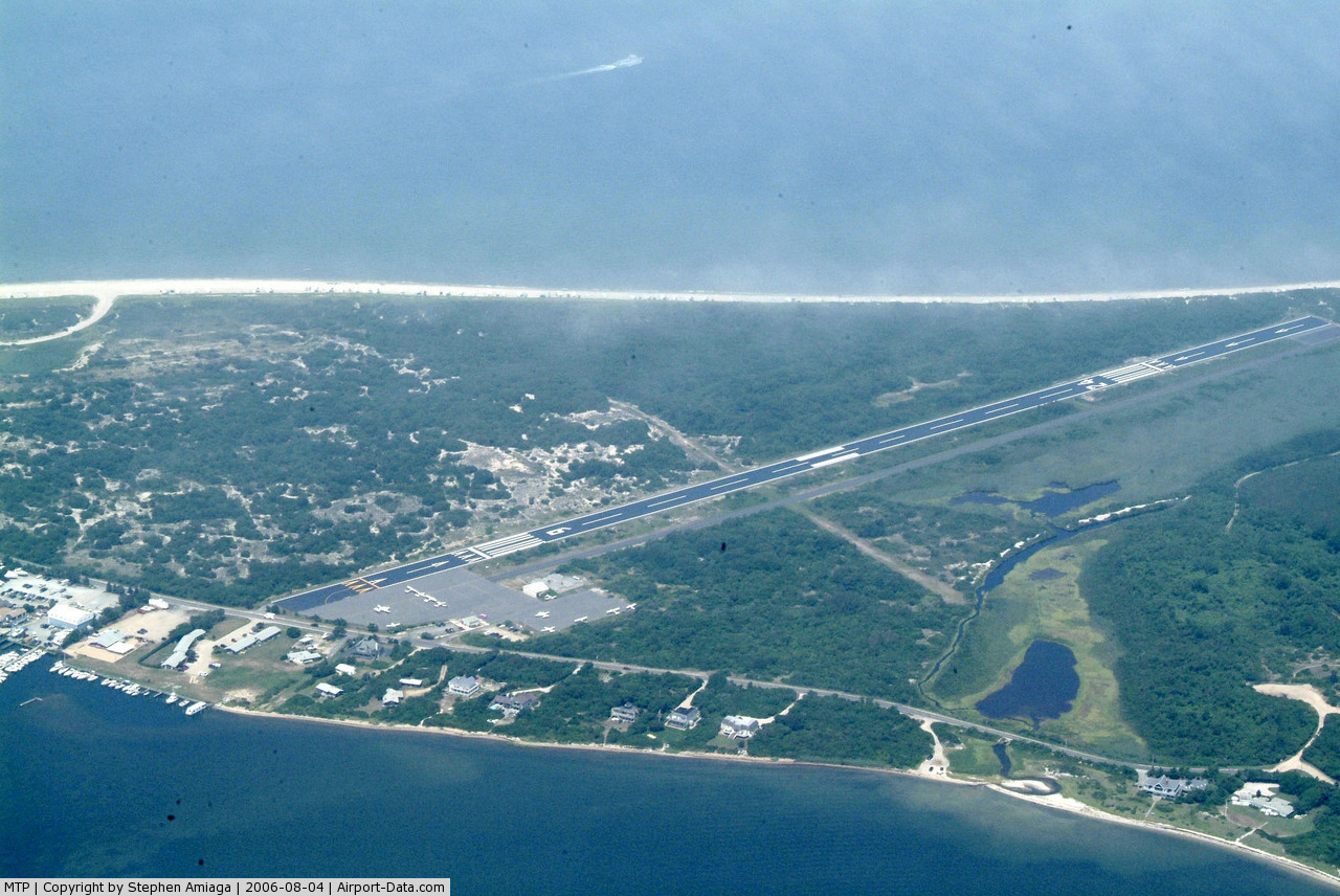
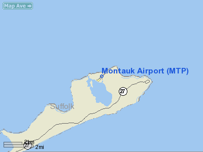
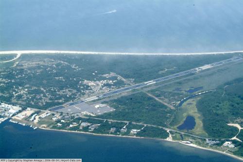
Montauk Airport (IATA: MTP, ICAO: KMTP) is a public airport located on East Lake Drive between Lake Montauk and Block Island Sound, approximately 3 miles (4.8 km) northeast of Montauk, in Suffolk County, New York, USA. Montauk Airport is the easternmost airport in New York State. History
Montauk Airport was constructed in 1957 to improve access to the East End community, which was being developed as a summer resort. Perry Duryea Jr., a former pilot of the Naval Air Transport Service, was one of the early partners of the corporation that developed the airport, and often piloted his own plane between Montauk and Albany while serving as a member of the New York State Assembly. The following year, regular flights were proposed between Montauk and LaGuardia Airport in New York City during the summer season for use by vacationers and sport fishermen.
In 2007, Montauk Airport received two grants from the Federal Aviation Administration to install an Automated Weather Observing System to provide pilots with current weather conditions at the airport and a Precision Approach Path Indicator to visually alert pilots if they are on the glidepath while preparing to land. An additional grant was received from the FAA in 2008 to install taxiway edge lights.
Facilities
Montauk Airport covers 40 acres (16 ha) and has one runway:
- Runway 6/24: 3,246 x 75 ft (989 x 23 m), Surface: Asphalt
Incidents
- On March 7, 2009, a Cirrus SR22 went off the runway and burst into flames while practicing a takeoff from the Montauk Airport. The student pilot and instructor escaped from the aircraft without injuries.
- On July 31, 2007, a Piper PA-28-181 crashed into trees at the Montauk Airport after aborting a landing and attempting a go-around. The pilot was uninjured and rescued by an airport employee and two people from a nearby beach.
- On July 7, 2003, a Piper PA-34-200T crashed into the waters of Big Reed Pond in Montauk County Park after taking off from the Montauk Airport, killing the pilot and two passengers. The men had gone out earlier in the evening on a fishing trip for striped bass and were flying back to Republic Airport during the middle of the night. The plane was discovered the next morning by a family canoeing in the pond.
The above content comes from Wikipedia and is published under free licenses – click here to read more.
 |
(Click on the photo to enlarge) |
Location & QuickFacts
| FAA Information Effective: | 2008-09-25 |
| Airport Identifier: | MTP |
| Airport Status: | Operational |
| Longitude/Latitude: | 071-55-14.7700W/41-04-35.2438N
-71.920769/41.076457 (Estimated) |
| Elevation: | 6 ft / 1.83 m (Surveyed) |
| Land: | 40 acres |
| From nearest city: | 3 nautical miles NE of Montauk, NY |
| Location: | Suffolk County, NY |
| Magnetic Variation: | 15W (2000) |
Owner & Manager
| Ownership: | Privately owned |
| Owner: | Montauk Airport Inc |
| Address: | P.o. Box 1477
Montauk, L.i., NY 11954 |
| Phone number: | 631-668-2484 |
| Manager: | Helen Gill |
| Address: | Box 1477
Montauk, L.i., NY 11954 |
| Phone number: | 631-668-3738 |
Airport Operations and Facilities
| Airport Use: | Open to public |
| Wind indicator: | Yes |
| Segmented Circle: | No |
| Control Tower: | No |
| Lighting Schedule: | RDO-CTL
ACTVT MIRL RY 06/24 - 121.7. |
| Landing fee charge: | Yes |
| Sectional chart: | New York |
| Region: | AEA - Eastern |
| Boundary ARTCC: | ZBW - Boston |
| Tie-in FSS: | ISP - New York |
| FSS on Airport: | No |
| FSS Toll Free: | 1-800-WX-BRIEF |
| NOTAMs Facility: | MTP (NOTAM-d service avaliable) |
| Federal Agreements: | N |
Airport Communications
| CTAF: | 122.700 |
| Unicom: | 122.700 |
Airport Services
| Airframe Repair: | NONE |
| Power Plant Repair: | NONE |
| Bottled Oxygen: | NONE |
| Bulk Oxygen: | NONE |
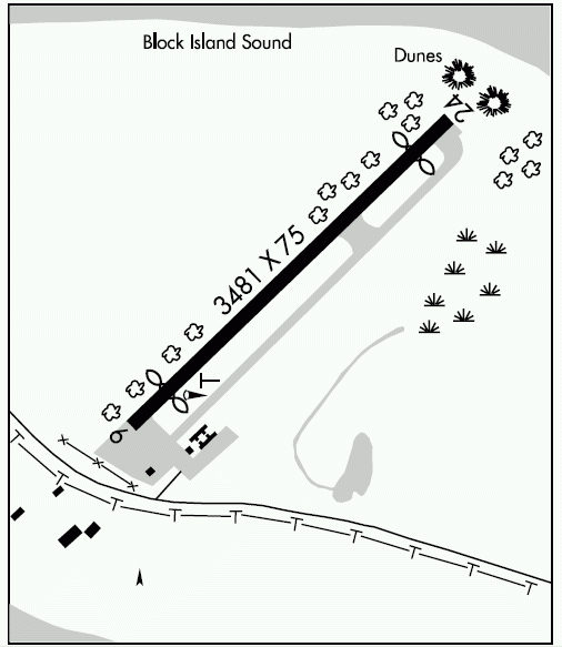
Runway Information
Runway 06/24
| Dimension: | 3481 x 75 ft / 1061.0 x 22.9 m |
| Surface: | ASPH, Good Condition |
| Edge Lights: | Medium |
| |
Runway 06 |
Runway 24 |
| Longitude: | 071-55-31.3960W | 071-54-58.1430W |
| Latitude: | 41-04-23.5250N | 41-04-46.9730N |
| Elevation: | 7.00 ft | 4.00 ft |
| Alignment: | 47 | 127 |
| Traffic Pattern: | Left | Right |
| Markings: | Non-precision instrument, Good Condition | Non-precision instrument, Good Condition |
| Displaced threshold: | 537.00 ft | 457.00 ft |
| Obstruction: | 23 ft trees, 201.0 ft from runway, 62 ft left of centerline
RY APCH RATIO 0:1 TO DSPLCD THLD.
RY 06 +13'-18' TREES & BRUSH, 0'-200' FRM THLD, 62'-90' LEFT. | 37 ft dune, 225.0 ft from runway, 45 ft right of centerline
RY 24 APCH RATIO 0:1 TO DSPLCD THLD.
RWY 24, +17'-24' FT TREES & BRUSH, 36' - 88' FRM THLD, 130' RIGHT; +8' BRUSH, 34' FRM THLD, LEFT AND RIGHT |
|
Radio Navigation Aids
| ID |
Type |
Name |
Ch |
Freq |
Var |
Dist |
| HF | NDB | Lomis | | 244.00 | 15W | 46.3 nm |
| MMK | NDB | Meriden | | 238.00 | 14W | 48.6 nm |
| FOK | TACAN | Suffolk Co | 047X | | 13W | 35.3 nm |
| GON | VOR/DME | Groton | 45Y | 110.85 | 14W | 16.4 nm |
| SEY | VOR/DME | Sandy Point | 125X | 117.80 | 15W | 16.5 nm |
| ORW | VOR/DME | Norwich | 037X | 110.00 | 14W | 29.1 nm |
| MAD | VOR/DME | Madison | 041X | 110.40 | 13W | 37.7 nm |
| CCC | VOR/DME | Calverton | 119X | 117.20 | 13W | 40.8 nm |
| HFD | VOR/DME | Hartford | 096X | 114.90 | 13W | 44.2 nm |
| HVN | VOR/DME | New Haven | 035X | 109.80 | 13W | 45.0 nm |
| HTO | VORTAC | Hampton | 083X | 113.60 | 13W | 20.3 nm |
| PVD | VORTAC | Providence | 103X | 115.60 | 14W | 44.8 nm |
| GON | VOT | Groton | | 110.25 | | 16.1 nm |
| PVD | VOT | Providence | | 108.20 | | 44.8 nm |
Remarks
- ARPT CLSD TO HEL OPNS SS-SR; PPR.
- DEER OCNLLY ON OR IN VCNTY OF ARPT.
- ARPT CLSD TO JET ACFT EXCEPT PPR CALL AMGR (631) 668-3738.
- HELICOPTERS CALL FOR PRIOR PERMISSION TO LND ON RAMP AREA.
- RY 06, +18' BRUSH. ALONG RWY EDGE, 90'L; +26' POLE, 400' FRM THLD, 79'L.
- RY 06, +11' TREE, 298' FRM THLD, 28'L; +11' TREE, 267' FRM THLD, 39'R.
- RWY 24, +21' BRUSH, ALONG RWY EDGE, 87' RIGHT
- EXISTED PRIOR TO 1959.
Images and information placed above are from
http://www.airport-data.com/airport/MTP/
We thank them for the data!
| General Info
|
| Country |
United States
|
| State |
NEW YORK
|
| FAA ID |
MTP
|
| Latitude |
41-04-36.996N
|
| Longitude |
071-55-13.439W
|
| Elevation |
20 feet
|
| Near City |
MONTAUK
|
We don't guarantee the information is fresh and accurate. The data may
be wrong or outdated.
For more up-to-date information please refer to other sources.
|
|