 |
|
| Michael Airfield |
 |
| Michael Airfield, 27 March 1995 |
| IATA: none – ICAO: none – FAA LID: 1G6 |
| Summary |
| Airport type |
public |
| Owner |
David Pizio |
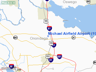
| Location |
Cicero, New York |
| Built |
1944 |
| Elevation AMSL |
400 ft / 122 m |
| Coordinates |
43°10′54″N 76°07′40″W / 43.18167°N 76.12778°W / 43.18167; -76.12778 |
| Runways |
| Direction |
Length |
Surface |
| ft |
m |
| 10/ 28 |
2,500 |
760 |
asphalt |
| Statistics (2006) |
| Operations |
1,502 |
| Based aircraft |
1 |
| Source: Federal Aviation Administration |
Michael Airfield (FAA LID: 1G6) is a public airport located on 34 acres just northwest of the central business district of Cicero, New York, United States. The airport is privately owned but open to public flight operations. Facilities and background
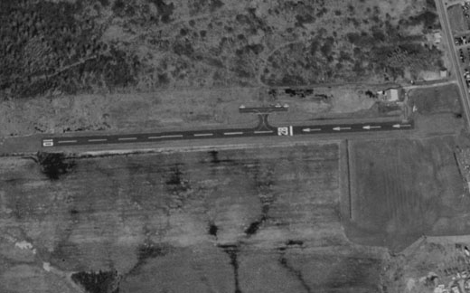
CLOSED BY FAA NYADO AUGUST 2009. PUBLIC USE OPERATIONS TO BE TAKEN OVER BY SYRACUSE SUBURBAN 6NK AFTER RECONSTRUCTION. Michael Airfield's sole runway, 10/28, was 2,500 feet (760 m) long with a grooved asphalt surface. According to the Federal Aviation Administration's airport master record for Michael Airfield, issued following a September 27, 2006 inspection, runway markings for 10/28 were very faded and the field was unattended. The airport, which sits beneath Syracuse Hancock International Airport's Class C airspace, was established in December 1944. In the 1990s, the little used airport was unable to cover its taxes and put up for sale for US$500,000.
The airport, now owned by David Pizio, was listed in the third addition of John Purner's book The $100 Hamburger: A Guide to Pilots' Favorite Fly-in Restaurants. A $100 Hamburger is aviation slang referring to a meal eaten at an airport or nearby restaurant following a general aviation flight made by a pilot who, looking for an excuse to fly, decides to eat at a non-local airport.
The above content comes from Wikipedia and is published under free licenses – click here to read more.
Location & QuickFacts
| FAA Information Effective: | 2008-09-25 |
| Airport Identifier: | 1G6 |
| Airport Status: | Operational |
| Longitude/Latitude: | 076-07-40.0000W/43-10-54.0000N
-76.127778/43.181667 (Estimated) |
| Elevation: | 400 ft / 121.92 m (Estimated) |
| Land: | 34 acres |
| From nearest city: | 0 nautical miles NW of Cicero, NY |
| Location: | Onondaga County, NY |
| Magnetic Variation: | 12W (1985) |
Owner & Manager
| Ownership: | Privately owned |
| Owner: | David Pizio |
| Address: | 2063 Jamesville Terrace
Jamesville, NY 13078 |
| Phone number: | 315-436-4040 |
| Manager: | David Pizio |
| Address: | Brewerton Rd. Rte 11
Cicero, NY 13039 |
| Phone number: | 315-436-4040 |
Airport Operations and Facilities
| Airport Use: | Open to public |
| Wind indicator: | Yes |
| Segmented Circle: | No |
| Control Tower: | No |
| Sectional chart: | New York |
| Region: | AEA - Eastern |
| Traffic Pattern Alt: | 800 ft |
| Boundary ARTCC: | ZBW - Boston |
| Tie-in FSS: | BUF - Buffalo |
| FSS on Airport: | No |
| FSS Toll Free: | 1-800-WX-BRIEF |
| NOTAMs Facility: | BUF (NOTAM-d service avaliable) |
| Federal Agreements: | NGY |
Airport Communications
| CTAF: | 122.800 |
| Unicom: | 122.800 |
Airport Services
| Bottled Oxygen: | NONE |
| Bulk Oxygen: | NONE |
Runway Information
Runway 10/28
| Dimension: | 2500 x 60 ft / 762.0 x 18.3 m |
| Surface: | ASPH, Good Condition |
| Weight Limit: | Single wheel: 13000 lbs. |
| |
Runway 10 |
Runway 28 |
| Traffic Pattern: | Left | Left |
| Markings: | Basic, Poor Condition
MARKINGS VERY FADED | Basic, Poor Condition
MARKINGS VERY FADED |
| Displaced threshold: | 0.00 ft | 817.00 ft |
| Runway End Identifier: | No | No |
| Centerline Lights: | No | No |
| Touchdown Lights: | No | No |
| Obstruction: | 11 ft trees, 205.0 ft from runway, 60 ft left of centerline | 87 ft trees, 599.0 ft from runway, 99 ft right of centerline, 4:1 slope to clear
RWY 28 APCH RATIO 13:1 TO DSPLCD THLD. |
|
Radio Navigation Aids
| ID |
Type |
Name |
Ch |
Freq |
Var |
Dist |
| BK | NDB | Plein | | 329.00 | 12W | 28.4 nm |
| CJY | NDB | Clay | | 275.00 | 12W | 38.7 nm |
| GSS | TACAN | Griffiss | 057X | | 12W | 31.5 nm |
| ITH | VOR/DME | Ithaca | 055X | 111.80 | 10W | 43.8 nm |
| SYR | VORTAC | Syracuse | 117X | 117.00 | 11W | 3.6 nm |
| GGT | VORTAC | Georgetown | 125X | 117.80 | 11W | 27.1 nm |
| UCA | VORTAC | Utica | 049X | 111.20 | 12W | 43.3 nm |
| ART | VORTAC | Watertown | 035X | 109.80 | 12W | 46.4 nm |
Remarks
- RWY PLOWED DURING WINTER.
- FEE FOR COML & BUS OPNS.
- BIRDS & DEER ON & INVOF ARPT.
- RWY 28: +74' TREES, 43' LT., 690' FRM RWY; +84' TREES, 166' LT., 742' FRM RWY
- RWY 10: +48' TREES, 88' RT., 260' FRM RWY; +66' TREES, +18' LT., 1210 FRM RWY
- GOLF PRACTICE RANGE 60' SOUTH OF RWY EDGE
- OBSTR. BALLS ON HIGH TENS. LINES (NORTH EAST OF ARPT.) ARE FADED LIGHT RED TO WHITE IN COLOR
- EXISTED PRIOR TO 1959.
Images and information placed above are from
http://www.airport-data.com/airport/1G6/
We thank them for the data!
| General Info
|
| Country |
United States
|
| State |
NEW YORK
|
| FAA ID |
1G6
|
| Latitude |
43-10-54.000N
|
| Longitude |
076-07-40.000W
|
| Elevation |
400 feet
|
| Near City |
CICERO
|
We don't guarantee the information is fresh and accurate. The data may
be wrong or outdated.
For more up-to-date information please refer to other sources.
|
|


