 |
|
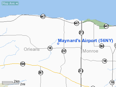
Location & QuickFacts
| FAA Information Effective: | 2008-09-25 |
| Airport Identifier: | 56NY |
| Airport Status: | Operational |
| Longitude/Latitude: | 078-02-59.0610W/43-19-31.2110N
-78.049739/43.325336 (Estimated) |
| Elevation: | 342 ft / 104.24 m (Estimated) |
| Land: | 0 acres |
| From nearest city: | 1 nautical miles NE of Kendall, NY |
| Location: | Orleans County, NY |
| Magnetic Variation: | 11W (1990) |
Owner & Manager
| Ownership: | Privately owned |
| Owner: | Mark L. Maynard |
| Address: | 16562 Kenmore Rd
Kendall, NY 14476 |
| Phone number: | 716-659-8642 |
| Manager: | Mark L. Maynard |
| Address: | 16562 Kenmore Rd
Kendall, NY 14476 |
| Phone number: | 716-659-8642 |
Airport Operations and Facilities
| Airport Use: | Private |
| Wind indicator: | Yes |
| Segmented Circle: | No |
| Control Tower: | No |
| Sectional chart: | Detroit |
| Region: | AEA - Eastern |
| Boundary ARTCC: | ZOB - Cleveland |
| Tie-in FSS: | BUF - Buffalo |
| FSS on Airport: | No |
| FSS Toll Free: | 1-800-WX-BRIEF |
Runway Information
Runway 09/27
| Dimension: | 3003 x 36 ft / 915.3 x 11.0 m |
| Surface: | TURF, |
| |
Runway 09 |
Runway 27 |
| Traffic Pattern: | Left | Left |
| Obstruction: | 40 ft plines | 40 ft plines |
|
Radio Navigation Aids
| ID |
Type |
Name |
Ch |
Freq |
Var |
Dist |
| AVN | NDB | Avon | | 344.00 | 09W | 22.6 nm |
| R | NDB | Romeo | | 317.00 | 12W | 47.4 nm |
| IAG | TACAN | Niagara Falls | 047X | | 10W | 41.9 nm |
| GEE | VOR/DME | Geneseo | 019X | 108.20 | 09W | 32.6 nm |
| BUF | VOR/DME | Buffalo | 111X | 116.40 | 08W | 35.4 nm |
| ROC | VORTAC | Rochester | 037X | 110.00 | 09W | 20.6 nm |
| BUF | VOT | Buffalo | | 109.00 | | 37.9 nm |
Remarks
- PRVDD THRS ESTABLISHED TO PROVIDED CLEAR 20:1 APCH SURFACE; STRUCTURES & TREES ON BOTH SIDES OF THE RY DO NOT PENETRATE THE PRIMARY/TRANSITIONAL SURFACE.
Images and information placed above are from
http://www.airport-data.com/airport/56NY/
We thank them for the data!
| General Info
|
| Country |
United States
|
| State |
NEW YORK
|
| FAA ID |
56NY
|
| Latitude |
43-19-31.211N
|
| Longitude |
078-02-59.061W
|
| Elevation |
342 feet
|
| Near City |
KENDALL
|
We don't guarantee the information is fresh and accurate. The data may
be wrong or outdated.
For more up-to-date information please refer to other sources.
|
|


