 |
|
Massena Intl-richards Field Airport |
Massena International Airport
Richards Field |
 |
| IATA: MSS – ICAO: KMSS |
| Summary |
| Airport type |
Public |
| Operator |
Town of Massena |
| Location |
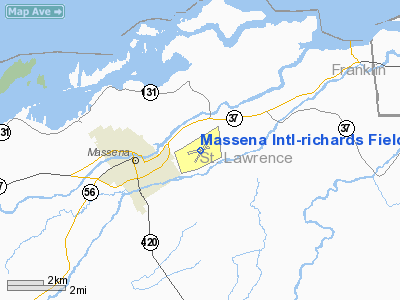
Massena, New York |
| Elevation AMSL |
215 ft / 65.5 m |
| Coordinates |
44°56′09″N 74°50′44″W / 44.93583°N 74.84556°W / 44.93583; -74.84556Coordinates: 44°56′09″N 74°50′44″W / 44.93583°N 74.84556°W / 44.93583; -74.84556 |
| Runways |
| Direction |
Length |
Surface |
| ft |
m |
| 5/23 |
5,600 |
4,000 |
Asphalt |
| 9/27 |
4,000 |
1,219 |
Asphalt |
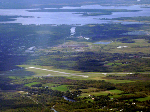
Massena International Airport (IATA: MSS, ICAO: KMSS), also known as Richards Field, is a public airport located two miles (3 km) east of the central business district (CBD) of Massena, a village in St. Lawrence County, New York, USA. The airport, owned by the Town of Massena, covers 476 acres (193 ha) and has two runways. It is mostly used for general aviation.
The airport is served commercially by Cape Air, with direct flights to Albany International Airport in Albany, New York on 9-seat Cessna 402 aircraft. This service is subsidized by the Essential Air Service program. Prior to Cape Air's service, the airport was served by Big Sky Airlines, with flights to Boston Logan International Airport (with stops in Ogdensburg and Watertown in 2007). Prior to that, service was provided by Air Midwest, with flights to Pittsburgh International Airport.
As per Federal Aviation Administration records, the airport had 3,083 passenger boardings (enplanements) in calendar year 2004 and 3,218 enplanements in 2005. According to the FAA's National Plan of Integrated Airport Systems for 2007–2011, Massena is classified as commercial service - non-primary because it has between 2,500 and 10,000 passenger boardings per year. Airlines and destinations
| Airlines |
Destinations |
| Cape Air |
Albany |
Facilities
Air freight, charter, limo, courier, and overnight express, as well as full service for jet aircraft refueling are among the services offered by the airport. VOR, ILS, and RNAV navigational approaches are featured for the runways.
The Massena International Airport is also a U.S. Customs Port of Entry for planes entering the United States from Canada or other foreign countries. A one hour advance ETA notice is required for unscheduled flights.
The above content comes from Wikipedia and is published under free licenses – click here to read more.
Location & QuickFacts
| FAA Information Effective: | 2008-09-25 |
| Airport Identifier: | MSS |
| Airport Status: | Operational |
| Longitude/Latitude: | 074-50-44.0000W/44-56-09.0000N
-74.845556/44.935833 (Estimated) |
| Elevation: | 215 ft / 65.53 m (Surveyed) |
| Land: | 476 acres |
| From nearest city: | 2 nautical miles E of Massena, NY |
| Location: | St Lawrence County, NY |
| Magnetic Variation: | 14W (1980) |
Owner & Manager
| Ownership: | Publicly owned |
| Owner: | Town Of Massena |
| Address: | Main St - Town Hall
Massena, NY 13662 |
| Phone number: | 315-769-3588 |
| Manager: | Donald La Baff |
| Address: | 90 Aviation Road
Massena, NY 13662 |
| Phone number: | 315-769-7605 |
Airport Operations and Facilities
| Airport Use: | Open to public |
| Wind indicator: | Yes |
| Segmented Circle: | No |
| Control Tower: | No |
| Lighting Schedule: | DUSK-DAWN
ACTVT HIRL RYS 05/23, MIRL RY 09/27, PAPI RY 27, REIL RYS 05 & 27 7TWY LGTS - CTAF. |
| Beacon Color: | Clear-Green (lighted land airport) |
| Landing fee charge: | No |
| Sectional chart: | Montreal |
| Region: | AEA - Eastern |
| Boundary ARTCC: | ZBW - Boston |
| Tie-in FSS: | BTV - Burlington |
| FSS on Airport: | No |
| FSS Toll Free: | 1-800-WX-BRIEF |
| NOTAMs Facility: | MSS (NOTAM-d service avaliable) |
| Certification type/date: | II A S 01/197
PPR 24 HRS FOR ACR OPNS WITH MORE THAN 30 PSGR SEATS; CALL AMGR (315) 769-7605. |
| Federal Agreements: | NGY3 |
Airport Communications
| CTAF: | 123.000 |
| Unicom: | 123.000 |
Airport Services
| Fuel available: | 100LLA |
| Airframe Repair: | MINOR |
| Power Plant Repair: | NONE |
| Bottled Oxygen: | NONE |
| Bulk Oxygen: | NONE |
Runway Information
Runway 05/23
| Dimension: | 5600 x 100 ft / 1706.9 x 30.5 m |
| Surface: | ASPH, Good Condition |
| Surface Treatment: | Saw-cut or plastic Grooved
RYS 05 & 09/27 FIRST 50 FT NOT GRVD. |
| Pavement Class: | 18 /F/C/X/T |
| Weight Limit: | Single wheel: 30000 lbs.
Dual wheel: 50000 lbs.
Dual tandem wheel: 76000 lbs. |
| Edge Lights: | High |
| |
Runway 05 |
Runway 23 |
| Longitude: | 074-50-57.8333W | 074-50-17.4750W |
| Latitude: | 44-55-48.1078N | 44-56-35.3970N |
| Elevation: | 203.00 ft | 222.00 ft |
| Alignment: | 31 | 127 |
| ILS Type: | ILS
| |
| Traffic Pattern: | Left | Left |
| Markings: | Precision instrument, Good Condition | Non-precision instrument, Good Condition |
| Crossing Height: | 59.00 ft | 0.00 ft |
| VASI: | 4-light PAPI on left side | |
| Visual Glide Angle: | 3.00° | 0.00° |
| Runway End Identifier: | Yes | |
| Obstruction: | 45 ft tree, 1000.0 ft from runway, 540 ft right of centerline, 17:1 slope to clear | 110 ft trees, 650.0 ft from runway, 600 ft right of centerline, 4:1 slope to clear |
|
Runway 09/27
| Dimension: | 4000 x 100 ft / 1219.2 x 30.5 m |
| Surface: | ASPH, Good Condition |
| Surface Treatment: | Saw-cut or plastic Grooved
RYS 05 & 09/27 FIRST 50 FT NOT GRVD. |
| Weight Limit: | Single wheel: 30000 lbs.
Dual wheel: 50000 lbs.
Dual tandem wheel: 76000 lbs. |
| Edge Lights: | Medium |
| |
Runway 09 |
Runway 27 |
| Longitude: | 074-51-16.1195W | 074-50-22.1089W |
| Latitude: | 44-56-03.9794N | 44-56-13.3769N |
| Elevation: | 203.00 ft | 204.00 ft |
| Alignment: | 76 | 127 |
| Traffic Pattern: | Left | Left |
| Markings: | Non-precision instrument, Good Condition | Nonstandard, Good Condition
NSTD NPI - NO AIMING POINT MARKINGS. |
| Crossing Height: | 0.00 ft | 35.00 ft |
| VASI: | | 4-light PAPI on left side |
| Visual Glide Angle: | 0.00° | 3.00° |
| Runway End Identifier: | | Yes |
| Obstruction: | 53 ft trees, 990.0 ft from runway, 280 ft left of centerline, 14:1 slope to clear | 67 ft trees, 1130.0 ft from runway, 400 ft left of centerline, 13:1 slope to clear |
|
Radio Navigation Aids
| ID |
Type |
Name |
Ch |
Freq |
Var |
Dist |
| PTD | NDB | Potsdam | | 400.00 | 14W | 12.9 nm |
| YUP | NDB | Uplands | | 352.00 | 14W | 32.7 nm |
| YRR | NDB | Greely | | 377.00 | 14W | 36.8 nm |
| OW | NDB | Ottawa | | 236.00 | 14W | 39.6 nm |
| O | NDB | Oscar | | 344.00 | 14W | 43.5 nm |
| YSH | NDB | Smiths Falls | | 334.00 | 13W | 49.6 nm |
| UUP | TACAN | Uplands | 025X | | 14W | 41.9 nm |
| SLK | VOR/DME | Saranac Lake | 029X | 109.20 | 14W | 43.0 nm |
| MSS | VORTAC | Massena | 088X | 114.10 | 14W | 5.4 nm |
Remarks
- FREQUENT CONCENTRATION OF SEAGULLS AND CANADA GEESE ON AND INVOF ARPT PARTICULARLY DURG POOR WX PERIODS.
- 421 FT LGTD/MKD TWR 6000 FT S OF ARPT.
- BIRDS & DEER ON & INVOF ARPT.
- RY CONDS RPRTD DUR NML HRS OF OPN.
- OVERNIGHT ACFT PARKING AVBL AT TERMINAL APRON.
- AFTER ATTENDANCE HRS VEHICLE & PEDESTRIAN ACCESS TO FBO APRON & HANGAR ONLY AVBL WITH KEY CARD FOR AUTOMATIC GATE.
- FILED FOR RECORD PURPOSES ONLY.
Images and information placed above are from
http://www.airport-data.com/airport/MSS/
We thank them for the data!
| General Info
|
| Country |
United States
|
| State |
NEW YORK
|
| FAA ID |
MSS
|
| Latitude |
44-56-09.000N
|
| Longitude |
074-50-44.000W
|
| Elevation |
215 feet
|
| Near City |
MASSENA
|
We don't guarantee the information is fresh and accurate. The data may
be wrong or outdated.
For more up-to-date information please refer to other sources.
|
|


