 |
|
Coordinates: 42°16′20″N 074°23′39″W / 42.27222°N 74.39417°W / 42.27222; -74.39417
| Maben Airport |
| IATA: none – ICAO: none – FAA LID: N00 |
| Summary |
| Airport type |
Public |
| Owner |
Dr. Wayne Maben, MD |
| Location |
Lexington / Prattsville, New York |
| Elevation AMSL |
1,800 ft / 549 m |
| Runways |
| Direction |
Length |
Surface |
| ft |
m |
| 3/21 |
4,000 |
1,219 |
Turf/Gravel |
| Statistics (2002) |
| Aircraft operations |
3,650 |
| Based aircraft |
10 |
| Source: Federal Aviation Administration |
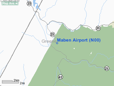
Maben Airport (FAA LID: N00) is a public-use airport located in Prattsville, in Greene County, New York, United States. It is privately owned by Dr. Wayne Maben, M.D. and was founded in 1948 by his father, Robert Maben. It is currently closed indefinitely.
Facilities and aircraft
Maben Airport covers an area of 5 acres (2 ha) which contains one turf & gravel runway (3/21) measuring 4,000 x 50 ft (1,219 x 15 m). For the 12-month period ending August 2, 2002, the airport had 3,650 aircraft operations: 96% general aviation and 4% military. During that period there were 10 aircraft based at this airport, 100% of which were single-engine.
The above content comes from Wikipedia and is published under free licenses – click here to read more.
Location & QuickFacts
| FAA Information Effective: | 2008-09-25 |
| Airport Identifier: | N00 |
| Airport Status: | Closed Indefinitely |
| Longitude/Latitude: | 074-23-38.5320W/42-16-20.3080N
-74.394037/42.272308 (Estimated) |
| Elevation: | 1800 ft / 548.64 m (Estimated) |
| Land: | 5 acres |
| From nearest city: | 2 nautical miles NW of Lexington/prattsville, NY |
| Location: | Greene County, NY |
| Magnetic Variation: | 13W (1985) |
Owner & Manager
| Ownership: | Privately owned |
| Owner: | Dr Wayne Maben, Md |
| Address: | 76 Fingar Road
Hudson, NY 12534 |
| Phone number: | 518-697-3000 |
| Address: |
|
Airport Operations and Facilities
| Airport Use: | Open to public |
| Wind indicator: | Yes |
| Segmented Circle: | No |
| Control Tower: | No |
| Lighting Schedule: | PHONE REQ
FOR NSTD RY LGTS & ROTG BCN CALL 518-299-3664/3112. |
| Beacon Color: | Clear (unlighted land airport)
STROBE LIGHT. |
| Landing fee charge: | No |
| Sectional chart: | New York |
| Region: | AEA - Eastern |
| Traffic Pattern Alt: | 800 ft |
| Boundary ARTCC: | ZBW - Boston |
| Tie-in FSS: | BTV - Burlington |
| FSS on Airport: | No |
| FSS Toll Free: | 1-800-WX-BRIEF |
| NOTAMs Facility: | BTV (NOTAM-d service avaliable) |
| Federal Agreements: | N |
Airport Communications
Airport Services
| Airframe Repair: | NONE |
| Power Plant Repair: | NONE |
Runway Information
Runway 03/21
| Dimension: | 4000 x 50 ft / 1219.2 x 15.2 m
MOWED WIDTH VARIES 35-50 FT. |
| Surface: | TURFRVL, Good Condition
RY 03/21 TURF IN SOME AREAS, GRVL IN OTHER AREAS. |
| Edge Lights: | Non-standard lighting system
NSTD LIRL; RY LGTS PORTABLE WITH BLINKERS & REFLECTORS. |
| |
Runway 03 |
Runway 21 |
| Traffic Pattern: | Left | Left |
| Obstruction: | 28 ft tree, 66 ft right of centerline | 59 ft tree, 138.0 ft from runway, 105 ft right of centerline, 2:1 slope to clear |
|
Radio Navigation Aids
| ID |
Type |
Name |
Ch |
Freq |
Var |
Dist |
| GBR | FAN MARKER | Sheffield | | | 13W | 46.7 nm |
| SKU | FAN MARKER | Stanwyck | | | 12W | 47.4 nm |
| PFH | NDB | Philmont | | 272.00 | 13W | 29.9 nm |
| MS | NDB | Monga | | 359.00 | 12W | 36.9 nm |
| HEU | NDB | Hunter | | 356.00 | 14W | 40.4 nm |
| JJH | NDB | Johnstown | | 523.00 | 14W | 43.8 nm |
| GBR | NDB | Great Barrington | | 395.00 | 14W | 44.4 nm |
| PO | NDB | Meier | | 403.00 | 12W | 46.1 nm |
| SKU | NDB | Stanwyck | | 261.00 | 12W | 47.4 nm |
| SW | NDB | Neely | | 335.00 | 14W | 47.9 nm |
| DNY | VOR/DME | De Lancey | 058X | 112.10 | 11W | 25.7 nm |
| RKA | VOR/DME | Rockdale | 073X | 112.60 | 11W | 39.3 nm |
| HNK | VOR/DME | Hancock | 115X | 116.80 | 11W | 43.0 nm |
| IGN | VOR/DME | Kingston | 123X | 117.60 | 12W | 44.5 nm |
| PWL | VOR/DME | Pawling | 090X | 114.30 | 12W | 46.6 nm |
| ALB | VORTAC | Albany | 100X | 115.30 | 13W | 38.7 nm |
| ALB | VOT | Albany County | | 108.20 | | 38.0 nm |
Remarks
- MOUNTAIN 1 MILE NORTH; LARGE HNGR 250' EAST.
-
- EXTENSIVE MILITARY ACTIVITY.
- RUNWAY ENDS MARKED WITH WHITE CROSSES DAY OF INSPECTION, WITH HAY WAGON PARKED ON RUNWAY THRESHOLD AND AIRPORT UNATTENDED.
- AIRPORT CLOSED INDEFINITELY.
- (ARPT STATUS) ARPT CLSD INDEFLY.
- EXISTED PRIOR TO 1959.
Images and information placed above are from
http://www.airport-data.com/airport/N00/
We thank them for the data!
| General Info
|
| Country |
United States
|
| State |
NEW YORK
|
| FAA ID |
N00
|
| Latitude |
42-16-20.308N
|
| Longitude |
074-23-38.532W
|
| Elevation |
1800 feet
|
| Near City |
LEXINGTON/PRATTSVILLE
|
We don't guarantee the information is fresh and accurate. The data may
be wrong or outdated.
For more up-to-date information please refer to other sources.
|
|


