 |
|
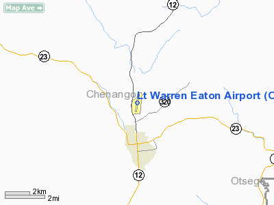
| Norwich Lt. Warren Eaton Airport |
 |
| IATA: OIC – ICAO: KOIC |
| Summary |
| Airport type |
Public |
| Operator |
Chenango County |
| Location |
Norwich, New York |
| Elevation AMSL |
1,025 ft / 312.4 m |
| Coordinates |
42°34′0″N 75°31′27″W / 42.566667°N 75.52417°W / 42.566667; -75.52417Coordinates: 42°34′0″N 75°31′27″W / 42.566667°N 75.52417°W / 42.566667; -75.52417 |
| Runways |
| Direction |
Length |
Surface |
| ft |
m |
| 1/19 |
4,724 |
1,440 |
Asphalt |
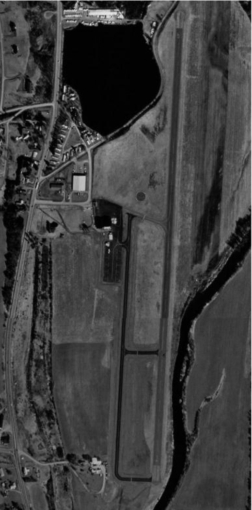
Norwich Lt. Warren Eaton Airport (IATA: OIC, ICAO: KOIC) is a small general aviation airport located two miles (3.2 km) north of the City of Norwich, in Chenango County, New York, USA. The airport covers 147 acres (59 ha) and has one runway. It has no scheduled commercial operations, but PrivatAir operates flights to Cincinnati for Procter & Gamble employees.
The above content comes from Wikipedia and is published under free licenses – click here to read more.
Location & QuickFacts
| FAA Information Effective: | 2008-09-25 |
| Airport Identifier: | OIC |
| Airport Status: | Operational |
| Longitude/Latitude: | 075-31-26.8020W/42-33-59.5950N
-75.524112/42.566554 (Estimated) |
| Elevation: | 1025 ft / 312.42 m (Surveyed) |
| Land: | 147 acres |
| From nearest city: | 2 nautical miles N of Norwich, NY |
| Location: | Chenango County, NY |
| Magnetic Variation: | 11W (1965) |
Owner & Manager
| Ownership: | Publicly owned |
| Owner: | Chenango Co/donald Macintosh |
| Address: | 5 Court St.
Norwich, NY 13815 |
| Phone number: | 607-337-1492 |
| Manager: | Jamie Baciuska |
| Address: | 6390 State Hwy 12
Norwich, NY 13815 |
| Phone number: | 800-800-4206
607-343-1624 |
Airport Operations and Facilities
| Airport Use: | Open to public |
| Wind indicator: | Yes |
| Segmented Circle: | Yes |
| Control Tower: | No |
| Lighting Schedule: | DUSK-DAWN
ACTVT HIRL RY 01/19; PAPI & REIL RYS 01 & 19 - CTAF. |
| Beacon Color: | Clear-Green (lighted land airport) |
| Landing fee charge: | No
OVERNIGHT TIE-DOWN FEE. |
| Sectional chart: | New York |
| Region: | AEA - Eastern |
| Boundary ARTCC: | ZBW - Boston |
| Tie-in FSS: | BUF - Buffalo |
| FSS on Airport: | No |
| FSS Toll Free: | 1-800-WX-BRIEF |
| NOTAMs Facility: | OIC (NOTAM-d service avaliable) |
| Federal Agreements: | NGY |
Airport Communications
| CTAF: | 122.800 |
| Unicom: | 122.800 |
Airport Services
| Fuel available: | 100LLA |
| Airframe Repair: | MAJOR |
| Power Plant Repair: | MAJOR |
| Bottled Oxygen: | LOW |
| Bulk Oxygen: | NONE |
Runway Information
Runway 01/19
| Dimension: | 4724 x 75 ft / 1439.9 x 22.9 m |
| Surface: | ASPH, Good Condition |
| Surface Treatment: | Saw-cut or plastic Grooved |
| Weight Limit: | Single wheel: 30000 lbs. |
| Edge Lights: | High |
| |
Runway 01 |
Runway 19 |
| Longitude: | 075-31-28.2270W | 075-31-25.3780W |
| Latitude: | 42-33-36.2870N | 42-34-22.9030N |
| Elevation: | 1010.00 ft | 1025.00 ft |
| Alignment: | 3 | 127 |
| Traffic Pattern: | Left | Left |
| Markings: | Non-precision instrument, Good Condition | Non-precision instrument, Fair Condition |
| Crossing Height: | 0.00 ft | 40.00 ft |
| Displaced threshold: | 0.00 ft | 440.00 ft |
| VASI: | 2-light PAPI on left side | 2-light PAPI on left side |
| Visual Glide Angle: | 0.00° | 3.75° |
| Runway End Identifier: | Yes | Yes |
| Obstruction: | 24 ft trees, 295.0 ft from runway, 52 ft left of centerline, 3:1 slope to clear | 96 ft trees, 1907.0 ft from runway, 67 ft right of centerline, 17:1 slope to clear
20:1 SLOPE TO DISPLACED THRESHOLD
RY 19, +24 FT TREES, 0 -200 FT FROM RY END, 200 FT R FROM C/L. |
|
Radio Navigation Aids
| ID |
Type |
Name |
Ch |
Freq |
Var |
Dist |
| CJY | NDB | Clay | | 275.00 | 12W | 31.4 nm |
| BK | NDB | Plein | | 329.00 | 12W | 39.5 nm |
| GSS | TACAN | Griffiss | 057X | | 12W | 40.3 nm |
| RKA | VOR/DME | Rockdale | 073X | 112.60 | 11W | 14.0 nm |
| HNK | VOR/DME | Hancock | 115X | 116.80 | 11W | 31.6 nm |
| DNY | VOR/DME | De Lancey | 058X | 112.10 | 11W | 34.3 nm |
| ITH | VOR/DME | Ithaca | 055X | 111.80 | 10W | 41.7 nm |
| GGT | VORTAC | Georgetown | 125X | 117.80 | 11W | 18.9 nm |
| UCA | VORTAC | Utica | 049X | 111.20 | 12W | 31.9 nm |
| CFB | VORTAC | Binghamton | 059X | 112.20 | 10W | 36.7 nm |
| SYR | VORTAC | Syracuse | 117X | 117.00 | 11W | 46.6 nm |
Remarks
- NUMEROUS MTNS PIERCE CONICAL SFC AROUND ARPT.
- SOUTH PARALLEL TWY NOT LGTD.
- RY 19 HAS 15 FT DROPOFF 30 FT FM THLD ON WEST SIDES.
- RY SAFETY AREAS HAVE DEPRESSIONS IN SFC.
- GEESE & DEER ON & INVOF ARPT.
- ARPT ESTABLISHED 6/17/52.
Images and information placed above are from
http://www.airport-data.com/airport/OIC/
We thank them for the data!
| General Info
|
| Country |
United States
|
| State |
NEW YORK
|
| FAA ID |
OIC
|
| Latitude |
42-33-59.595N
|
| Longitude |
075-31-26.802W
|
| Elevation |
1025 feet
|
| Near City |
NORWICH
|
We don't guarantee the information is fresh and accurate. The data may
be wrong or outdated.
For more up-to-date information please refer to other sources.
|
|


