 |
|
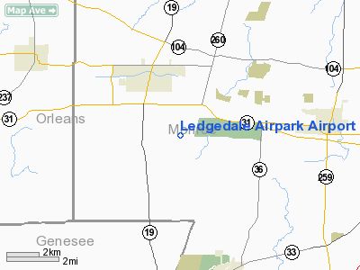
Ledgedale Airpark Airport |
| Ledgedale Airpark |
| IATA: none – ICAO: none – FAA LID: 7G0 |
| Summary |
| Airport type |
Public |
| Owner |
Big Fella Enterprizes Inc. |
| Serves |
Brockport, New York |
| Elevation AMSL |
665 ft / 203 m |
| Coordinates |
43°10′52.3″N 077°54′55.8″W / 43.181194°N 77.9155°W / 43.181194; -77.9155 |
| Runways |
| Direction |
Length |
Surface |
| ft |
m |
| 10/28 |
4,204 |
1,281 |
Asphalt |
| Statistics (2006) |
| Aircraft operations |
16,100 |
| Based aircraft |
40 |
| Source: Federal Aviation Administration |
Ledgedale Airpark is a public use airport in Monroe County, New York, United States. It is owned by Big Fella Enterprizes Inc. and is located three nautical miles (5.56 km) southwest of the central business district of the Village of Brockport. According to the FAA's National Plan of Integrated Airport Systems for 2007-2011, it is categorized as a reliever airport.
Although most U.S. airports use the same three-letter location identifier for the FAA and IATA, this airport is assigned 7G0 by the FAA but has no designation from the IATA.
Facilities and aircraft
Ledgedale Airpark covers an area of 166 acres (67.2 ha) at an elevation of 665 feet (203 m) above mean sea level. It has one runway designated 10/28 with an asphalt surface measuring 4,204 by 75 feet (1,281 x 23 m).
For the 12-month period ending August 18, 2006, the airport had 16,100 aircraft operations, an average of 44 per day: 96% general aviation and 4% military. At that time there were 40 aircraft based at this airport: 100% single-engine.
The above content comes from Wikipedia and is published under free licenses – click here to read more.
Location & QuickFacts
| FAA Information Effective: | 2008-09-25 |
| Airport Identifier: | 7G0 |
| Airport Status: | Operational |
| Longitude/Latitude: | 077-54-56.7500W/43-10-52.0500N
-77.915764/43.181125 (Estimated) |
| Elevation: | 666 ft / 203.00 m (Surveyed) |
| Land: | 166 acres |
| From nearest city: | 3 nautical miles SE of Brockport, NY |
| Location: | Monroe County, NY |
| Magnetic Variation: | 11W (1995) |
Owner & Manager
| Ownership: | Privately owned |
| Owner: | Big Fella Enterprizes Inc. |
| Address: | 2400 Colby St
Brockport, NY 14420 |
| Phone number: | 585-637-5050 |
| Manager: | Walt Eisenhauer |
| Address: | 2400 Colby St
Brockport, NY 14420 |
| Phone number: | 585-637-5050 |
Airport Operations and Facilities
| Airport Use: | Open to public |
| Wind indicator: | Yes |
| Segmented Circle: | No |
| Control Tower: | No |
| Lighting Schedule: | DUSK-DAWN
ACTVT MIRL RY 10/28; REIL, VASI RY 10 & PAPI RY 28 - 123.0. |
| Beacon Color: | Clear-Green (lighted land airport) |
| Sectional chart: | Detroit |
| Region: | AEA - Eastern |
| Boundary ARTCC: | ZOB - Cleveland |
| Tie-in FSS: | BUF - Buffalo |
| FSS on Airport: | No |
| FSS Toll Free: | 1-800-WX-BRIEF |
| NOTAMs Facility: | BUF (NOTAM-d service avaliable) |
| Federal Agreements: | NMY |
Airport Communications
| CTAF: | 122.700 |
| Unicom: | 122.700 |
Airport Services
| Fuel available: | 100LLA |
| Airframe Repair: | MAJOR |
| Power Plant Repair: | MAJOR |
| Bottled Oxygen: | NONE |
| Bulk Oxygen: | NONE |
Runway Information
Runway 10/28
| Dimension: | 4205 x 75 ft / 1281.7 x 22.9 m
RY 10/28 EXTDD WEST END. |
| Surface: | ASPH, Good Condition |
| Weight Limit: | Single wheel: 12000 lbs. |
| Edge Lights: | Medium |
| |
Runway 10 |
Runway 28 |
| Longitude: | 077-55-25.1100W | 077-54-28.3900W |
| Latitude: | 43-10-52.4300N | 43-10-51.6600N |
| Elevation: | 657.00 ft | 663.00 ft |
| Alignment: | 91 | 127 |
| Traffic Pattern: | Left | Left |
| Markings: | Non-precision instrument, Good Condition | Non-precision instrument, Good Condition |
| Crossing Height: | 36.00 ft | 20.00 ft |
| VASI: | 2-light PAPI on left side | 2-light PAPI on right side |
| Visual Glide Angle: | 4.00° | 4.00° |
| Runway End Identifier: | Yes | Yes |
| Obstruction: | 55 ft tree, 751.0 ft from runway, 250 ft left of centerline, 10:1 slope to clear
RWY 10, +6 FT ELECTRICAL BOXES 81 FT OUT AND 100 FT LEFT | 23 ft tree, 750.0 ft from runway, 90 ft left of centerline, 23:1 slope to clear |
|
Radio Navigation Aids
| ID |
Type |
Name |
Ch |
Freq |
Var |
Dist |
| AVN | NDB | Avon | | 344.00 | 09W | 12.1 nm |
| PYA | NDB | Penn Yan | | 260.00 | 12W | 49.7 nm |
| IAG | TACAN | Niagara Falls | 047X | | 10W | 46.0 nm |
| GEE | VOR/DME | Geneseo | 019X | 108.20 | 09W | 22.3 nm |
| BUF | VOR/DME | Buffalo | 111X | 116.40 | 08W | 35.5 nm |
| ROC | VORTAC | Rochester | 037X | 110.00 | 09W | 11.2 nm |
| BUF | VOT | Buffalo | | 109.00 | | 38.8 nm |
Remarks
Images and information placed above are from
http://www.airport-data.com/airport/7G0/
We thank them for the data!
| General Info
|
| Country |
United States
|
| State |
NEW YORK
|
| FAA ID |
7G0
|
| Latitude |
43-10-52.050N
|
| Longitude |
077-54-56.750W
|
| Elevation |
666 feet
|
| Near City |
BROCKPORT
|
We don't guarantee the information is fresh and accurate. The data may
be wrong or outdated.
For more up-to-date information please refer to other sources.
|
|


