 |
|
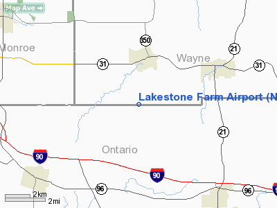
Location & QuickFacts
| FAA Information Effective: | 2008-09-25 |
| Airport Identifier: | NY11 |
| Airport Status: | Operational |
| Longitude/Latitude: | 077-18-28.9480W/43-02-07.2270N
-77.308041/43.035341 (Estimated) |
| Elevation: | 520 ft / 158.50 m (Estimated) |
| Land: | 25 acres |
| From nearest city: | 2 nautical miles S of Macedon, NY |
| Location: | Wayne County, NY |
| Magnetic Variation: | 11W (1985) |
Owner & Manager
| Ownership: | Privately owned |
| Owner: | John F. Ernest, Jr. |
| Address: | Canandaigua Road
Macedon, NY 14502 |
| Phone number: | 315-986-4054 |
| Address: |
|
Airport Operations and Facilities
| Airport Use: | Private |
| Wind indicator: | Yes |
| Segmented Circle: | No |
| Control Tower: | No |
| Landing fee charge: | No |
| Sectional chart: | Detroit |
| Region: | AEA - Eastern |
| Traffic Pattern Alt: | 1200 ft |
| Boundary ARTCC: | ZOB - Cleveland |
| Tie-in FSS: | BUF - Buffalo |
| FSS on Airport: | No |
| FSS Toll Free: | 1-800-WX-BRIEF |
Airport Communications
Airport Services
| Airframe Repair: | NONE |
| Power Plant Repair: | NONE |
Runway Information
Runway 18/36
| Dimension: | 2580 x 40 ft / 786.4 x 12.2 m |
| Surface: | TURF, Good Condition |
| |
Runway 18 |
Runway 36 |
| Traffic Pattern: | Left | Left |
| Obstruction: | 15 ft road, 60.0 ft from runway, 4:1 slope to clear
ROAD +15' W/TRUCK 60' FROM THR. | 70 ft tree, 860.0 ft from runway, 165 ft left of centerline, 13:1 slope to clear |
|
Radio Navigation Aids
| ID |
Type |
Name |
Ch |
Freq |
Var |
Dist |
| AVN | NDB | Avon | | 344.00 | 09W | 20.3 nm |
| PYA | NDB | Penn Yan | | 260.00 | 12W | 26.0 nm |
| GEE | VOR/DME | Geneseo | 019X | 108.20 | 09W | 22.3 nm |
| ITH | VOR/DME | Ithaca | 055X | 111.80 | 10W | 49.6 nm |
| ROC | VORTAC | Rochester | 037X | 110.00 | 09W | 16.9 nm |
| SYR | VORTAC | Syracuse | 117X | 117.00 | 11W | 49.0 nm |
Images and information placed above are from
http://www.airport-data.com/airport/NY11/
We thank them for the data!
| General Info
|
| Country |
United States
|
| State |
NEW YORK
|
| FAA ID |
NY11
|
| Latitude |
43-02-07.227N
|
| Longitude |
077-18-28.948W
|
| Elevation |
520 feet
|
| Near City |
MACEDON
|
We don't guarantee the information is fresh and accurate. The data may
be wrong or outdated.
For more up-to-date information please refer to other sources.
|
|


