 |
|
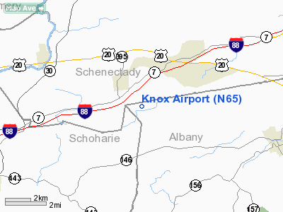
Location & QuickFacts
| FAA Information Effective: | 2008-09-25 |
| Airport Identifier: | N65 |
| Airport Status: | Operational |
| Longitude/Latitude: | 074-09-50.4610W/42-43-46.2720N
-74.164017/42.729520 (Estimated) |
| Elevation: | 1130 ft / 344.42 m (Estimated) |
| Land: | 0 acres |
| From nearest city: | 1 nautical miles SE of Quaker Street, NY |
| Location: | Albany County, NY |
| Magnetic Variation: | 14W (1985) |
Owner & Manager
| Ownership: | Privately owned |
| Owner: | Robert Rawlins |
| Address: | Po Box 131
Duanesburg, NY 12056 |
| Phone number: | 518-895-8140 |
| Manager: | Robert Rawlins |
| Address: | Chadwick Road
Delanson, NY 12053 |
| Phone number: | 518-895-8140 |
Airport Operations and Facilities
| Airport Use: | Open to public |
| Wind indicator: | Yes |
| Segmented Circle: | No |
| Control Tower: | No |
| Landing fee charge: | No |
| Sectional chart: | New York |
| Region: | AEA - Eastern |
| Traffic Pattern Alt: | 800 ft |
| Boundary ARTCC: | ZBW - Boston |
| Tie-in FSS: | BTV - Burlington |
| FSS on Airport: | No |
| FSS Toll Free: | 1-800-WX-BRIEF |
| NOTAMs Facility: | BTV (NOTAM-d service avaliable) |
Airport Communications
Airport Services
| Airframe Repair: | MAJOR |
| Power Plant Repair: | MAJOR |
Runway Information
Runway 09/27
| Dimension: | 2750 x 60 ft / 838.2 x 18.3 m |
| Surface: | TURF, Fair Condition |
| |
Runway 09 |
Runway 27 |
| Traffic Pattern: | Left | Right |
| Markings: | , | Nonstandard,
RY 27 THLD UNMKD. |
| Obstruction: | 50 ft tree, 50 ft left of centerline | 15 ft trees, 0.0 ft from runway, 75 ft left of centerline |
|
Radio Navigation Aids
| ID |
Type |
Name |
Ch |
Freq |
Var |
Dist |
| PSF | FAN MARKER | Abyss | | | 13W | 45.2 nm |
| HEU | NDB | Hunter | | 356.00 | 14W | 12.6 nm |
| JJH | NDB | Johnstown | | 523.00 | 14W | 17.8 nm |
| PFH | NDB | Philmont | | 272.00 | 13W | 34.7 nm |
| DXT | NDB | Dalton | | 370.00 | 15W | 46.6 nm |
| GBR | NDB | Great Barrington | | 395.00 | 14W | 47.1 nm |
| CAM | VOR/DME | Cambridge | 097X | 115.00 | 14W | 39.5 nm |
| DNY | VOR/DME | De Lancey | 058X | 112.10 | 11W | 48.3 nm |
| ALB | VORTAC | Albany | 100X | 115.30 | 13W | 16.0 nm |
| GFL | VORTAC | Glens Falls | 039X | 110.20 | 14W | 44.1 nm |
| UCA | VORTAC | Utica | 049X | 111.20 | 12W | 47.5 nm |
| ALB | VOT | Albany County | | 108.20 | | 15.1 nm |
Remarks
- PHONE 518-895-8140 FOR FIELD CONDITIONS.
- RY 09 HAS +30 FT MKD PLINE 30 FT FM RY END ON CNTRLN.
- RY 27 HAS 400 FT BY 26 FT MOWED OVRN/RUN-UP AREA AT SLIGHT ANGLE TO RY CNTRLN.
- PRVDD NSTD TFC PATS ARE ESTABD FOR THIS ARPT & NEARBY WANDERVOGEL ARPT; PRIOR TO INITIATING OPNS; CTC ALB ATCT TO DVLPS NSTD PATS.
Images and information placed above are from
http://www.airport-data.com/airport/N65/
We thank them for the data!
| General Info
|
| Country |
United States
|
| State |
NEW YORK
|
| FAA ID |
N65
|
| Latitude |
42-43-46.272N
|
| Longitude |
074-09-50.461W
|
| Elevation |
1130 feet
|
| Near City |
QUAKER STREET
|
We don't guarantee the information is fresh and accurate. The data may
be wrong or outdated.
For more up-to-date information please refer to other sources.
|
|


