 |
|
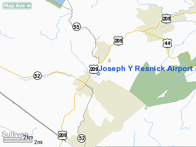
Location & QuickFacts
| FAA Information Effective: | 2008-09-25 |
| Airport Identifier: | N89 |
| Airport Status: | Operational |
| Longitude/Latitude: | 074-22-38.5530W/41-43-40.3360N
-74.377376/41.727871 (Estimated) |
| Elevation: | 292 ft / 89.00 m (Estimated) |
| Land: | 80 acres |
| From nearest city: | 1 nautical miles NE of Ellenville, NY |
| Location: | Ulster County, NY |
| Magnetic Variation: | 14W (2000) |
Owner & Manager
| Ownership: | Publicly owned |
| Owner: | Town Of Wawarsing |
| Address: | 108 Canal Street
Ellenville, NY 12428 |
| Phone number: | 845-647-6570 |
| Manager: | David Krom |
| Address: | 199 Airport Rd
Ellenville, NY 12428 |
| Phone number: | 845-647-8401 |
Airport Operations and Facilities
| Airport Use: | Open to public |
| Wind indicator: | Yes |
| Segmented Circle: | Yes |
| Control Tower: | No |
| Lighting Schedule: | DUSK-DAWN
ACTVT MIRL RY 04/22 - CTAF. |
| Beacon Color: | Clear-Green (lighted land airport) |
| Landing fee charge: | No |
| Sectional chart: | New York |
| Region: | AEA - Eastern |
| Boundary ARTCC: | ZBW - Boston |
| Responsible ARTCC: | ZNY - New York |
| Tie-in FSS: | ISP - New York |
| FSS on Airport: | No |
| FSS Toll Free: | 1-800-WX-BRIEF |
| NOTAMs Facility: | ISP (NOTAM-d service avaliable) |
| Federal Agreements: | NGY |
Airport Communications
| CTAF: | 122.800 |
| Unicom: | 122.800 |
Airport Services
| Fuel available: | 100LL |
| Airframe Repair: | NONE |
| Power Plant Repair: | NONE |
Runway Information
Runway 04/22
| Dimension: | 3838 x 75 ft / 1169.8 x 22.9 m |
| Surface: | ASPH, Good Condition |
| Edge Lights: | Medium |
| |
Runway 04 |
Runway 22 |
| Longitude: | 074-22-50.4030W | 074-22-22.7370W |
| Latitude: | 41-43-28.1070N | 41-43-59.8630N |
| Elevation: | 290.00 ft | 283.00 ft |
| Alignment: | 33 | 127 |
| Traffic Pattern: | Left | Right |
| Markings: | Non-precision instrument, Good Condition
MARKINGS FADING | Non-precision instrument, Good Condition
MARKINGS FADING |
| Displaced threshold: | 0.00 ft | 300.00 ft |
| VASI: | 2-light PAPI on left side | 2-light PAPI on left side |
| Runway End Identifier: | Yes | Yes |
| Obstruction: | 63 ft trees, 200.0 ft from runway, 185 ft left of centerline
+46 FT TREE, 0 FT DISTANCE FROM RWY THLD, 192 FT R. | 6 ft trees, 200.0 ft from runway
RY 22 APCH RATIO 0:1 TO DSPLCD THLD BASED ON +8 FT FENCE 243 FT LEFT OF DSPLCD THLD. RY 22 CLNC OBSTN IS CORN IN FIELD.
RWY 22 +30 FT TREE 180 FT RIGHT AND 60 FT FROM END OF RWY; -6 FT CREEK 0B 50 FT FROM END OF RWY. |
| Decleard distances: | Take off run available 3838.00 ft
Take off distance available 3838.00 ft
Actual stop distance available 3838.00 ft
Landing distance available 3538.00 ft
| Take off run available 3838.00 ft
Take off distance available 3838.00 ft
Actual stop distance available 3838.00 ft
Landing distance available 3538.00 ft
|
|
Radio Navigation Aids
| ID |
Type |
Name |
Ch |
Freq |
Var |
Dist |
| SKU | FAN MARKER | Stanwyck | | | 12W | 19.2 nm |
| SW | NDB | Neely | | 335.00 | 14W | 16.0 nm |
| SKU | NDB | Stanwyck | | 261.00 | 12W | 19.2 nm |
| PO | NDB | Meier | | 403.00 | 12W | 20.7 nm |
| MS | NDB | Monga | | 359.00 | 12W | 21.8 nm |
| PFH | NDB | Philmont | | 272.00 | 13W | 43.0 nm |
| PNJ | NDB | Paterson | | 347.00 | 12W | 48.1 nm |
| HUO | VOR/DME | Huguenot | 108X | 116.10 | 11W | 21.4 nm |
| IGN | VOR/DME | Kingston | 123X | 117.60 | 12W | 25.2 nm |
| PWL | VOR/DME | Pawling | 090X | 114.30 | 12W | 34.9 nm |
| DNY | VOR/DME | De Lancey | 058X | 112.10 | 11W | 37.5 nm |
| CMK | VOR/DME | Carmel | 113X | 116.60 | 12W | 44.8 nm |
| HNK | VOR/DME | Hancock | 115X | 116.80 | 11W | 46.6 nm |
| STW | VOR/DME | Stillwater | 033X | 109.60 | 11W | 49.3 nm |
| SAX | VORTAC | Sparta | 104X | 115.70 | 11W | 40.4 nm |
Remarks
-
- AVOID OVERFLIGHT OF HOSPITAL & SCHOOL BUILDINGS APPROX 1 MILE SW OF RY 22 & PRISON APPROX 1/2 MILE NE OF ARPT.
- DEER ON & INVOF ARPT.
- GLIDER ACTIVITY ON & INVOF ARPT.
- RY 04/22 PAEW MON-FRI 0700-1700.
- VFR USE ONLY
Images and information placed above are from
http://www.airport-data.com/airport/N89/
We thank them for the data!
| General Info
|
| Country |
United States
|
| State |
NEW YORK
|
| FAA ID |
N89
|
| Latitude |
41-43-40.336N
|
| Longitude |
074-22-38.553W
|
| Elevation |
292 feet
|
| Near City |
ELLENVILLE
|
We don't guarantee the information is fresh and accurate. The data may
be wrong or outdated.
For more up-to-date information please refer to other sources.
|
|


