|
 |
|
||||
|
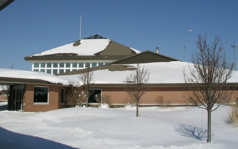
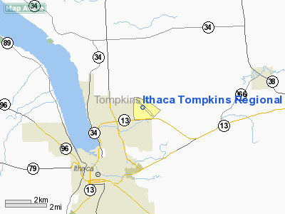
FAA diagram of Ithaca Tompkins Regional Airport (ITH) Ithaca Tompkins Regional Airport (IATA: ITH, ICAO: KITH, FAA LID: ITH) is a county-owned public-use airport three miles (5 km) northeast of the central business district of Ithaca, the county seat and largest city in Tompkins County, New York, United States. Situated near New York State Route 13, it serves the southern Finger Lakes Region. It is used for private as well as commercial passenger and freight aviation. For over 50 years, the airport has been home to the East Hill Flying Club which offers lessons and the use of seven small planes to its members. It is also the home of Taughannock Aviation which provides business jet charter and management as well as being the fixed base operator for the airport. HistoryThe original Ithaca Municipal Airport was located west of downtown Ithaca, near the inlet of Cayuga Lake. Its single short runway, proximity to the Lehigh Valley freight yards on the south side, the Cayuga Lake marshes on the north side, and fog in the lake valley posed serious limits to growth, however. Cornell University opened the existing airport on East Hill in 1948 and transferred its ownership to the County in 1956. The former airport site is now Cass Park, including a hangar which was renovated in 1975 to house the Hangar Theatre. The original airport was the base where aviation pioneer Cecil Robinson began flying aerial photography missions. In 1945 shortly after the end of World War II, he created Robinson Airlines, basing its maintenance operations at the airport. The airline changed its name to Mohawk Airlines in 1952 and merged with Allegheny Airlines in 1972. Later the airport was also served by Empire Airlines and Air North, the of latter which became Brockway Air, which was merged into Piedmont Airlines. Allegheny, Piedmont, and Empire were all eventually merged into US Airways. Other carriers that served the airport include Commuter Airlines, Mall Airways, Command Airways (later dba American Eagle), TW Express (also dba United Express), and Continental Express. In 1994 the runway was extended from 5,801 feet (1,768 m) in length to its present 6,601 feet (2,012 m) and an entirely new, 33,000 square foot (3,000 m²) terminal building opened, replacing the cramped, aging original building. The airport received its current name on March 20, 2001. The northwest-facing runway 32 is equipped with an instrument landing system approach and an associated medium intensity approach light system with runway alignment lights. Runway 14, facing southeast, has an instrument approach based on the VOR/DME located at the airport. A short turf runway was commissioned parallel to the paved runway, but during the 1980s another turf runway oriented north-south was available to the west of the terminal building and was approximately 1,802 feet (549 m) long and 100 feet (30 m) wide. Commercial traffic peaked in 1990 at 226,813 passengers , but by the end of the decade the small size of the market, relative proximity to Syracuse Hancock International Airport and other regional airports, and crowded conditions in Northeastern airspace had led Trans World Airlines, United Airlines, and finally Continental Airlines to seek more profitable routes, leaving US Airways the sole carrier. In late 2004, after negotiations with the County, Northwest Airlines agreed to add Northwest Airlink service to Detroit Metropolitan Wayne County Airport, which began on May 2, 2005. US Airways nonstop service to Pittsburgh, where it maintains focus city operations, resumed on November 9, 2005 but ceased again on April 1, 2006 due to low yield. Passenger traffic has improved with the additional service; the airport served about 140,000 passengers in 2004, increasing to around 170,000 in 2007 . On October 6, 2008, Continental Connection resumed service between Ithaca and Newark Liberty International Airport with four daily flights. Facilities and aircraftIthaca Tompkins Regional Airport covers an area of 531 acres (215 ha) which contains two runways: 14/32 with 6,601 x 150 ft (2,012 x 46 m) asphalt pavement and 15/33 with a 2,018 x 50 ft (615 x 15 m) turf surface. For the 12-month period ending October 31, 2006, the airport had 53,038 aircraft operations, an average of 145 per day: 77% general aviation, 20% scheduled commercial, 2% air taxi and <1% military. At that time there were 62 aircraft based at this airport: 68% single-engine, 15% multi-engine, 16% jet and 2% ultralight. Airlines and destinations
Ground transportationBusTCAT Route 32 travels to the Commons and Cornell University Monday through Friday, As of 2010, Route 72 serves the airport on weekends.. TaxiIthaca Dispatch (Cayuga, University,Yellow cab) operates a taxi stand at the airport, although it may be necessary to call in advance, especially during peak hours. Fares to and from the airport are standardized. Car and Limo ServiceIthaCar Service [1] Euro Sedans & Limousines [2] Right Limousine [3] The above content comes from Wikipedia and is published under free licenses – click here to read more.
Location & QuickFacts
Owner & Manager
Airport Operations and Facilities
Airport Communications
Airport Services
Runway InformationRunway 14/32
Runway 15/33
Radio Navigation Aids
Remarks
Images and information placed above are from We thank them for the data!
We don't guarantee the information is fresh and accurate. The data may
be wrong or outdated.
|
|||||||||||||||||||||||||||||||||||||||||||||||||||||||||||||||||||||||||||||||||||||||||||||||||||||||||||||||||||||||||||||||||||||||||||||||||||||||||||||||||||||||||||||||||||||||||||||||||||||||||||||||||||||||||||||||||||||||||||||||||||||||||||||||||||||||||||||||||||||||||||||||||||||||||||||||||||||||||||||||||||||||||||||||||||||||

 |
|
Copyright 2004-2026 © by Airports-Worldwide.com, Vyshenskoho st. 36, Lviv 79010, Ukraine Legal Disclaimer |