 |
|
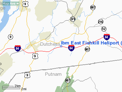
Ibm East Fishkill Heliport |
Location & QuickFacts
| FAA Information Effective: | 2008-09-25 |
| Airport Identifier: | 3NK3 |
| Airport Status: | Operational |
| Longitude/Latitude: | 073-50-01.4830W/41-32-01.3360N
-73.833745/41.533704 (Estimated) |
| Elevation: | 322 ft / 98.15 m (Estimated) |
| Land: | 0 acres |
| From nearest city: | 3 nautical miles S of Hopewell Junction, NY |
| Location: | Dutchess County, NY |
| Magnetic Variation: | 13W (1985) |
Owner & Manager
| Ownership: | Privately owned |
| Owner: | Ibm East Fishkill Facility |
| Address: | Rt 52
Hopewell Junction, NY 12533 |
| Phone number: | 914-894-9273 |
| Manager: | J. M. Hogan |
| Address: | Rt 52, 4a1 Dept 92c
Hopewell Junction, NY 12533 |
| Phone number: | 914-894-9273 |
Airport Operations and Facilities
| Airport Use: | Private |
| Segmented Circle: | No |
| Control Tower: | No |
| Landing fee charge: | No |
| Sectional chart: | New York |
| Region: | AEA - Eastern |
| Boundary ARTCC: | ZBW - Boston |
| Responsible ARTCC: | ZNY - New York |
| Tie-in FSS: | ISP - New York |
| FSS Toll Free: | 1-800-WX-BRIEF |
Runway Information
Helipad H1
| Dimension: | 75 x 75 ft / 22.9 x 22.9 m |
| Surface: | ASPH, |
| |
Runway H1 |
Runway |
| Traffic Pattern: | Left | Left |
|
Radio Navigation Aids
| ID |
Type |
Name |
Ch |
Freq |
Var |
Dist |
| SKU | FAN MARKER | Stanwyck | | | 12W | 9.5 nm |
| GBR | FAN MARKER | Sheffield | | | 13W | 41.5 nm |
| PO | NDB | Meier | | 403.00 | 12W | 6.4 nm |
| SKU | NDB | Stanwyck | | 261.00 | 12W | 9.5 nm |
| SW | NDB | Neely | | 335.00 | 14W | 18.0 nm |
| TBY | NDB | Waterbury | | 257.00 | 14W | 31.0 nm |
| PNJ | NDB | Paterson | | 347.00 | 12W | 38.1 nm |
| GBR | NDB | Great Barrington | | 395.00 | 14W | 43.5 nm |
| PFH | NDB | Philmont | | 272.00 | 13W | 43.5 nm |
| MMK | NDB | Meriden | | 238.00 | 14W | 45.3 nm |
| OP | NDB | Old Field Point Light | | 316.00 | 13W | 46.5 nm |
| MS | NDB | Monga | | 359.00 | 12W | 48.2 nm |
| IGN | VOR/DME | Kingston | 123X | 117.60 | 12W | 7.9 nm |
| PWL | VOR/DME | Pawling | 090X | 114.30 | 12W | 17.6 nm |
| CMK | VOR/DME | Carmel | 113X | 116.60 | 12W | 19.0 nm |
| HUO | VOR/DME | Huguenot | 108X | 116.10 | 11W | 34.9 nm |
| BDR | VOR/DME | Bridgeport | 25X | 108.80 | 12W | 39.1 nm |
| TEB | VOR/DME | Teterboro | 021X | 108.40 | 11W | 42.5 nm |
| LGA | VOR/DME | La Guardia | 078X | 113.10 | 12W | 44.9 nm |
| HVN | VOR/DME | New Haven | 035X | 109.80 | 13W | 45.8 nm |
| SAX | VORTAC | Sparta | 104X | 115.70 | 11W | 42.4 nm |
| BDR | VOT | Bridgeport | | 109.25 | | 39.0 nm |
Remarks
- DALGT VFR USE ONLY; WEATHER TWR AND WIRES ARE OBSTRUCTION MARKED, PILOTS ARE BRIEFED REGARDING PROCEDURES AND OBSTRUCTIONS.
Images and information placed above are from
http://www.airport-data.com/airport/3NK3/
We thank them for the data!
| General Info
|
| Country |
United States
|
| State |
NEW YORK
|
| FAA ID |
3NK3
|
| Latitude |
41-32-01.336N
|
| Longitude |
073-50-01.483W
|
| Elevation |
322 feet
|
| Near City |
HOPEWELL JUNCTION
|
We don't guarantee the information is fresh and accurate. The data may
be wrong or outdated.
For more up-to-date information please refer to other sources.
|
|


