 |
|
Location & QuickFacts
| FAA Information Effective: | 2008-09-25 |
| Airport Identifier: | 2NY2 |
| Airport Status: | Operational |
| Longitude/Latitude: | 074-19-59.4000W/41-20-58.8000N
-74.333167/41.349667 (Estimated) |
| Elevation: | 586 ft / 178.61 m () |
| Land: | 44 acres |
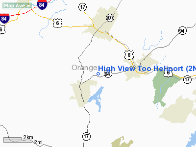
| From nearest city: | 3 nautical miles W of Chester, NY |
| Location: | Orange County, NY |
| Magnetic Variation: | () |
Owner & Manager
| Ownership: | Privately owned |
| Owner: | Nellie G. Dejong |
| Address: | 142 Clark Rd
Goshen, NY 10924 |
| Phone number: | 845-651-7740 |
| Manager: | Nellie G. Dejong |
| Address: | 142 Clark Rd
Goshen, NY 10924 |
| Phone number: | 518-796-9005 |
Airport Operations and Facilities
| Airport Use: | Private |
| Wind indicator: | Yes |
| Control Tower: | No |
| Sectional chart: | New York |
| Region: | AEA - Eastern |
| Boundary ARTCC: | ZNY - New York |
| Tie-in FSS: | ISP - New York |
| FSS Toll Free: | 1-800-WX-BRIEF |
Runway Information
Helipad H1
| Dimension: | 220 x 155 ft / 67.1 x 47.2 m |
| Surface: | TURF, |
| |
Runway H1 |
Runway |
| Traffic Pattern: | Left | Left |
|
Radio Navigation Aids
| ID |
Type |
Name |
Ch |
Freq |
Var |
Dist |
| SKU | FAN MARKER | Stanwyck | | | 12W | 16.8 nm |
| EWR | FAN MARKER | Maryann | | | 11W | 39.4 nm |
| SW | NDB | Neely | | 335.00 | 14W | 9.5 nm |
| SKU | NDB | Stanwyck | | 261.00 | 12W | 16.8 nm |
| PO | NDB | Meier | | 403.00 | 12W | 21.4 nm |
| PNJ | NDB | Paterson | | 347.00 | 12W | 25.6 nm |
| MS | NDB | Monga | | 359.00 | 12W | 34.5 nm |
| CAT | NDB | Chatham | | 254.00 | 11W | 36.9 nm |
| HUO | VOR/DME | Huguenot | 108X | 116.10 | 11W | 12.2 nm |
| IGN | VOR/DME | Kingston | 123X | 117.60 | 12W | 29.8 nm |
| STW | VOR/DME | Stillwater | 033X | 109.60 | 11W | 32.3 nm |
| TEB | VOR/DME | Teterboro | 021X | 108.40 | 11W | 32.5 nm |
| CMK | VOR/DME | Carmel | 113X | 116.60 | 12W | 34.2 nm |
| LGA | VOR/DME | La Guardia | 078X | 113.10 | 12W | 39.6 nm |
| BWZ | VOR/DME | Broadway | 089X | 114.20 | 11W | 39.9 nm |
| PWL | VOR/DME | Pawling | 090X | 114.30 | 12W | 41.5 nm |
| CRI | VOR/DME | Canarsie | 070X | 112.30 | 11W | 48.6 nm |
| SBJ | VOR/DME | Solberg | 076X | 112.90 | 10W | 49.7 nm |
| SAX | VORTAC | Sparta | 104X | 115.70 | 11W | 19.3 nm |
| JFK | VOT | Kennedy | | 115.10 | | 49.8 nm |
Remarks
- PRVDD VFR OPNS; PVT USE; AREA IS MARKED; AND WIND INDICATOR IS MAINTAINED.
Images and information placed above are from
http://www.airport-data.com/airport/2NY2/
We thank them for the data!
| General Info
|
| Country |
United States
|
| State |
NEW YORK
|
| FAA ID |
2NY2
|
| Latitude |
43-06-00.241N
|
| Longitude |
076-12-58.736W
|
| Elevation |
363 feet
|
| Near City |
SYRACUSE
|
We don't guarantee the information is fresh and accurate. The data may
be wrong or outdated.
For more up-to-date information please refer to other sources.
|
|


