 |
|
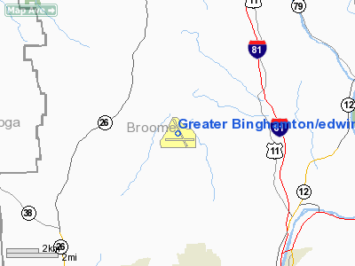
Greater Binghamton/edwin A Link Field Airport |
Greater Binghamton Airport
Edwin A. Link Field |
| IATA: BGM – ICAO: KBGM |
| Summary |
| Airport type |
Public |
| Operator |
Broome County |
| Location |
Binghamton, New York |
| Elevation AMSL |
1,636 ft / 498.7 m |
| Coordinates |
42°12′31″N 75°58′47″W / 42.20861°N 75.97972°W / 42.20861; -75.97972 |
| Runways |
| Direction |
Length |
Surface |
| ft |
m |
| 16/34 |
7,100 |
2,164 |
Asphalt |
| 10/28 |
5,002 |
1,525 |
Asphalt |
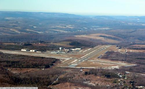
FAA diagram of Greater Binghamton Airport (BGM) Greater Binghamton Airport (IATA: BGM, ICAO: KBGM) is a medium-sized regional airport located in Maine, New York that serves the Southern Tier of New York, primarily Broome and Tioga counties.
The airport was originally named Broome County Airport and that name remained through the 1970s. It was later renamed to honor the inventor of the aircraft instrument simulator, the Link Trainer, as Edwin A. Link Field-Broome County Airport, a name it kept until the 1990s when it was again renamed to the Binghamton Regional Airport. The name Greater Binghamton Airport was chosen in 2003 to match the area's new marketing campaign under a unified name. The field on which the airport lies is still named in Link's honor. History
Up until World War II, Tri-Cities Airport in Endicott, New York had served as the primary airport of the Binghamton, New York region. Plane size increases and the demand for night-time flying caused this airport to become inadequate for the area's needs. Construction of a new airport on Mount Ettrick in Maine, New York began in 1945, and concluded in 1951 when the airport was opened.
The main runway which is oriented north northwest-south southeast was 5,600 feet in length initially, but was later extended by about 700 feet to the south to 6,298 feet in 1969. In 1988 the main runway was extended again, this time on the north end, to 7,500 feet (2,286 m). The crosswind east-west runway is 5002 feet long.
During the 1980s, the airport was a hub for the commuter airline Brockway Air, which operated a fleet of Fokker F-27 and Beechcraft 1900 tuboprop aircraft. The airline ran flights to regional destinations like Rochester and Buffalo, and to business centers such as New York and Boston. Brockway Air later became a Piedmont Airlines affiliate carrier, and later a TWA affiliate carrier.
In recent years, the main runway was shortened to 7,100 feet to add engineered materials arrestor beds to both ends of the runway. The arrestor beds - better known as Engineered Material Arresting Systems, or EMAS - are a crushable concrete surface that slows an aircraft in the event of an overrun. Given that the airport was built on a mountaintop, the terrain drops off abruptly shortly after the runway ends, prompting the need for the EMAS beds. Fifty years after its opening, the airport finally received a major renovation in 2001. In July 2004 the airport opened four new jet bridges that can accommodate regional and mainline jets. Currently, the airport is undergoing an improvement project to extend Taxiway Alpha the full length of Runway 16-34.
Before the regional jets took over the commuter market, US Airways (previously USAir) frequently operated DC-9's, Boeing 737's, and Fokker Jets out of BGM servicing Pittsburgh International Airport and the surrounding regional airports.
Airlines and destinations
| Airlines |
Destinations |
| Delta Connection operated by Pinnacle Airlines |
Detroit |
| United Express operated by Colgan Air |
Washington-Dulles |
| US Airways Express operated by Air Wisconsin |
Philadelphia |
| US Airways Express operated by Piedmont Airlines |
Philadelphia |
The above content comes from Wikipedia and is published under free licenses – click here to read more.
 |
(Click on the photo to enlarge) |
Location & QuickFacts
| FAA Information Effective: | 2008-09-25 |
| Airport Identifier: | BGM |
| Airport Status: | Operational |
| Longitude/Latitude: | 075-58-47.4240W/42-12-31.2780N
-75.979840/42.208688 (Estimated) |
| Elevation: | 1636 ft / 498.65 m (Surveyed) |
| Land: | 1199 acres |
| From nearest city: | 7 nautical miles N of Binghamton, NY |
| Location: | Broome County, NY |
| Magnetic Variation: | 12W (1995) |
Owner & Manager
| Ownership: | Publicly owned |
| Owner: | Broome County |
| Address: | 2534 Airport Road Box 16
Johnson City, NY 13790 |
| Phone number: | 607-763-4471 |
| Manager: | Carl R. Beardsley Jr. |
| Address: | 2534 Airport Road, Box 16
Johnson City, NY 13790 |
| Phone number: | 607-763-4471 |
Airport Operations and Facilities
| Airport Use: | Open to public |
| Wind indicator: | Yes |
| Segmented Circle: | No |
| Control Tower: | Yes |
| Lighting Schedule: | DUSK-DAWN
WHEN ATCT CLSD ACTVT HIRL RY 16/34; MIRL RY 10/28; MALSR RYS 16 & 34 & TWY LGTS - CTAF. |
| Beacon Color: | Clear-Green (lighted land airport) |
| Landing fee charge: | Yes
LNDG FEE FOR MULTI-ENGINE & TURBINE ACFT OVER 4000 LBS. US CUSTOMS USER FEE ARPT. |
| Sectional chart: | New York |
| Region: | AEA - Eastern |
| Traffic Pattern Alt: | 800 ft |
| Boundary ARTCC: | ZNY - New York |
| Tie-in FSS: | BUF - Buffalo |
| FSS on Airport: | No |
| FSS Toll Free: | 1-800-WX-BRIEF |
| NOTAMs Facility: | BGM (NOTAM-d service avaliable) |
| Certification type/date: | I B S 05/1973
PPR 12 HRS FOR UNSKED ACFT OPNS WITH MORE THAN 9 PSGR SEATS 2300-0600 CALL AMGR 607-763-4474. ARFF AVBL 0515-0045 AND/OR UNTIL 15 MIN AFTER THE LAST SKED AIR CARRIER OR COMMUTER. |
| Federal Agreements: | NGY |
Airport Communications
| CTAF: | 119.300 |
| Unicom: | 122.950 |
Airport Services
| Fuel available: | 100LLA |
| Airframe Repair: | MINOR |
| Power Plant Repair: | MINOR |
| Bottled Oxygen: | HIGH/LOW |
| Bulk Oxygen: | NONE |
Runway Information
Runway 10/28
| Dimension: | 5002 x 150 ft / 1524.6 x 45.7 m |
| Surface: | ASPH, Good Condition |
| Surface Treatment: | Saw-cut or plastic Grooved |
| Weight Limit: | Single wheel: 98000 lbs.
Dual wheel: 125000 lbs.
Dual tandem wheel: 187000 lbs. |
| Edge Lights: | Medium |
| |
Runway 10 |
Runway 28 |
| Longitude: | 075-59-19.9711W | 075-58-13.6416W |
| Latitude: | 42-12-18.1779N | 42-12-21.1436N |
| Elevation: | 1591.00 ft | 1572.00 ft |
| Alignment: | 86 | 127 |
| Traffic Pattern: | Left | Left |
| Markings: | Non-precision instrument, Good Condition | Non-precision instrument, Good Condition |
| Crossing Height: | 55.00 ft | 45.00 ft |
| VASI: | 4-box on left side | 4-box on left side |
| Visual Glide Angle: | 3.00° | 3.00° |
| Runway End Identifier: | No | Yes |
| Decleard distances: | Take off run available 5002.00 ft
Take off distance available 5002.00 ft
Actual stop distance available 5002.00 ft
Landing distance available 5002.00 ft
| Take off run available 5002.00 ft
Take off distance available 5002.00 ft
Actual stop distance available 5002.00 ft
Landing distance available 5002.00 ft
|
|
Runway 16/34
| Dimension: | 7100 x 150 ft / 2164.1 x 45.7 m |
| Surface: | ASPH, Good Condition |
| Surface Treatment: | Saw-cut or plastic Grooved |
| Weight Limit: | Single wheel: 98000 lbs.
Dual wheel: 125000 lbs.
Dual tandem wheel: 187000 lbs. |
| Edge Lights: | High |
| |
Runway 16 |
Runway 34 |
| Longitude: | 075-59-12.6273W | 075-58-23.0880W |
| Latitude: | 42-13-09.2918N | 42-12-09.6160N |
| Elevation: | 1636.00 ft | 1569.00 ft |
| Alignment: | 127 | 127 |
| ILS Type: | ILS
| ILS
|
| Traffic Pattern: | Left | Left |
| Markings: | Precision instrument, Good Condition | Precision instrument, Good Condition |
| Crossing Height: | 52.00 ft | 44.00 ft |
| Displaced threshold: | 401.00 ft | 0.00 ft |
| VASI: | 2-light PAPI on left side | 2-light PAPI on left side |
| Visual Glide Angle: | 3.00° | 3.00° |
| RVR Equipment: | | touchdown |
| Approach lights: | MALSR | MALSR |
| Obstruction: | 7 ft ant, 225.0 ft from runway, 250 ft left of centerline, 3:1 slope to clear | , 50:1 slope to clear |
| Decleard distances: | Take off run available 7100.00 ft
Take off distance available 7100.00 ft
Actual stop distance available 7100.00 ft
Landing distance available 6699.00 ft
| Take off run available 7100.00 ft
Take off distance available 7100.00 ft
Actual stop distance available 7100.00 ft
Landing distance available 7100.00 ft
|
|
Radio Navigation Aids
| ID |
Type |
Name |
Ch |
Freq |
Var |
Dist |
| ALP | NDB | Alpine | | 245.00 | 12W | 34.9 nm |
| ITH | VOR/DME | Ithaca | 055X | 111.80 | 10W | 27.4 nm |
| HNK | VOR/DME | Hancock | 115X | 116.80 | 11W | 30.8 nm |
| RKA | VOR/DME | Rockdale | 073X | 112.60 | 11W | 36.4 nm |
| DNY | VOR/DME | De Lancey | 058X | 112.10 | 11W | 45.6 nm |
| ULW | VOR/DME | Elmira | 033Y | 109.65 | 12W | 47.1 nm |
| CFB | VORTAC | Binghamton | 059X | 112.20 | 10W | 7.6 nm |
| GGT | VORTAC | Georgetown | 125X | 117.80 | 11W | 35.5 nm |
| LHY | VORTAC | Lake Henry | 045X | 110.80 | 10W | 49.4 nm |
Remarks
- ATCT UNABLE TO SEE HARD SFC W OF MAINT BLDG.
- EXTENSIVE GLIDER ACTIVITY 10 NM SW OF ARPT.
- TURBINE ENGINE POWERED ACFT OPERATED UNDER FAR 121.189 & 135.379 ARE ADVISED THAT CLNC DSTCS MAY NOT BE ADEQUATE FOR TKOF WHEN ACFT ARE HOLDING ON TWYS B-C-D-F & J FOR RY 16/34 & TWY P FOR RY 10/28.
- BIRD ACTIVITY ON AND INVOF ARPT.
- LGTD STRUCTURE 118 FT AGL 2000 FT SOUTH OF AER 10.
- ENGINEERED MATERIALS ARRESTING SYSTEM 315 FT BY 161 FT LCTD AT DEP END RY 16.
- ENGINEERED MATERIALS ARRESTING SYSTEM 311 FT BY 161 FT LCTD AT DEP END RY 34.
Images and information placed above are from
http://www.airport-data.com/airport/BGM/
We thank them for the data!
| General Info
|
| Country |
United States
|
| State |
NEW YORK
|
| FAA ID |
BGM
|
| Latitude |
42-12-30.500N
|
| Longitude |
075-58-46.600W
|
| Elevation |
1636 feet
|
| Near City |
BINGHAMTON
|
We don't guarantee the information is fresh and accurate. The data may
be wrong or outdated.
For more up-to-date information please refer to other sources.
|
|


