 |
|
| Genesee County Airport |
| IATA: none – ICAO: KGVQ – FAA LID: GVQ |
| Summary |
| Airport type |
Public |
| Owner |
Genesee County |
| Operator |
Genesee County Highway Department |
| Serves |
Batavia, New York |
| Elevation AMSL |
914 ft / 279 m |
| Coordinates |
43°01′54″N 078°10′11″W / 43.03167°N 78.16972°W / 43.03167; -78.16972 |
| Website |
www.co.genesee.ny.us/... |
| Runways |
| Direction |
Length |
Surface |
| ft |
m |
| 10/28 |
5,500 |
1,676 |
Asphalt |
| Statistics (2009) |
| Aircraft operations |
40,000 |
| Based aircraft |
48 |
| Source: Federal Aviation Administration |
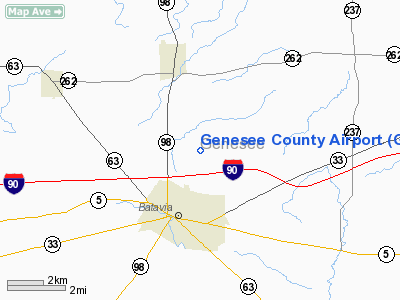
Genesee County Airport (ICAO: KGVQ, FAA LID: GVQ) is a county-owned, public-use airport located two nautical miles (3.7 km) north of the central business district of Batavia, a city in Genesee County, New York, United States. According to the FAA's National Plan of Integrated Airport Systems for 2009–2013, it is classified as a reliever airport.
Although many U.S. airports use the same three-letter location identifier for the FAA and IATA, this airport is assigned GVQ by the FAA but has no designation from the IATA. Facilities and aircraft
Genesee County Airport covers an area of 326 acres (132 ha) at an elevation of 914 feet (279 m) above mean sea level. It has one runway designated 10/28 with an asphalt surface measuring 5,500 by 100 feet (1,676 x 30 m).
For the 12-month period ending September 18, 2009, the airport had 40,000 aircraft operations, an average of 109 per day: 96% general aviation, 2% air taxi, and 2% military. At that time there were 48 aircraft based at this airport: 85% single-engine, 4% multi-engine, 6% jet and 4% helicopter.
Nearby airports
Nearby airports with instrument approach procedures:
- 9G6 - Pine Hill Airport (10 nm NW)
- 5G0 - Le Roy Airport (11 nm E)
- 9G3 - Akron Airport (14 nm W)
- 7G0 - Ledgedale Airpark (14 nm NE)
- ROC - Greater Rochester International Airport (22 nm E)
The above content comes from Wikipedia and is published under free licenses – click here to read more.
Location & QuickFacts
| FAA Information Effective: | 2008-09-25 |
| Airport Identifier: | GVQ |
| Airport Status: | Operational |
| Longitude/Latitude: | 078-10-10.7610W/43-01-54.3230N
-78.169656/43.031756 (Estimated) |
| Elevation: | 913 ft / 278.28 m (Surveyed) |
| Land: | 326 acres |
| From nearest city: | 2 nautical miles N of Batavia, NY |
| Location: | Genesee County, NY |
| Magnetic Variation: | 11W (2000) |
Owner & Manager
| Ownership: | Publicly owned |
| Owner: | Mr. Timothy Hens |
| Address: | Genesee Co. Supt. Of Hwy., 153 Cedar Street
Batavia, NY 14020 |
| Phone number: | 585-344-8508 |
| Manager: | Jason Long |
| Address: | Genesee Co. Supt. Of Hwy., 153 Cedar Street
Batavia, NY 14020 |
| Phone number: | 585-344-8532
CALL ARPT AT 716-344-8532 DURING ATTENDED HOURS. |
Airport Operations and Facilities
| Airport Use: | Open to public |
| Wind indicator: | Yes |
| Segmented Circle: | Yes |
| Control Tower: | No |
| Lighting Schedule: | DUSK-DAWN
ACTVT HIRL RY 10/28; PAPI RYS 10 & 28; REIL RYS 10 & 28; MALSR RY 28 - CTAF. |
| Beacon Color: | Clear-Green (lighted land airport) |
| Landing fee charge: | No |
| Sectional chart: | Detroit |
| Region: | AEA - Eastern |
| Traffic Pattern Alt: | 1000 ft |
| Boundary ARTCC: | ZOB - Cleveland |
| Tie-in FSS: | BUF - Buffalo |
| FSS on Airport: | No |
| FSS Toll Free: | 1-800-WX-BRIEF |
| NOTAMs Facility: | GVQ (NOTAM-d service avaliable) |
| Federal Agreements: | NGY |
Airport Communications
| CTAF: | 122.700 |
| Unicom: | 122.700 |
Airport Services
| Fuel available: | 100LLA1+ |
| Airframe Repair: | MAJOR |
| Power Plant Repair: | MAJOR |
| Bottled Oxygen: | NONE |
| Bulk Oxygen: | HIGH |
Runway Information
Runway 10/28
| Dimension: | 5500 x 100 ft / 1676.4 x 30.5 m |
| Surface: | ASPH, Good Condition |
| Weight Limit: | Single wheel: 21000 lbs.
Dual wheel: 33000 lbs. |
| Edge Lights: | High |
| |
Runway 10 |
Runway 28 |
| Longitude: | 078-10-47.7820W | 078-09-33.7400W |
| Latitude: | 43-01-54.7060N | 43-01-53.9400N |
| Elevation: | 912.00 ft | 911.00 ft |
| Alignment: | 91 | 127 |
| ILS Type: | | ILS
|
| Traffic Pattern: | Left | Left |
| Markings: | Non-precision instrument, Good Condition | Precision instrument, Good Condition |
| Crossing Height: | 0.00 ft | 43.00 ft |
| VASI: | 2-light PAPI on left side | 2-light PAPI on left side |
| Visual Glide Angle: | 0.00° | 3.00° |
| Approach lights: | | MALSR |
| Runway End Identifier: | Yes | Yes
RWY 28 REILS IS OTS INDEFLY |
| Obstruction: | 6 ft fence, 200.0 ft from runway, 460 ft right of centerline
+6 FT FENCE AT 460 FT FM CENTERLINE. | |
|
Radio Navigation Aids
| ID |
Type |
Name |
Ch |
Freq |
Var |
Dist |
| AVN | NDB | Avon | | 344.00 | 09W | 17.6 nm |
| LYS | NDB | Olean | | 360.00 | 09W | 45.6 nm |
| SN | NDB | St Catherines | | 408.00 | 01E | 48.1 nm |
| IAG | TACAN | Niagara Falls | 047X | | 10W | 35.1 nm |
| BUF | VOR/DME | Buffalo | 111X | 116.40 | 08W | 21.9 nm |
| GEE | VOR/DME | Geneseo | 019X | 108.20 | 09W | 22.6 nm |
| ROC | VORTAC | Rochester | 037X | 110.00 | 09W | 22.4 nm |
| BUF | VOT | Buffalo | | 109.00 | | 25.4 nm |
Remarks
- RWY 10: +5' BERM 220' LEFT, WITHIN SIDE PRIMARY SURFACE (1597'-1997' DOWN RWY)
- EXISTED PRIOR TO 1959.
Images and information placed above are from
http://www.airport-data.com/airport/GVQ/
We thank them for the data!
| General Info
|
| Country |
United States
|
| State |
NEW YORK
|
| FAA ID |
GVQ
|
| Latitude |
43-01-54.215N
|
| Longitude |
078-10-03.359W
|
| Elevation |
913 feet
|
| Near City |
BATAVIA
|
We don't guarantee the information is fresh and accurate. The data may
be wrong or outdated.
For more up-to-date information please refer to other sources.
|
|


