 |
|
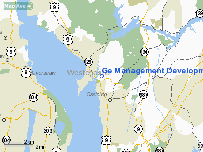
Ge Management Development Institute Heliport |
Location & QuickFacts
| FAA Information Effective: | 2008-09-25 |
| Airport Identifier: | NK78 |
| Airport Status: | Operational |
| Longitude/Latitude: | 073-52-04.4890W/41-11-20.3410N
-73.867914/41.188984 (Estimated) |
| Elevation: | 181 ft / 55.17 m (Estimated) |
| Land: | 0 acres |
| From nearest city: | 1 nautical miles N of Ossining, NY |
| Location: | Westchester County, NY |
| Magnetic Variation: | 13W (1984) |
Owner & Manager
| Ownership: | Privately owned |
| Owner: | General Electric Company |
| Address: | Old Albany Post Rd
Ossining, NY 10562 |
| Phone number: | 914-944-2452 |
| Manager: | Michael D. Blewitt |
| Address: | Old Albany Post Rd
Ossining, NY 10562 |
| Phone number: | 914-944-2452 |
Airport Operations and Facilities
| Airport Use: | Private |
| Wind indicator: | Yes |
| Segmented Circle: | No |
| Control Tower: | No |
| Landing fee charge: | No |
| Sectional chart: | New York |
| Region: | AEA - Eastern |
| Boundary ARTCC: | ZNY - New York |
| Tie-in FSS: | ISP - New York |
| FSS on Airport: | No |
| FSS Toll Free: | 1-800-WX-BRIEF |
Runway Information
Helipad H1
| Dimension: | 44 x 44 ft / 13.4 x 13.4 m |
| Surface: | ASPH, |
| |
Runway H1 |
Runway |
| Traffic Pattern: | Left | Left |
|
Radio Navigation Aids
| ID |
Type |
Name |
Ch |
Freq |
Var |
Dist |
| SKU | FAN MARKER | Stanwyck | | | 12W | 21.9 nm |
| EWR | FAN MARKER | Maryann | | | 11W | 32.6 nm |
| PNJ | NDB | Paterson | | 347.00 | 12W | 19.4 nm |
| SKU | NDB | Stanwyck | | 261.00 | 12W | 21.9 nm |
| PO | NDB | Meier | | 403.00 | 12W | 23.6 nm |
| SW | NDB | Neely | | 335.00 | 14W | 24.1 nm |
| OP | NDB | Old Field Point Light | | 316.00 | 13W | 36.3 nm |
| CAT | NDB | Chatham | | 254.00 | 11W | 37.1 nm |
| OGY | NDB | Bridge | | 414.00 | 12W | 37.3 nm |
| BBN | NDB | Babylon | | 275.00 | 14W | 38.0 nm |
| TBY | NDB | Waterbury | | 257.00 | 14W | 38.5 nm |
| CMK | VOR/DME | Carmel | 113X | 116.60 | 12W | 14.1 nm |
| TEB | VOR/DME | Teterboro | 021X | 108.40 | 11W | 22.3 nm |
| LGA | VOR/DME | La Guardia | 078X | 113.10 | 12W | 24.1 nm |
| IGN | VOR/DME | Kingston | 123X | 117.60 | 12W | 28.7 nm |
| BDR | VOR/DME | Bridgeport | 25X | 108.80 | 12W | 33.7 nm |
| JFK | VOR/DME | Kennedy | 106X | 115.90 | 12W | 33.7 nm |
| CRI | VOR/DME | Canarsie | 070X | 112.30 | 11W | 34.7 nm |
| DPK | VOR/DME | Deer Park | 124X | 117.70 | 12W | 35.0 nm |
| HUO | VOR/DME | Huguenot | 108X | 116.10 | 11W | 35.3 nm |
| PWL | VOR/DME | Pawling | 090X | 114.30 | 12W | 36.9 nm |
| HVN | VOR/DME | New Haven | 035X | 109.80 | 13W | 44.6 nm |
| STW | VOR/DME | Stillwater | 033X | 109.60 | 11W | 46.8 nm |
| BWZ | VOR/DME | Broadway | 089X | 114.20 | 11W | 49.2 nm |
| SAX | VORTAC | Sparta | 104X | 115.70 | 11W | 31.2 nm |
| JFK | VOT | Kennedy | | 115.10 | | 33.6 nm |
| BDR | VOT | Bridgeport | | 109.25 | | 33.6 nm |
| ISP | VOT | Long Island Mac Arthur | | 109.40 | | 42.5 nm |
Remarks
- PROVIDED USERS ARE FAMILIARIZED WITH APP/DEP PATHS; APP/DEP PATH TO THE EAST BE CHECKED FOR CONFORMANCE WITH OBSTRUCTION REQUIREMENTS FOR FAR PART 77; IF NIGHT OPEREATIONS, SITE BE LIGHTED IN ACCORDANCE WITH AC150/5390-1B.
Images and information placed above are from
http://www.airport-data.com/airport/NK78/
We thank them for the data!
| General Info
|
| Country |
United States
|
| State |
NEW YORK
|
| FAA ID |
NK78
|
| Latitude |
41-11-20.341N
|
| Longitude |
073-52-04.489W
|
| Elevation |
181 feet
|
| Near City |
OSSINING
|
We don't guarantee the information is fresh and accurate. The data may
be wrong or outdated.
For more up-to-date information please refer to other sources.
|
|


