 |
|
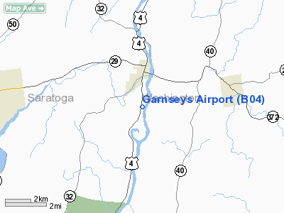
Location & QuickFacts
| FAA Information Effective: | 2008-09-25 |
| Airport Identifier: | B04 |
| Airport Status: | Operational |
| Longitude/Latitude: | 073-34-58.4170W/43-04-30.2720N
-73.582894/43.075076 (Estimated) |
| Elevation: | 100 ft / 30.48 m (Estimated) |
| Land: | 15 acres |
| From nearest city: | 1 nautical miles S of Schuylerville, NY |
| Location: | Saratoga County, NY |
| Magnetic Variation: | 14W (1985) |
Owner & Manager
| Ownership: | Privately owned |
| Owner: | Paul Garnsey |
| Address: | 952 Rt 4 South
Schuylerville, NY 12871 |
| Phone number: | 518-695-3346 |
| Manager: | Zene Garnsey |
| Address: | 952 Rt 4 South
Schuylerville, NY 12871 |
| Phone number: | 518-695-3346 |
Airport Operations and Facilities
| Airport Use: | Open to public |
| Wind indicator: | Yes |
| Segmented Circle: | No |
| Control Tower: | No |
| Landing fee charge: | No |
| Sectional chart: | New York |
| Region: | AEA - Eastern |
| Boundary ARTCC: | ZBW - Boston |
| Tie-in FSS: | BTV - Burlington |
| FSS on Airport: | No |
| FSS Toll Free: | 1-800-WX-BRIEF |
| NOTAMs Facility: | BTV (NOTAM-d service avaliable) |
Airport Communications
Airport Services
| Airframe Repair: | NONE |
| Power Plant Repair: | NONE |
Runway Information
Runway 02/20
| Dimension: | 2600 x 103 ft / 792.5 x 31.4 m |
| Surface: | TURF, Good Condition |
| |
Runway 02 |
Runway 20 |
| Traffic Pattern: | Left | Left |
| Obstruction: | 30 ft tree, 90 ft right of centerline | 10 ft road, 10.0 ft from runway, 1:1 slope to clear |
|
Runway 02W/20W
| Dimension: | 9999 x 750 ft / 3047.7 x 228.6 m |
| Surface: | WATER, |
| |
Runway 02W |
Runway 20W |
| Traffic Pattern: | Left | Left |
|
Radio Navigation Aids
| ID |
Type |
Name |
Ch |
Freq |
Var |
Dist |
| PSF | FAN MARKER | Abyss | | | 13W | 40.6 nm |
| R | FAN MARKER | Chitt | | | 14W | 43.0 nm |
| HEU | NDB | Hunter | | 356.00 | 14W | 20.4 nm |
| VWD | NDB | Mount Snow | | 224.00 | 15W | 32.8 nm |
| JJH | NDB | Johnstown | | 523.00 | 14W | 33.2 nm |
| DXT | NDB | Dalton | | 370.00 | 15W | 40.6 nm |
| SXD | NDB | Springfield | | 265.00 | 15W | 45.2 nm |
| DYO | NDB | Smuto | | 221.00 | 15W | 46.8 nm |
| PFH | NDB | Philmont | | 272.00 | 13W | 49.8 nm |
| CAM | VOR/DME | Cambridge | 097X | 115.00 | 14W | 11.6 nm |
| RUT | VOR/DME | Rutland | 47X | 111.00 | 15W | 38.7 nm |
| GFL | VORTAC | Glens Falls | 039X | 110.20 | 14W | 16.1 nm |
| ALB | VORTAC | Albany | 100X | 115.30 | 13W | 22.0 nm |
| ALB | VOT | Albany County | | 108.20 | | 22.6 nm |
Remarks
- TURF STRIP MAY BE SOFT IN SPRING.
- RY 20 HAS 4 1/2 FT FENCE 60 FT FM RY END BOTH SIDES & NUMEROUS BLDG IN APCH TO RY 20.
- ARPT OPEN DALGT HRS ONLY.
- EXISTED PRIOR TO 1959.
Images and information placed above are from
http://www.airport-data.com/airport/B04/
We thank them for the data!
| General Info
|
| Country |
United States
|
| State |
NEW YORK
|
| FAA ID |
B04
|
| Latitude |
43-04-30.272N
|
| Longitude |
073-34-58.417W
|
| Elevation |
100 feet
|
| Near City |
SCHUYLERVILLE
|
We don't guarantee the information is fresh and accurate. The data may
be wrong or outdated.
For more up-to-date information please refer to other sources.
|
|


