 |
|
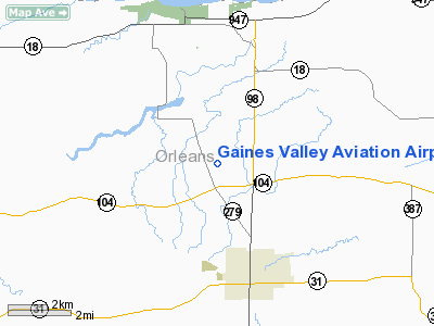
Gaines Valley Aviation Airport |
Location & QuickFacts
| FAA Information Effective: | 2008-09-25 |
| Airport Identifier: | NY06 |
| Airport Status: | Operational |
| Longitude/Latitude: | 078-12-50.0770W/43-17-47.2090N
-78.213910/43.296447 (Estimated) |
| Elevation: | 380 ft / 115.82 m (Estimated) |
| Land: | 50 acres |
| From nearest city: | 5 nautical miles N of Albion, NY |
| Location: | Orleans County, NY |
| Magnetic Variation: | 10W (1985) |
Owner & Manager
| Ownership: | Privately owned |
| Owner: | Gaine Valley Aviation Inc |
| Address: | Gaines Waterpord Road
Albion, NY 14411 |
| Phone number: | 716-589-1330 |
| Manager: | Clark Rath |
| Address: | Road 1
Waterport, NY 14571 |
| Phone number: | 716-589-1330 |
Airport Operations and Facilities
| Airport Use: | Private |
| Wind indicator: | Yes |
| Segmented Circle: | Yes |
| Control Tower: | No |
| Lighting Schedule: | RDO-CTL
ACTVT LIRL RY 09/27 - 122.8. |
| Sectional chart: | Detroit |
| Region: | AEA - Eastern |
| Boundary ARTCC: | ZOB - Cleveland |
| Tie-in FSS: | BUF - Buffalo |
| FSS Toll Free: | 1-800-WX-BRIEF |
Airport Communications
Runway Information
Runway 09/27
| Dimension: | 4000 x 90 ft / 1219.2 x 27.4 m |
| Surface: | TURF, Good Condition |
| Edge Lights: | Low |
| |
Runway 09 |
Runway 27 |
| Traffic Pattern: | Left | Left |
| Displaced threshold: | 600.00 ft | 0.00 ft |
| Obstruction: | 25 ft pline, 10.0 ft from runway | 20 ft brush, 20.0 ft from runway |
|
Radio Navigation Aids
| ID |
Type |
Name |
Ch |
Freq |
Var |
Dist |
| AVN | NDB | Avon | | 344.00 | 09W | 26.0 nm |
| SN | NDB | St Catherines | | 408.00 | 01E | 46.5 nm |
| OO | NDB | Oshawa | | 391.00 | 10W | 48.0 nm |
| IAG | TACAN | Niagara Falls | 047X | | 10W | 34.5 nm |
| BUF | VOR/DME | Buffalo | 111X | 116.40 | 08W | 29.1 nm |
| GEE | VOR/DME | Geneseo | 019X | 108.20 | 09W | 34.9 nm |
| ROC | VORTAC | Rochester | 037X | 110.00 | 09W | 25.9 nm |
| BUF | VOT | Buffalo | | 109.00 | | 31.3 nm |
Remarks
- VFR USE ONLY,RYS 09 & 27 ARE DSPLCD TO CLEAR OBSTACLES,CONTACT ROCHESTER ATCT TO ESTABLISH NON STANDARD TRAFFIC PATTERNS & ENTER INTO LETTER OF AGREEMENT WITH FRENCHY DOWNEY ARPT.
Images and information placed above are from
http://www.airport-data.com/airport/NY06/
We thank them for the data!
| General Info
|
| Country |
United States
|
| State |
NEW YORK
|
| FAA ID |
NY06
|
| Latitude |
43-17-47.209N
|
| Longitude |
078-12-50.077W
|
| Elevation |
380 feet
|
| Near City |
ALBION
|
We don't guarantee the information is fresh and accurate. The data may
be wrong or outdated.
For more up-to-date information please refer to other sources.
|
|


