 |
|
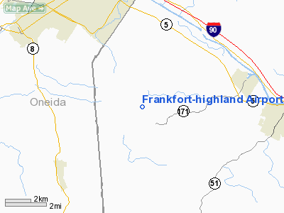
Frankfort-highland Airport |
Location & QuickFacts
| FAA Information Effective: | 2008-09-25 |
| Airport Identifier: | 6B4 |
| Airport Status: | Operational |
| Longitude/Latitude: | 075-10-13.5790W/43-01-15.2510N
-75.170439/43.020903 (Estimated) |
| Elevation: | 1325 ft / 403.86 m (Surveyed) |
| Land: | 45 acres |
| From nearest city: | 0 nautical miles of Utica/frankfort, NY |
| Location: | Herkimer County, NY |
| Magnetic Variation: | 13W (1985) |
Owner & Manager
| Ownership: | Privately owned |
| Owner: | Davand Aviation |
| Address: | Mcintyre Road
Frankfort, NY 13340 |
| Phone number: | 315-732-6449 |
| Manager: | Thomas Maugeri |
| Address: | 205 Hampton Rd.
Frankfort, NY 13340 |
| Phone number: | 315 732-9888 |
Airport Operations and Facilities
| Airport Use: | Open to public |
| Wind indicator: | Yes |
| Segmented Circle: | No |
| Control Tower: | No |
| Lighting Schedule: | RDO-CTL |
| Landing fee charge: | No |
| Sectional chart: | New York |
| Region: | AEA - Eastern |
| Boundary ARTCC: | ZBW - Boston |
| Tie-in FSS: | BUF - Buffalo |
| FSS on Airport: | No |
| FSS Toll Free: | 1-800-WX-BRIEF |
| NOTAMs Facility: | BUF (NOTAM-d service avaliable) |
| Federal Agreements: | N |
Airport Communications
| CTAF: | 122.800 |
| Unicom: | 122.800 |
Airport Services
| Fuel available: | 100LL |
| Bottled Oxygen: | NONE |
| Bulk Oxygen: | NONE |
Runway Information
Runway 13/31
| Dimension: | 2550 x 30 ft / 777.2 x 9.1 m |
| Surface: | ASPH, Fair Condition
5 FT WIDE HOLE ON RGT SIDE PVMT EDGE RY 13, 803 FT FM AER. |
| Weight Limit: | Single wheel: 12000 lbs. |
| Edge Lights: | Non-standard lighting system
NSTD LIRL; LGTS ARE 40 FT FM RY EDGE. |
| |
Runway 13 |
Runway 31 |
| Traffic Pattern: | Left | Left |
| Markings: | Nonstandard, Poor Condition
MARKINGS FADED. | Nonstandard, Poor Condition
MARKINGS FADED. |
| Displaced threshold: | 75.00 ft | 0.00 ft |
| Obstruction: | 50 ft trees, 200.0 ft from runway, 120 ft right of centerline
DISPLACEMENT 8:1 FROM DSPLCD THLD TO ROAD.
ROAD 50 FT FM PAVEMENT 125 FT FM DSPLCD THLD. | 45 ft brush, 800.0 ft from runway, 30 ft right of centerline, 13:1 slope to clear |
|
Radio Navigation Aids
| ID |
Type |
Name |
Ch |
Freq |
Var |
Dist |
| CJY | NDB | Clay | | 275.00 | 12W | 4.5 nm |
| BK | NDB | Plein | | 329.00 | 12W | 18.3 nm |
| JJH | NDB | Johnstown | | 523.00 | 14W | 36.9 nm |
| GSS | TACAN | Griffiss | 057X | | 12W | 16.5 nm |
| RKA | VOR/DME | Rockdale | 073X | 112.60 | 11W | 33.5 nm |
| UCA | VORTAC | Utica | 049X | 111.20 | 12W | 0.4 nm |
| GGT | VORTAC | Georgetown | 125X | 117.80 | 11W | 32.1 nm |
| SYR | VORTAC | Syracuse | 117X | 117.00 | 11W | 46.2 nm |
Remarks
- RY 31 HAS 120 FT DROPOFF 310 FT FM THLD ON BOTH SIDES.
- LIRL RY 13/31 NOT AVBL TO TSNT ACFT.
- MODEL PLANE CLUB OPERATES ON AIRPORT
- PRVDD OPNS AT ARPT ARE COORDINATED WITH UTICA ATCT.
Images and information placed above are from
http://www.airport-data.com/airport/6B4/
We thank them for the data!
| General Info
|
| Country |
United States
|
| State |
NEW YORK
|
| FAA ID |
6B4
|
| Latitude |
43-01-15.251N
|
| Longitude |
075-10-13.579W
|
| Elevation |
1325 feet
|
| Near City |
UTICA/FRANKFORT
|
We don't guarantee the information is fresh and accurate. The data may
be wrong or outdated.
For more up-to-date information please refer to other sources.
|
|


