|
|
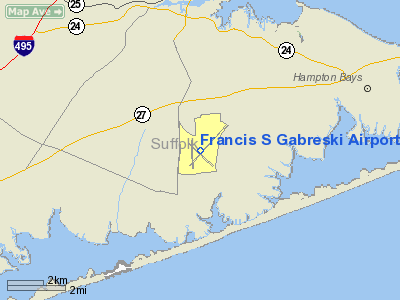
Francis S Gabreski Airport |
| Francis S. Gabreski Airport |
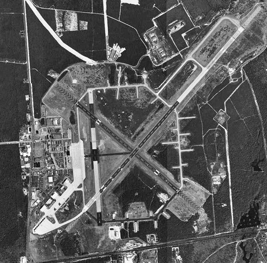 |
| USGS aerial image, 8 April 1994 |
| IATA: FOK – ICAO: KFOK – FAA LID: FOK |
| Summary |
| Airport type |
Public / Military (ANG) |
| Owner |
County of Suffolk |
| Serves |
Westhampton Beach, New York |
| Elevation AMSL |
67 ft / 20 m |
| Coordinates |
40°50′37″N 072°37′54″W / 40.84361°N 72.63167°W / 40.84361; -72.63167 |
| Website |
www.co.suffolk.ny.us/... |
| Runways |
| Direction |
Length |
Surface |
| ft |
m |
| 6/24 |
9,000 |
2,743 |
Asphalt/Concrete |
| 1/19 |
5,000 |
1,524 |
Asphalt/Concrete |
| 15/33 |
5,000 |
1,524 |
Asphalt |
| Statistics (2006) |
| Aircraft operations |
434,223 |
| Based aircraft |
107 |
| Source: Federal Aviation Administration |
Francis S. Gabreski Airport (IATA: FOK, ICAO: KFOK, FAA LID: FOK) is a county-owned, civil airport located 3 nautical miles (6 km) north of the central business district of Westhampton Beach, in Suffolk County, Long Island, New York, United States. It is approximately 80 miles (130 km) east of New York City.
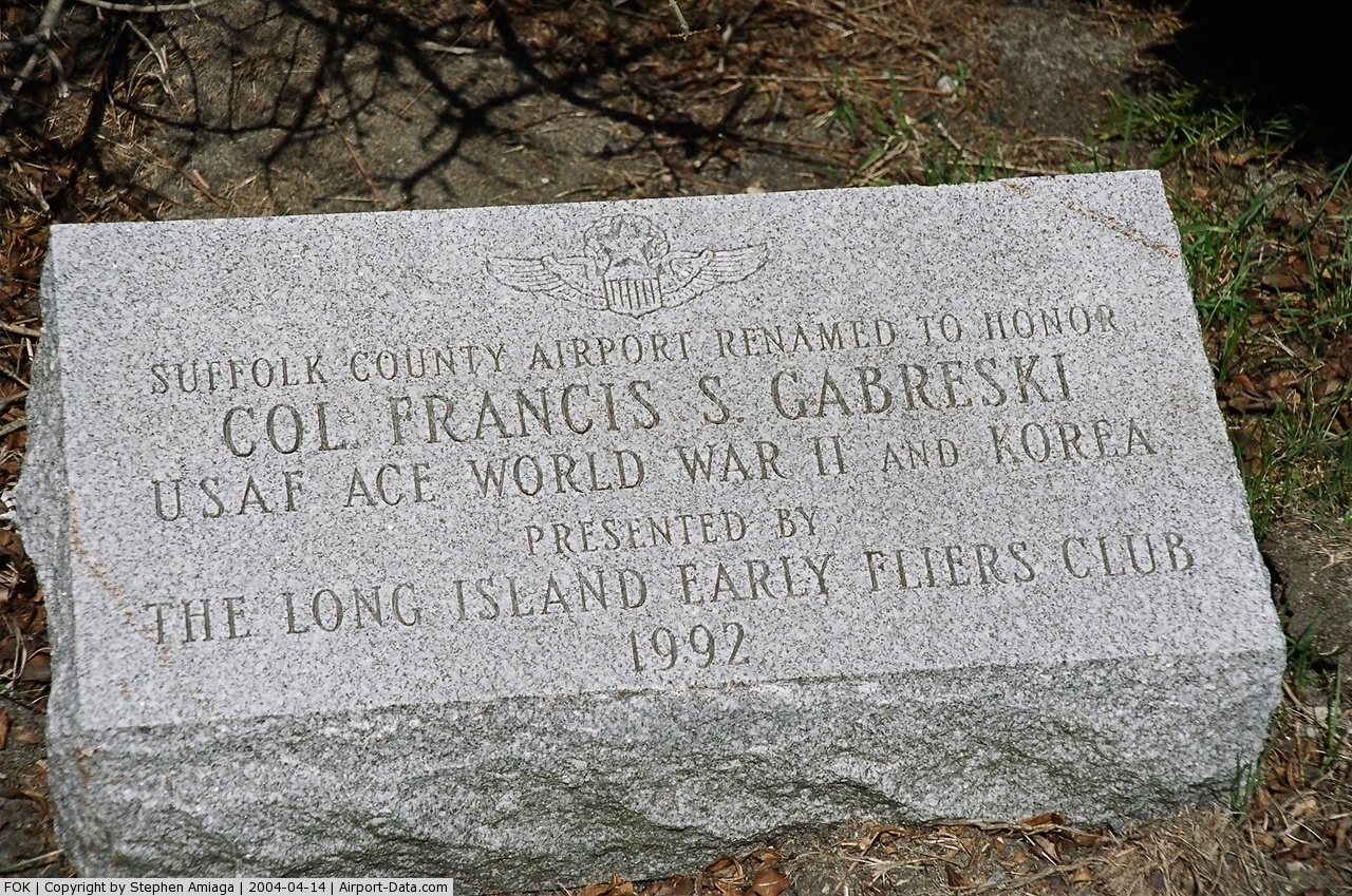
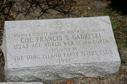
Known as Suffolk County Air Force Base until 1969, then Suffolk County Airport until 1991, when it was renamed in honor of Francis S. Gabreski, a flying ace in World War II who was the commander of the 52nd Fighter-Interceptor Wing at the base from 1964 through November 1967 when he retired.
The airport is both a general aviation facility utilized by corporate businesses, private aviation and air taxi services and an Air National Guard (ANG) base used by the 106th Rescue Wing (106 RQW), an Air Combat Command (ACC)-gained of the New York Air National Guard, which is also based here. HistoryMilitary operations were reintroduced in June 1970, when the 102nd Air Refueling Squadron (102 AREFS) of the 106th Air Refueling Group (106 ARG) of the New York Air National Guard relocated to Suffolk County with their KC-97 Stratotankers after the closing of Naval Air Station Floyd Bennett Field. In 1972, the unit's mission changed from air refueling to fighter-interceptor, with the new mission of controlling the skies along the northeast U.S. coast with F-102 Delta Dagger aircraft.
In 1975, the designation and mission changed again to "Aerospace Rescue and Recovery", later shortened to "Air Rescue" and then simply "Rescue". The current names of the 102nd Rescue Squadron (102 RQS) and 106th Rescue Wing (106 RQW) were assigned in 1995. Today, the 106 RQW provides search and rescue services using HC-130P Hercules aircraft and HH-60G Pave Hawk helicopters. The rescue wing was featured in the book and movie of The Perfect Storm which details the crash of one of the wing's HH-60G Pave Hawk rescue helicopters while conducting search and rescue operations from the airport during the 1991 Perfect Storm.
Air Force One was based at the airport in the summers of 1998 and 1999 during weeklong visits by President Bill Clinton and Hillary Clinton during extended stays at the Georgica Pond home of Steven Spielberg in East Hampton (village), New York.
Facilities and aircraft
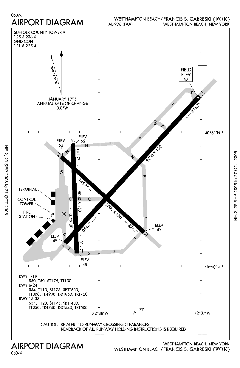
 | |
FAA diagram of Francis S. Gabreski Airport (FOK) |
Gabreski Airport covers an area of 1,451 acres (587 ha) which contains three paved runways. Runway 6/24 measures 9,000 x 150 ft (2,743 x 46 m), making it among New York's longest after JFK International Airport and Stewart International Airport. The airport has two additional runways (1/19 and 15/33), each measuring 5,000 x 150 ft (1,524 x 46 m).
For the 12-month period ending December 31, 2006, the airport had 434,223 aircraft operations, an average of 1,189 per day: 97% general aviation, 3% military and <1% air taxi. At that time there were 107 aircraft based at this airport: 79% single-engine, 6% multi-engine, 2% jet, 2% helicopter, 2% glider and 10% military.
Two fixed base operators provide aviation services to airport users: Long Island Jet Center and Malloy Air East.
The Suffolk County Police Aviation Section bases a Law Enforcement and MEDEVAC helicopter at the airport. The base is staffed from 7AM to 11PM by two Police Officer pilots as well as a Flight Paramedic employed by Stony Brook University Hospital. The airport is patrolled by the Suffolk County Sheriff's Office.
The above content comes from Wikipedia and is published under free licenses – click here to read more.
 |
(Click on the photo to enlarge) |
Location & QuickFacts
| FAA Information Effective: | 2008-09-25 |
| Airport Identifier: | FOK |
| Airport Status: | Operational |
| Longitude/Latitude: | 072-37-54.4410W/40-50-37.1570N
-72.631789/40.843655 (Estimated) |
| Elevation: | 67 ft / 20.42 m (Surveyed) |
| Land: | 1451 acres |
| From nearest city: | 3 nautical miles N of Westhampton Beach, NY |
| Location: | Suffolk County, NY |
| Magnetic Variation: | 13W (1980) |
Owner & Manager
| Ownership: | Publicly owned |
| Owner: | County Of Suffolk |
| Address: | County Center
Riverhead, NY 11901 |
| Phone number: | 631-852-1600 |
| Manager: | Anthony Ceglio |
| Address: | , Aviation Div. D.p.w.
Westhampton, NY 11978 |
| Phone number: | 631-852-8095 |
Airport Operations and Facilities
| Airport Use: | Open to public |
| Wind indicator: | Yes |
| Segmented Circle: | No |
| Control Tower: | Yes |
| Lighting Schedule: | DUSK-DAWN
WHEN ATCT CLSD ACTVT HIRL RY 06/24, MIRL RY 15/33, VASI RYS 33, PAPI RWY 06, 15 & 24, MALSR RY 24, REIL RYS 06, 15, & 33 - CTAF. |
| Beacon Color: | Clear-Green (lighted land airport) |
| Landing fee charge: | Yes |
| Sectional chart: | New York |
| Region: | AEA - Eastern |
| Traffic Pattern Alt: | 1100 ft |
| Boundary ARTCC: | ZBW - Boston |
| Responsible ARTCC: | ZNY - New York |
| Tie-in FSS: | ISP - New York |
| FSS on Airport: | No |
| FSS Toll Free: | 1-800-WX-BRIEF |
| NOTAMs Facility: | FOK (NOTAM-d service avaliable) |
| Federal Agreements: | NGPY3 |
Airport Communications
| CTAF: | 125.300 |
| Unicom: | 122.950 |
Airport Services
| Fuel available: | 100LLA |
| Airframe Repair: | MAJOR |
| Power Plant Repair: | MAJOR |
| Bottled Oxygen: | NONE |
| Bulk Oxygen: | NONE |
Runway Information
Runway 01/19
| Dimension: | 5000 x 150 ft / 1524.0 x 45.7 m
SOUTH END RY 900 FT & NORTH END RY 1000 FT ARE SAFETY AREAS.
RY 06/24 1000 FT SAFETY AREA EACH END.
RY 15/33 1000 FT SAFETY AREA EACH END. |
| Surface: | ASPH-CONC, Good Condition
4000 FT ASPH OVERLAY IN CENTER OF RY. |
| Pavement Class: | 17 /R/B/Y/T |
| Weight Limit: | Single wheel: 50000 lbs.
Dual wheel: 50000 lbs.
Dual tandem wheel: 100000 lbs. |
| |
Runway 01 |
Runway 19 |
| Longitude: | 072-38-13.1000W | 072-38-15.9470W |
| Latitude: | 40-50-05.6940N | 40-50-55.0460N |
| Elevation: | 48.00 ft | 65.00 ft |
| Alignment: | 127 | 127 |
| Traffic Pattern: | Left | Left |
| Markings: | Basic, Good Condition | Basic, Good Condition |
| Obstruction: | 27 ft trees, 1012.0 ft from runway, 328 ft right of centerline, 30:1 slope to clear | 27 ft trees, 1032.0 ft from runway, 319 ft right of centerline, 30:1 slope to clear |
|
Runway 06/24
| Dimension: | 9000 x 150 ft / 2743.2 x 45.7 m
SOUTH END RY 900 FT & NORTH END RY 1000 FT ARE SAFETY AREAS.
RY 06/24 1000 FT SAFETY AREA EACH END.
RY 15/33 1000 FT SAFETY AREA EACH END. |
| Surface: | ASPH-CONC, Good Condition
4000 FT ASPH OVERLAY IN CENTER OF RY. |
| Pavement Class: | 25 /R/C/X/T |
| Weight Limit: | Single wheel: 50000 lbs.
Dual wheel: 50000 lbs.
Dual tandem wheel: 100000 lbs. |
| Edge Lights: | High |
| |
Runway 06 |
Runway 24 |
| Longitude: | 072-38-20.4390W | 072-37-01.3150W |
| Latitude: | 40-50-10.4640N | 40-51-16.0190N |
| Elevation: | 49.00 ft | 67.00 ft |
| Alignment: | 43 | 127 |
| ILS Type: | | ILS
|
| Traffic Pattern: | Left | Right |
| Markings: | Precision instrument, Good Condition | Precision instrument, Good Condition |
| Crossing Height: | 66.00 ft | 85.00 ft |
| VASI: | 2-light PAPI on left side | 4-light PAPI on left side |
| Visual Glide Angle: | 3.00° | 3.00° |
| Approach lights: | | MALSR |
| Runway End Identifier: | Yes | |
| Obstruction: | 26 ft trees, 1117.0 ft from runway, 269 ft right of centerline, 35:1 slope to clear | 47 ft trees, 1733.0 ft from runway, 715 ft right of centerline, 32:1 slope to clear |
|
Runway 15/33
| Dimension: | 5000 x 150 ft / 1524.0 x 45.7 m
SOUTH END RY 900 FT & NORTH END RY 1000 FT ARE SAFETY AREAS.
RY 06/24 1000 FT SAFETY AREA EACH END.
RY 15/33 1000 FT SAFETY AREA EACH END. |
| Surface: | ASPH, Fair Condition
4000 FT ASPH OVERLAY IN CENTER OF RY. |
| Pavement Class: | 25 /R/C/X/T |
| Weight Limit: | Single wheel: 50000 lbs.
Dual wheel: 50000 lbs.
Dual tandem wheel: 100000 lbs. |
| Edge Lights: | Medium |
| |
Runway 15 |
Runway 33 |
| Longitude: | 072-38-22.7120W | 072-37-34.7410W |
| Latitude: | 40-50-49.8030N | 40-50-16.4170N |
| Elevation: | 64.00 ft | 49.00 ft |
| Alignment: | 127 | 127 |
| Traffic Pattern: | Left | Right |
| Markings: | Basic, Good Condition
15/33 MILITARY MAX EFFORT LNDG STRIP MARKINGS (3500 X 60) INCLUDED WITH BASIC RY MARKINGS. | Basic, Good Condition |
| Crossing Height: | 67.00 ft | 57.00 ft |
| VASI: | 2-light PAPI on left side | 4-box on left side |
| Visual Glide Angle: | 3.00° | 3.00° |
| Runway End Identifier: | Yes | Yes |
| Obstruction: | 18 ft trees, 1021.0 ft from runway, 190 ft left of centerline, 46:1 slope to clear | , 50:1 slope to clear |
|
Radio Navigation Aids
| ID |
Type |
Name |
Ch |
Freq |
Var |
Dist |
| OP | NDB | Old Field Point Light | | 316.00 | 13W | 23.5 nm |
| BBN | NDB | Babylon | | 275.00 | 14W | 35.8 nm |
| MMK | NDB | Meriden | | 238.00 | 14W | 41.1 nm |
| TBY | NDB | Waterbury | | 257.00 | 14W | 47.3 nm |
| HF | NDB | Lomis | | 244.00 | 15W | 47.6 nm |
| FOK | TACAN | Suffolk Co | 047X | | 13W | 0.4 nm |
| CCC | VOR/DME | Calverton | 119X | 117.20 | 13W | 9.2 nm |
| HVN | VOR/DME | New Haven | 035X | 109.80 | 13W | 27.7 nm |
| MAD | VOR/DME | Madison | 041X | 110.40 | 13W | 28.4 nm |
| BDR | VOR/DME | Bridgeport | 25X | 108.80 | 12W | 29.4 nm |
| DPK | VOR/DME | Deer Park | 124X | 117.70 | 12W | 30.7 nm |
| GON | VOR/DME | Groton | 45Y | 110.85 | 14W | 39.3 nm |
| HFD | VOR/DME | Hartford | 096X | 114.90 | 13W | 48.1 nm |
| HTO | VORTAC | Hampton | 083X | 113.60 | 13W | 15.0 nm |
| ISP | VOT | Long Island Mac Arthur | | 109.40 | | 21.3 nm |
| BDR | VOT | Bridgeport | | 109.25 | | 29.4 nm |
| GON | VOT | Groton | | 110.25 | | 39.1 nm |
Remarks
- OIL - O-148-156(MIL) SOAP.
- RSTD - NO 180‘ TURNS PERMS ON ASPHALT SECTION OF RWY 06-24.
- CAUTION: BIRDS AND DEER HAZ. PJE VCNTY OF ARPT. EXTV GLIDER ACTIVITY.
- CSTMS/AG/IMG: CSTMS CLNC SVC AVBL WITH PN C800-221-4265 OR C201-645-3737. MON-FRI MIN 24 HR PN; SUN AND HOL BEFORE 2200Z++ ON REGULAR BUS DAY PRECEDING SVC RQR DATE, MAX PAX 15.
- MISC - RWY 15-33 MIL MAX EFFORT LDG STRIP MRK 3500X60 ON RWY. CLASS D AIRSPACE EFF 1200-0400Z++; OT CLASS G.
- ANG: PPR DSN 456-7362/4, C631-723-7362/4. PPR FOR USE OF COPTER TRNS PAD. OPR 1230-2100Z++. CRASH FAC, LTD PRK AND TRAN SVC DUR NML DUTY HR LTD TO C-130 AND HH60 ACFT ONLY. NO SVC OT. RY CLSD TO ACFT AUW 100,000 LB EXC C130/EMERG UFN.
- US CUSTOMS CLNC SVC AVBL WITH PRIOR NOTICE 718-487-2691.
- VOLUNTARY NOISE ABATEMENT PROCEDURES IN EFFECT; CTC AMGR 631-852-8095.
- BEARING STRENGTH RWY 01-19: S50 T50 ST175 TT100.
- BEARING STENGTH RWY 06-24: S54 T110 ST175 SBTT600 TT300 TDT900 DDT850 TRT720.
- BEARING STENGTH RWY 15-33: S54 T120 ST175 SBTT430 TT250 TDT740 DDT540 TRT580.
- JASU: AVBL DUR ANG OPR HR. (A/M32A-86) 2(MA-1A).
- FUEL: AVBL DUR ANG OPR HR. J8(MIL) (NC-100LL, A).
- FLUID - SP DE-ICE LOX.
- EXISTED PRIOR TO 1959. CHANGE TO CIVIL OPN.
Images and information placed above are from
http://www.airport-data.com/airport/FOK/
We thank them for the data!
| General Info
|
| Country |
United States
|
| State |
NEW YORK
|
| FAA ID |
FOK
|
| Latitude |
40-50-37.157N
|
| Longitude |
072-37-54.441W
|
| Elevation |
67 feet
|
| Near City |
WESTHAMPTON BEACH
|
We don't guarantee the information is fresh and accurate. The data may
be wrong or outdated.
For more up-to-date information please refer to other sources.
|
|