 |
|
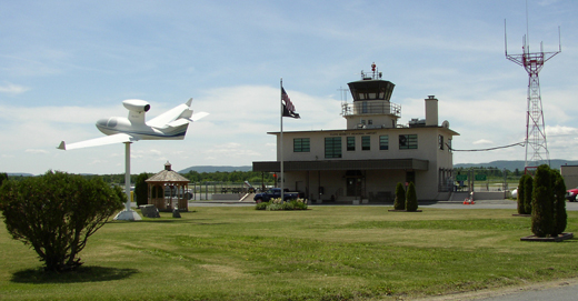
Floyd Bennett Memorial Airport |
| Floyd Bennett Memorial Airport |
 |
| IATA: GFL – ICAO: KGFL |
| Summary |
| Airport type |
Public |
| Operator |
Warren County |
| Location |
Queensbury, New York |
| Elevation AMSL |
328 ft / 100 m |
| Coordinates |
43°20′28.4″N 73°36′37.1″W / 43.341222°N 73.610306°W / 43.341222; -73.610306Coordinates: 43°20′28.4″N 73°36′37.1″W / 43.341222°N 73.610306°W / 43.341222; -73.610306 |
| Runways |
| Direction |
Length |
Surface |
| ft |
m |
| 1/19 |
5,000 |
1,524 |
Asphalt |
| 12/30 |
4,000 |
1,219 |
Asphalt |
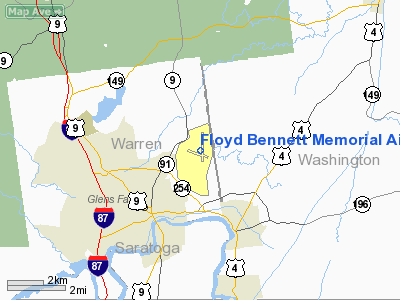
Floyd Bennett Memorial Airport (IATA: GFL, ICAO: KGFL), formerly known as Warren County Airport, is a public airport located in the town of Queensbury three miles (5 km) northeast of the city of Glens Falls in Warren County, New York, USA. It is named in honor of Floyd Bennett, the pilot for the first flight ever over the North Pole.
The annual Adirondack Balloon Festival is held at this airport. History
From 1918 to 1946, the county's only airport, Floyd Bennett Field, was located on what are now the grounds of Queensbury High School. In 1941, ground was broken a few miles east at what is now the current site of the airport. The airport has been served commercially by Colonial Airlines (1940s), Eastern Air Lines (1950s), Mohawk Airlines(1950s - 1970s), Allegheny Airlines (1970s), and Air North (1960s-1980s).
Facilities
Floyd Bennett Memorial Airport covers 500 acres (202 ha) and has two runways:
- Runway 1/19: 5,000 x 150 ft (1,524 x 46 m), Surface: Asphalt
- Runway 12/30: 4,000 x 100 ft (1,219 x 30 m), Surface: Asphalt
The north-facing runway 1 is equipped with an instrument landing system and a medium intensity approach lighting system with runway alignment lights. GPS-based instrument approaches are available to all four runway ends. A VORTAC is located at the field and during the 1990s and earlier was used as the basis for IFR approaches to the main runway.
Incidents and Accidents
On November 19, 1969, Mohawk Airlines Flight 411 crashed into Pilot Knob Mountain while attempting to land at the conclusion of a flight from Albany. All 14 passengers and crew were killed in the accident.
The above content comes from Wikipedia and is published under free licenses – click here to read more.
Location & QuickFacts
| FAA Information Effective: | 2008-09-25 |
| Airport Identifier: | GFL |
| Airport Status: | Operational |
| Longitude/Latitude: | 073-36-37.1000W/43-20-28.4000N
-73.610306/43.341222 (Estimated) |
| Elevation: | 328 ft / 99.97 m (Surveyed) |
| Land: | 550 acres |
| From nearest city: | 3 nautical miles NE of Glens Falls, NY |
| Location: | Warren County, NY |
| Magnetic Variation: | 14W (1980) |
Owner & Manager
| Ownership: | Publicly owned |
| Owner: | Warren County |
| Address: | 4028 Main St
Warrensburg, NY 12885-0010 |
| Phone number: | 518-761-6556 |
| Manager: | Marshall Stevens |
| Address: | 443 Queensbury Ave, Rm 201
Queensbury, NY 12804 |
| Phone number: | 518-792-5995 |
Airport Operations and Facilities
| Airport Use: | Open to public |
| Wind indicator: | Yes |
| Segmented Circle: | Yes |
| Control Tower: | No |
| Lighting Schedule: | DUSK-DAWN
ACTVT HIRL RY 01/19; MIRL RY 12/30; MALSR RY 01; VASI RYS 01 & 19; TWY LGTS - CTAF. |
| Beacon Color: | Clear-Green (lighted land airport) |
| Landing fee charge: | No |
| Sectional chart: | New York |
| Region: | AEA - Eastern |
| Traffic Pattern Alt: | 800 ft |
| Boundary ARTCC: | ZBW - Boston |
| Tie-in FSS: | BTV - Burlington |
| FSS on Airport: | No |
| FSS Toll Free: | 1-800-WX-BRIEF |
| NOTAMs Facility: | GFL (NOTAM-d service avaliable) |
| Certification type/date: | IV A U 06/197
PPR 24 HRS FOR ACR OPNS WITH MORE THAN 30 PSGR SEATS CALL AMGR 518-792-5995 OR IF NO RESPONSE CTC 518-743-2500 (EXT-1). |
| Federal Agreements: | NGY3 |
Airport Communications
| CTAF: | 123.000 |
| Unicom: | 123.000 |
Airport Services
| Fuel available: | 100LLA
FUELING AVBL AFTER HRS BY PRE-ARRANGEMENT; CALL 518-792-5995. REFUELING FEE AFTER 2000. |
| Airframe Repair: | MAJOR |
| Power Plant Repair: | MAJOR |
| Bottled Oxygen: | NONE |
| Bulk Oxygen: | NONE |
Runway Information
Runway 01/19
| Dimension: | 5000 x 150 ft / 1524.0 x 45.7 m |
| Surface: | ASPH, Good Condition
RW 12/30 - LONGITUDINAL CRACKING
LONGITUDINAL CRACKING. |
| Surface Treatment: | Saw-cut or plastic Grooved |
| Weight Limit: | Single wheel: 80000 lbs.
Dual wheel: 110000 lbs.
Dual tandem wheel: 180000 lbs. |
| Edge Lights: | High |
| |
Runway 01 |
Runway 19 |
| Longitude: | 073-36-31.2490W | 073-36-33.1028W |
| Latitude: | 43-20-08.4142N | 43-20-57.7812N |
| Elevation: | 322.00 ft | 326.00 ft |
| Alignment: | 127 | 127 |
| ILS Type: | ILS
| |
| Traffic Pattern: | Left | Left |
| Markings: | Precision instrument, Good Condition | Non-precision instrument, Good Condition |
| Crossing Height: | 52.00 ft | 48.00 ft |
| VASI: | 4-box on left side
VASI RY 01 OTS INDEFLY. | 4-box on left side
VASI RY 19 OTS INDEFLY. |
| Visual Glide Angle: | 3.00° | 3.00° |
| Approach lights: | MALSR | |
| Obstruction: | 120 ft trees, 2640.0 ft from runway, 840 ft right of centerline, 20:1 slope to clear | 103 ft trees, 1230.0 ft from runway, 580 ft right of centerline, 10:1 slope to clear |
|
Runway 12/30
| Dimension: | 4000 x 100 ft / 1219.2 x 30.5 m |
| Surface: | ASPH, Fair Condition
RW 12/30 - LONGITUDINAL CRACKING
LONGITUDINAL CRACKING. |
| Weight Limit: | Single wheel: 39000 lbs.
Dual wheel: 53000 lbs.
Dual tandem wheel: 76000 lbs. |
| Edge Lights: | Medium |
| |
Runway 12 |
Runway 30 |
| Longitude: | 073-37-08.6125W | 073-36-17.8995W |
| Latitude: | 43-20-29.3235N | 43-20-15.5288N |
| Elevation: | 328.00 ft | 324.00 ft |
| Alignment: | 110 | 127 |
| Traffic Pattern: | Left | Left |
| Markings: | Non-precision instrument, Good Condition | Non-precision instrument, Good Condition |
| Obstruction: | 67 ft tree, 1270.0 ft from runway, 120 ft left of centerline, 15:1 slope to clear | 69 ft tree, 1110.0 ft from runway, 320 ft left of centerline, 13:1 slope to clear
+4 FT GND 190 FT FM AER 230 FT R. |
|
Radio Navigation Aids
| ID |
Type |
Name |
Ch |
Freq |
Var |
Dist |
| R | FAN MARKER | Chitt | | | 14W | 32.9 nm |
| HEU | NDB | Hunter | | 356.00 | 14W | 32.6 nm |
| DYO | NDB | Smuto | | 221.00 | 15W | 35.9 nm |
| JJH | NDB | Johnstown | | 523.00 | 14W | 37.7 nm |
| VWD | NDB | Mount Snow | | 224.00 | 15W | 41.1 nm |
| SXD | NDB | Springfield | | 265.00 | 15W | 45.0 nm |
| CAM | VOR/DME | Cambridge | 097X | 115.00 | 14W | 23.9 nm |
| RUT | VOR/DME | Rutland | 47X | 111.00 | 15W | 30.9 nm |
| ALB | VORTAC | Albany | 100X | 115.30 | 13W | 36.7 nm |
| ALB | VOT | Albany County | | 108.20 | | 37.2 nm |
Remarks
- RYS 12 & 19 APCHS OBSCURED FROM ONE ANOTHER DUE TO HIGH GROUND.
- FOUR OBSTN LGT POLES 1-1/2 MI TO 1-3/4 MI N OF RY 19.
- BIRDS/DEER ON & INVOF ARPT.
- RY 01 DESIGNATED CALM WIND RY.
- GRASS CUTTING EQUIPMENT OPS ADJACENT TO ALL OPERATIONAL SURFACES DALGT HRS MAY THRU OCT.
- ULTRALGT ACTIVITY ON & INVOF ARPT.
- ULTRALGT ACFT USE 500 FT AGL LEFT TFC FOR ALL RYS.
- DURING PERIODS OF SNOW REMOVAL OPNS NOV 1-APR 1 ACFT MUST CTC ARPT ON FREQ 123.0 10 MINS PRIOR TO LDG.
Images and information placed above are from
http://www.airport-data.com/airport/GFL/
We thank them for the data!
| General Info
|
| Country |
United States
|
| State |
NEW YORK
|
| FAA ID |
GFL
|
| Latitude |
43-20-28.400N
|
| Longitude |
073-36-37.100W
|
| Elevation |
328 feet
|
| Near City |
GLENS FALLS
|
We don't guarantee the information is fresh and accurate. The data may
be wrong or outdated.
For more up-to-date information please refer to other sources.
|
|


