 |
|
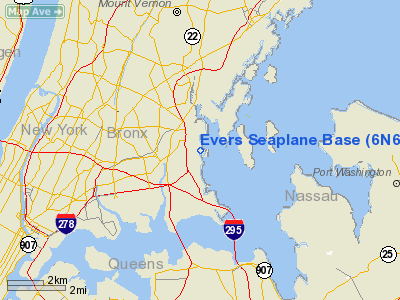
Evers Seaplane Base Airport |
Location & QuickFacts
| FAA Information Effective: | 2008-09-25 |
| Airport Identifier: | 6N6 |
| Airport Status: | Operational |
| Longitude/Latitude: | 073-48-58.4810W/40-50-45.3610N
-73.816245/40.845934 (Estimated) |
| Elevation: | 0 ft / 0.00 m (Estimated) |
| Land: | 0 acres |
| From nearest city: | 12 nautical miles NE of New York, NY |
| Location: | Bronx County, NY |
| Magnetic Variation: | 13W (1985) |
Owner & Manager
| Ownership: | Privately owned |
| Owner: | Charles Evers |
| Address: | 1470 Outlook Avenue
Bronx, NY 10465 |
| Phone number: | 718-863-9111 |
| Manager: | Charles Evers |
| Address: | 1470 Outlook Ave
New York, NY 10465 |
| Phone number: | 718-863-9111 |
Airport Operations and Facilities
| Airport Use: | Open to public |
| Wind indicator: | Yes |
| Segmented Circle: | No |
| Control Tower: | No |
| Landing fee charge: | No |
| Sectional chart: | New York |
| Region: | AEA - Eastern |
| Boundary ARTCC: | ZNY - New York |
| Tie-in FSS: | ISP - New York |
| FSS on Airport: | No |
| FSS Toll Free: | 1-800-WX-BRIEF |
| NOTAMs Facility: | ISP (NOTAM-d service avaliable) |
Airport Communications
Airport Services
| Fuel available: | MOGAS |
| Bottled Oxygen: | NONE |
| Bulk Oxygen: | NONE |
Runway Information
Runway ALL/WAY
| Dimension: | 5000 x 400 ft / 1524.0 x 121.9 m |
| Surface: | WATER, |
| |
Runway ALL |
Runway WAY |
| Traffic Pattern: | Left | Left |
|
Radio Navigation Aids
| ID |
Type |
Name |
Ch |
Freq |
Var |
Dist |
| EWR | FAN MARKER | Maryann | | | 11W | 18.9 nm |
| SKU | FAN MARKER | Stanwyck | | | 12W | 42.3 nm |
| PNJ | NDB | Paterson | | 347.00 | 12W | 16.4 nm |
| OGY | NDB | Bridge | | 414.00 | 12W | 17.0 nm |
| BBN | NDB | Babylon | | 275.00 | 14W | 22.3 nm |
| CAT | NDB | Chatham | | 254.00 | 11W | 28.6 nm |
| OP | NDB | Old Field Point Light | | 316.00 | 13W | 32.7 nm |
| SKU | NDB | Stanwyck | | 261.00 | 12W | 42.3 nm |
| SW | NDB | Neely | | 335.00 | 14W | 42.7 nm |
| PO | NDB | Meier | | 403.00 | 12W | 44.3 nm |
| LGA | VOR/DME | La Guardia | 078X | 113.10 | 12W | 4.5 nm |
| TEB | VOR/DME | Teterboro | 021X | 108.40 | 11W | 11.2 nm |
| JFK | VOR/DME | Kennedy | 106X | 115.90 | 12W | 13.0 nm |
| CRI | VOR/DME | Canarsie | 070X | 112.30 | 11W | 14.5 nm |
| DPK | VOR/DME | Deer Park | 124X | 117.70 | 12W | 23.5 nm |
| CMK | VOR/DME | Carmel | 113X | 116.60 | 12W | 28.2 nm |
| COL | VOR/DME | Colts Neck | 101X | 115.40 | 11W | 35.7 nm |
| BDR | VOR/DME | Bridgeport | 25X | 108.80 | 12W | 36.6 nm |
| SBJ | VOR/DME | Solberg | 076X | 112.90 | 10W | 45.0 nm |
| BWZ | VOR/DME | Broadway | 089X | 114.20 | 11W | 45.8 nm |
| CCC | VOR/DME | Calverton | 119X | 117.20 | 13W | 46.5 nm |
| STW | VOR/DME | Stillwater | 033X | 109.60 | 11W | 48.7 nm |
| HUO | VOR/DME | Huguenot | 108X | 116.10 | 11W | 48.8 nm |
| HVN | VOR/DME | New Haven | 035X | 109.80 | 13W | 49.1 nm |
| IGN | VOR/DME | Kingston | 123X | 117.60 | 12W | 49.3 nm |
| SAX | VORTAC | Sparta | 104X | 115.70 | 11W | 35.4 nm |
| RBV | VORTAC | Robbinsville | 085X | 113.80 | 10W | 49.6 nm |
| JFK | VOT | Kennedy | | 115.10 | | 12.8 nm |
| ISP | VOT | Long Island Mac Arthur | | 109.40 | | 33.0 nm |
| BDR | VOT | Bridgeport | | 109.25 | | 36.6 nm |
Remarks
- LEFT TFC PAT IS W, SW, S, SE & RIGHT TFC PAT IS E, NE, N & NW WITH ALL TURNS OVER WATER. MIN ALT 300' BASE TO FINAL TURN.
- UNLIGHTED HELIPAD ON BARGE APPROXIMATELY 350' NE OF LANDING DOCK AND RAMP.
- DALGT OPNS ONLY.
- VFR USE ONLY
Images and information placed above are from
http://www.airport-data.com/airport/6N6/
We thank them for the data!
| General Info
|
| Country |
United States
|
| State |
NEW YORK
|
| FAA ID |
6N6
|
| Latitude |
40-50-45.361N
|
| Longitude |
073-48-58.481W
|
| Elevation |
0 feet
|
| Near City |
NEW YORK
|
We don't guarantee the information is fresh and accurate. The data may
be wrong or outdated.
For more up-to-date information please refer to other sources.
|
|


