 |
|
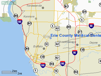
Erie County Medical Center Heliport |
Location & QuickFacts
| FAA Information Effective: | 2008-09-25 |
| Airport Identifier: | 6NK5 |
| Airport Status: | Operational |
| Longitude/Latitude: | 078-49-58.0000W/42-55-36.0000N
-78.832778/42.926667 (Estimated) |
| Elevation: | 728 ft / 221.89 m (Estimated) |
| Land: | 0 acres |
| From nearest city: | 1 nautical miles N of Buffalo, NY |
| Location: | Erie County, NY |
| Magnetic Variation: | 10W (1995) |
Owner & Manager
| Ownership: | Privately owned |
| Owner: | Erie Co Medical Center |
| Address: | 762 Grider St
Buffalo, NY 14215 |
| Phone number: | 716-898-3588 |
| Manager: | Chris Zak |
| Address: | 762 Grider St
Buffalo, NY 14215 |
| Phone number: | 716-88-3588 |
Airport Operations and Facilities
| Airport Use: | Private |
| Wind indicator: | Yes |
| Segmented Circle: | No |
| Control Tower: | No |
| Lighting Schedule: | PHONE REQ
FOR PERIMETER LGTS CALL 716-898-3588. |
| Sectional chart: | Detroit |
| Region: | AEA - Eastern |
| Boundary ARTCC: | ZOB - Cleveland |
| Tie-in FSS: | BUF - Buffalo |
| FSS Toll Free: | 1-800-WX-BRIEF |
Runway Information
Helipad H1
| Dimension: | 45 x 45 ft / 13.7 x 13.7 m |
| Surface: | MATS, |
| |
Runway H1 |
Runway |
| Traffic Pattern: | Left | Left |
|
Radio Navigation Aids
| ID |
Type |
Name |
Ch |
Freq |
Var |
Dist |
| SN | NDB | St Catherines | | 408.00 | 01E | 22.8 nm |
| LYS | NDB | Olean | | 360.00 | 09W | 44.5 nm |
| AVN | NDB | Avon | | 344.00 | 09W | 47.0 nm |
| TZ | NDB | Gibraltar Point | | 257.00 | 10W | 47.8 nm |
| IAG | TACAN | Niagara Falls | 047X | | 10W | 12.5 nm |
| BUF | VOR/DME | Buffalo | 111X | 116.40 | 08W | 8.2 nm |
| JHW | VOR/DME | Jamestown | 094X | 114.70 | 07W | 46.2 nm |
| GEE | VOR/DME | Geneseo | 019X | 108.20 | 09W | 48.8 nm |
| DKK | VORTAC | Dunkirk | 109X | 116.20 | 07W | 32.7 nm |
| BUF | VOT | Buffalo | | 109.00 | | 4.4 nm |
Remarks
- PRVDD CLEAR 8:1 INGRESS/EGRESS, APPROPRIATE INGRESS/EGRESS MKGS, VEHICULAR TFC AROUND SITE CONTROLLED, & VFR ONLY.
Images and information placed above are from
http://www.airport-data.com/airport/6NK5/
We thank them for the data!
| General Info
|
| Country |
United States
|
| State |
NEW YORK
|
| FAA ID |
6NK5
|
| Latitude |
42-55-36.000N
|
| Longitude |
078-49-58.000W
|
| Elevation |
728 feet
|
| Near City |
BUFFALO
|
We don't guarantee the information is fresh and accurate. The data may
be wrong or outdated.
For more up-to-date information please refer to other sources.
|
|


