 |
|
Elmira/corning Rgnl Airport |
| Elmira/Corning Regional Airport |
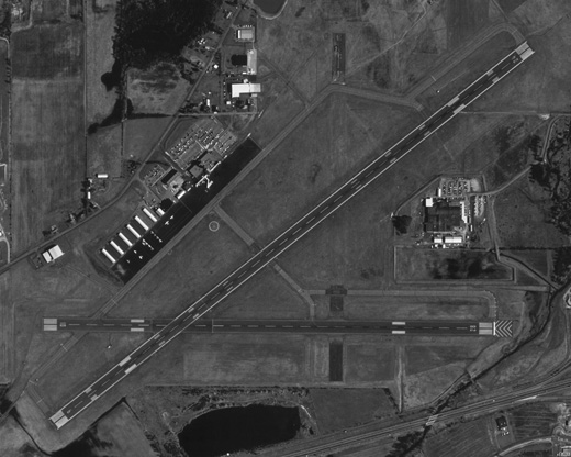 |
| USGS aerial image - 22 April 1994 |
| IATA: ELM – ICAO: KELM – FAA LID: ELM |
| Summary |
| Airport type |
Public |
| Owner |
County of Chemung |
| Serves |
Elmira / Corning, New York |
| Location |
Big Flats / Horseheads |
| Elevation AMSL |
954 ft / 291 m |
| Coordinates |
42°09′36″N 076°53′30″W / 42.16°N 76.89167°W / 42.16; -76.89167 |
| Website |
www.ecairport.com |
| Runways |
| Direction |
Length |
Surface |
| ft |
m |
| 6/24 |
7,599 |
2,316 |
Asphalt |
| 10/28 |
5,404 |
1,647 |
Asphalt |
| 5/23 |
2,017 |
615 |
Turf |
| Statistics (2007) |
| Aircraft operations |
41,865 |
| Based aircraft |
57 |
| Source: Federal Aviation Administration |
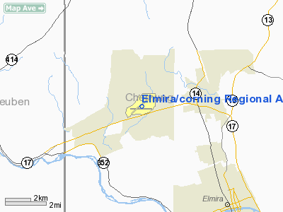
FAA diagram of Elmira/Corning Regional Airport (ELM) Elmira/Corning Regional Airport (IATA: ELM, ICAO: KELM, FAA LID: ELM) is a county-owned, public-use airport in Chemung County, New York, United States. The airport is six nautical miles (11 km) northwest of the central business district of the city of Elmira and seven nautical miles (13 km) east of the city of Corning. It is located in the town of Big Flats, but its mailing address is in the adjacent town of Horseheads, New York. The airport was formerly known as Elmira Regional Airport.
The airport serves the Southern Tier of New York, primarily Chemung and Steuben counties. It has scheduled air service along with general aviation and glider activities. It is north of the Southern Tier Expressway (New York State Route 17). Other similar airports within the same service area include Greater Binghamton Airport and Ithaca Tompkins Regional Airport. Greater Rochester International Airport and Syracuse International Airport are the closest two airports with low cost carrier service. Facilities and aircraft
Elmira/Corning Regional Airport covers an area of 1,000 acres (405 ha) at an elevation of 954 feet (291 m) above mean sea level. It has three runways: 6/24 is 7,599 by 150 feet (2,316 x 46 m) with an asphalt surface; 10/28 is 5,404 by 150 feet (1,647 x 46 m) with an asphalt surface; 5/23 is 2,017 by 150 feet (615 x 46 m) with a turf.
For the 12-month period ending December 31, 2007, the airport had 41,865 aircraft operations, an average of 114 per day: 75% general aviation, 25% air taxi, <1% scheduled commercial and <1% military. At that time there were 57 aircraft based at this airport: 63% single-engine, 11% multi-engine, 14% jet, 9% glider and 4% helicopter.
An aviation museum known as Wings of Eagles is located at the airport. Airport services include free wireless Internet access, automatic teller machines (ATM), conference rooms, and the DC2 Restaurant. The Helicopter manufacturer Schweizer Aircraft is also located at the airport.
Airlines and destinations
| Airlines |
Destinations |
| Allegiant Air |
Fort Lauderdale [begins November 19], Orlando-Sanford |
| Delta Connection operated by Pinnacle Airlines |
Detroit |
| US Airways Express operated by Air Wisconsin |
Philadelphia |
| US Airways Express operated by Piedmont Airlines |
Philadelphia |
IncidentsOn June 23, 1967, Mohawk Airlines Flight 40, operated on a BAC-111 regional jet, crashed in Blossburg, Pennsylvania, shortly after taking off from Elmira-Corning, killing all 34 persons (30 passengers and 4 crew) on board.
The above content comes from Wikipedia and is published under free licenses – click here to read more.
Location & QuickFacts
| FAA Information Effective: | 2008-09-25 |
| Airport Identifier: | ELM |
| Airport Status: | Operational |
| Longitude/Latitude: | 076-53-29.8000W/42-09-35.6000N
-76.891611/42.159889 (Estimated) |
| Elevation: | 954 ft / 290.78 m (Surveyed) |
| Land: | 1000 acres |
| From nearest city: | 6 nautical miles NW of Elmira/corning, NY |
| Location: | Chemung County, NY |
| Magnetic Variation: | 12W (2000) |
Owner & Manager
| Ownership: | Publicly owned |
| Owner: | County Of Chemung |
| Address: | 276 Sing Sing Rd., Suite 1
Horseheads, NY 14845 |
| Phone number: | 607-739-5621
OR 607-739-5622. |
| Manager: | Ann B Crook |
| Address: | 276 Sing Sing Rd.,suite 1
Horseheads, NY 14845 |
| Phone number: | 607-739-5621 |
Airport Operations and Facilities
| Airport Use: | Open to public |
| Wind indicator: | Yes |
| Segmented Circle: | No |
| Control Tower: | Yes |
| Lighting Schedule: | DUSK-DAWN
WHEN ATCT CLSD ACTVT HIRL RY 06/24, MALSR RYS 06 & 24, TWY LGTS TWYS A & C NORTH OF RY 06/24 - CTAF; FOR MIRL RY 10/28 & ALL OTHER TWY LGTS CALL 607-426-5621. |
| Beacon Color: | Clear-Green (lighted land airport) |
| Landing fee charge: | Yes
LNDG FEE FOR ALL NON BASED ACFT. |
| Sectional chart: | New York |
| Region: | AEA - Eastern |
| Traffic Pattern Alt: | 1145 ft |
| Boundary ARTCC: | ZNY - New York |
| Tie-in FSS: | BUF - Buffalo |
| FSS Toll Free: | 1-800-WX-BRIEF |
| NOTAMs Facility: | ELM (NOTAM-d service avaliable) |
| Certification type/date: | I B S 05/1973 |
| Federal Agreements: | NGY3 |
Airport Communications
| CTAF: | 121.100 |
| Unicom: | 122.950 |
Airport Services
| Fuel available: | 100LLA |
| Airframe Repair: | MAJOR |
| Power Plant Repair: | MAJOR |
| Bottled Oxygen: | LOW |
| Bulk Oxygen: | NONE |
Runway Information
Runway 05/23
| Dimension: | 2017 x 150 ft / 614.8 x 45.7 m |
| Surface: | TURF, Good Condition |
| |
Runway 05 |
Runway 23 |
| Longitude: | 076-53-25.2966W | 076-53-04.6846W |
| Latitude: | 42-09-37.2890N | 42-09-50.0031N |
| Elevation: | 944.00 ft | 944.00 ft |
| Alignment: | 50 | 127 |
| Traffic Pattern: | Left | Left |
| Decleard distances: | Take off run available 2017.00 ft
Take off distance available 2017.00 ft
Actual stop distance available 2017.00 ft
Landing distance available 2017.00 ft
| Take off run available 2017.00 ft
Take off distance available 2017.00 ft
Actual stop distance available 2017.00 ft
Landing distance available 2017.00 ft
|
|
Runway 06/24
| Dimension: | 7599 x 150 ft / 2316.2 x 45.7 m |
| Surface: | ASPH, Good Condition |
| Surface Treatment: | Saw-cut or plastic Grooved |
| Weight Limit: | Single wheel: 80000 lbs.
Dual wheel: 121000 lbs.
Dual tandem wheel: 200000 lbs. |
| Edge Lights: | High |
| |
Runway 06 |
Runway 24 |
| Longitude: | 076-54-12.0610W | 076-52-54.3269W |
| Latitude: | 42-09-13.0030N | 42-10-00.8587N |
| Elevation: | 943.00 ft | 954.00 ft |
| Alignment: | 50 | 127 |
| ILS Type: | ILS
| ILS
|
| Traffic Pattern: | Left | Left |
| Markings: | Precision instrument, Good Condition | Precision instrument, Good Condition |
| Crossing Height: | 51.00 ft | 52.00 ft |
| Displaced threshold: | 600.00 ft | 0.00 ft |
| VASI: | 4-box on left side | 4-box on left side |
| Visual Glide Angle: | 3.00° | 3.00° |
| RVR Equipment: | | touchdown |
| Approach lights: | MALSR | MALSR |
| Obstruction: | 790 ft tree, 27250.0 ft from runway, 1800 ft right of centerline, 34:1 slope to clear | 387 ft tree, 12810.0 ft from runway, 2160 ft right of centerline, 32:1 slope to clear |
| Decleard distances: | Take off run available 7599.00 ft
Take off distance available 7599.00 ft
Actual stop distance available 7599.00 ft
Landing distance available 6999.00 ft
| Take off run available 7599.00 ft
Take off distance available 7599.00 ft
Actual stop distance available 7599.00 ft
Landing distance available 7599.00 ft
|
|
Runway 10/28
| Dimension: | 5404 x 150 ft / 1647.1 x 45.7 m |
| Surface: | ASPH, Good Condition |
| Surface Treatment: | Saw-cut or plastic Grooved |
| Weight Limit: | Single wheel: 57000 lbs.
Dual wheel: 90000 lbs.
Dual tandem wheel: 150000 lbs. |
| Edge Lights: | Medium |
| |
Runway 10 |
Runway 28 |
| Longitude: | 076-54-10.6180W | 076-52-58.8845W |
| Latitude: | 42-09-28.0657N | 42-09-28.7337N |
| Elevation: | 934.00 ft | 944.00 ft |
| Alignment: | 89 | 127 |
| Traffic Pattern: | Left | Left |
| Markings: | Non-precision instrument, Good Condition | Non-precision instrument, Good Condition |
| Crossing Height: | 0.00 ft | 40.00 ft |
| Displaced threshold: | 0.00 ft | 400.00 ft |
| VASI: | | 4-light PAPI on left side |
| Visual Glide Angle: | 0.00° | 3.00° |
| Decleard distances: | Take off run available 5404.00 ft
Take off distance available 5404.00 ft
Actual stop distance available 5004.00 ft
Landing distance available 5004.00 ft
| Take off run available 5404.00 ft
Take off distance available 5404.00 ft
Actual stop distance available 5404.00 ft
Landing distance available 5004.00 ft
|
|
Radio Navigation Aids
| ID |
Type |
Name |
Ch |
Freq |
Var |
Dist |
| ALP | NDB | Alpine | | 245.00 | 12W | 7.4 nm |
| PYA | NDB | Penn Yan | | 260.00 | 12W | 30.0 nm |
| EL | NDB | Halos | | 269.00 | 09W | 45.7 nm |
| ULW | VOR/DME | Elmira | 033Y | 109.65 | 12W | 7.1 nm |
| ITH | VOR/DME | Ithaca | 055X | 111.80 | 10W | 27.8 nm |
| SFK | VOR/DME | Stonyfork | 023X | 108.60 | 08W | 36.6 nm |
| FQM | VOR/DME | Williamsport | 091X | 114.40 | 09W | 49.6 nm |
| CFB | VORTAC | Binghamton | 059X | 112.20 | 10W | 33.6 nm |
| ELZ | VORTAC | Wellsville | 051X | 111.40 | 09W | 49.6 nm |
Remarks
- ACFT WITH WINGSPANS GREATER THAN 93 FEET SHOULD USE EXTREME CARE WHEN TAXIING ON TWY A ADJ TO RAMPS.
- EXTSV GLIDER ACTIVITY.
- BIRDS & DEER ON & INVOF ARPT.
- RY 05/23 (SOUTHEAST OF RY 06/24) UNMARKED SEASONAL USE TURF RY CLSD 1 DEC THROUGH 30 APR.
- FOR LAND SIDE ACCESS FM APRON WHEN FBO CLSD CTC ELM ARPT ATTENDANT AT 607-426-5621.
- WINTER DE-ICING ON GLYCOL RAMP ONLY.
- BLIMP ACTIVITY REQUIRES PPR, CTC ARPT MANAGEMENT AT 607-426-5622.
- WHEN ELM ATCT CLSD, CLNC DELIVERY/CANCELLATIONS AVBL THRU RCO 122.2/122.4 OR CALL BUF AFSS 1-800-WX-BRIEF.
- EXISTED PRIOR TO 1959.
Images and information placed above are from
http://www.airport-data.com/airport/ELM/
We thank them for the data!
| General Info
|
| Country |
United States
|
| State |
NEW YORK
|
| FAA ID |
ELM
|
| Latitude |
42-09-35.689N
|
| Longitude |
076-53-29.196W
|
| Elevation |
955 feet
|
| Near City |
ELMIRA/CORNING
|
We don't guarantee the information is fresh and accurate. The data may
be wrong or outdated.
For more up-to-date information please refer to other sources.
|
|


