 |
|
| Elizabeth Field |
| IATA: FID – ICAO: none – FAA LID: 0B8 |
| Summary |
| Airport type |
Public |
| Owner |
Town of Southold |
| Serves |
Fishers Island, New York |
| Elevation AMSL |
9 ft / 3 m |
| Coordinates |
41°15′05″N 072°01′54″W / 41.25139°N 72.03167°W / 41.25139; -72.03167 |
| Runways |
| Direction |
Length |
Surface |
| ft |
m |
| 12/30 |
2,328 |
710 |
Asphalt |
| 7/25 |
1,792 |
546 |
Asphalt |
| Statistics (2007) |
| Aircraft operations |
2,125 |
| Based aircraft |
6 |
| Source: Federal Aviation Administration |
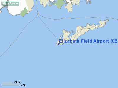
Elizabeth Field (IATA: FID, FAA LID: 0B8) is a public use airport located eight nautical miles (15 km) southeast of the central business district of Fishers Island, in Suffolk County, New York, United States. It is owned by the Town of Southold. According to the FAA's National Plan of Integrated Airport Systems for 2009-2013, Elizabeth Field is classified as a general aviation airport.
Located on the western end of Fishers Island, the airfield saw military use during World War II as part of Fort H. G. Wright.
Facilities and aircraft
Elizabeth Field covers an area of 122 acres (49 ha) at an elevation of 9 feet (3 m) above mean sea level. It has two asphalt paved runways: 12/30 is 2,328 by 100 feet (710 x 30 m) and 7/25 is 1,792 by 75 feet (546 x 23 m).
For the 12-month period ending September 27, 2007, the airport had 2,125 aircraft operations, an average of 177 per month: 52% air taxi, 47% general aviation and 1% military. At that time there were 6 aircraft based at this airport: 67% single-engine and 33% multi-engine.
The above content comes from Wikipedia and is published under free licenses – click here to read more.
Location & QuickFacts
| FAA Information Effective: | 2008-09-25 |
| Airport Identifier: | 0B8 |
| Airport Status: | Operational |
| Longitude/Latitude: | 072-01-53.8010W/41-15-04.7090N
-72.031611/41.251308 (Estimated) |
| Elevation: | 9 ft / 2.74 m (Surveyed) |
| Land: | 122 acres |
| From nearest city: | 8 nautical miles SE of Fishers Island, NY |
| Location: | Suffolk County, NY |
| Magnetic Variation: | 14W (1980) |
Owner & Manager
| Ownership: | Publicly owned |
| Owner: | Town Of Southold |
| Address: | Po Box H
Fishers Island, NY 06390 |
| Phone number: | 631-765-1800 |
| Manager: | Thomas Doherty, Fisher Is. Ferry Co |
| Address: | Po Box H
Fishers Island, NY 06390 |
| Phone number: | 631-788-7763
OR 516-788-7005 WHEN ATTENDED. |
Airport Operations and Facilities
| Airport Use: | Open to public |
| Wind indicator: | Yes |
| Segmented Circle: | No |
| Control Tower: | No |
| Lighting Schedule: | RDO-CTL
ACTVT MIRL RYS 07/25 & 12/30; PAPI RYS 07 & 25 & 12 & 30 - CTAF. |
| Landing fee charge: | Yes |
| Sectional chart: | New York |
| Region: | AEA - Eastern |
| Boundary ARTCC: | ZBW - Boston |
| Tie-in FSS: | BDR - Bridgeport |
| FSS on Airport: | No |
| FSS Toll Free: | 1-800-WX-BRIEF |
| NOTAMs Facility: | BDR (NOTAM-d service avaliable) |
| Federal Agreements: | NP |
Airport Communications
| CTAF: | 122.800 |
| Unicom: | 122.800 |
Airport Services
| Airframe Repair: | NONE |
| Power Plant Repair: | NONE |
| Bottled Oxygen: | NONE |
| Bulk Oxygen: | NONE |
Runway Information
Runway 07/25
| Dimension: | 1792 x 75 ft / 546.2 x 22.9 m |
| Surface: | ASPH, |
| Edge Lights: | Medium
MIRL RY 07/25 OTS INDEFLY. |
| |
Runway 07 |
Runway 25 |
| Longitude: | 072-02-04.3100W | 072-01-43.7400W |
| Latitude: | 41-15-04.0560N | 41-15-12.5720N |
| Elevation: | 5.00 ft | 8.00 ft |
| Alignment: | 61 | 127 |
| Traffic Pattern: | Left | Left |
| Markings: | Basic, Good Condition | Basic, Good Condition |
| Crossing Height: | 24.00 ft | 20.00 ft |
| VASI: | 2-light PAPI on left side | 2-light PAPI on left side |
| Visual Glide Angle: | 3.75° | 3.00° |
| Runway End Identifier: | Yes
REIL OTS INDEFLY. | Yes
RY 25 REIL OTS INDEFLY. |
| Centerline Lights: | No | No |
| Touchdown Lights: | No | No |
| Obstruction: | 3 ft other, 201.0 ft from runway, 81 ft right of centerline
RY 07 HAS +4 EMBANKMENT & SAND DUNE 170 FT FM THLD; +3 FT ROCK SEA WALL, 135 FT FM THLD, 100 FT RT. | 61 ft hill, 2061.0 ft from runway, 30 ft left of centerline, 30:1 slope to clear
+15 FT BUNKER 75 FT R OF CNTRLN 175 FT FM THLD. |
|
Runway 12/30
| Dimension: | 2328 x 100 ft / 709.6 x 30.5 m |
| Surface: | ASPH, |
| Edge Lights: | Medium
MIRL RY 07/25 OTS INDEFLY. |
| |
Runway 12 |
Runway 30 |
| Longitude: | 072-02-08.5930W | 072-01-38.6640W |
| Latitude: | 41-15-09.4160N | 41-15-05.0720N |
| Elevation: | 7.00 ft | 4.00 ft |
| Alignment: | 101 | 127 |
| Traffic Pattern: | Left | Left |
| Markings: | Basic, Good Condition | Basic, Good Condition |
| Crossing Height: | 21.00 ft | 20.00 ft |
| VASI: | 2-light PAPI on left side
RY 12 PAPI OTS INDEFLY. | 2-light PAPI on right side
RY 30 PAPI OTS INDEFLY. |
| Visual Glide Angle: | 3.00° | 3.00° |
| Runway End Identifier: | Yes | Yes |
| Centerline Lights: | No | No |
| Touchdown Lights: | No | No |
| Obstruction: | , 50:1 slope to clear | 3 ft other, 201.0 ft from runway, 75 ft left of centerline
RY 30 HAS +3 FT SEAWALL AT THLD, 70 FT L. |
|
Radio Navigation Aids
| ID |
Type |
Name |
Ch |
Freq |
Var |
Dist |
| HF | NDB | Lomis | | 244.00 | 15W | 35.3 nm |
| MMK | NDB | Meriden | | 238.00 | 14W | 39.2 nm |
| SFZ | NDB | Central | | 241.00 | 15W | 47.0 nm |
| FOK | TACAN | Suffolk Co | 047X | | 13W | 36.9 nm |
| GON | VOR/DME | Groton | 45Y | 110.85 | 14W | 4.8 nm |
| ORW | VOR/DME | Norwich | 037X | 110.00 | 14W | 18.4 nm |
| SEY | VOR/DME | Sandy Point | 125X | 117.80 | 15W | 21.2 nm |
| MAD | VOR/DME | Madison | 041X | 110.40 | 13W | 30.1 nm |
| HFD | VOR/DME | Hartford | 096X | 114.90 | 13W | 33.0 nm |
| HVN | VOR/DME | New Haven | 035X | 109.80 | 13W | 38.6 nm |
| CCC | VOR/DME | Calverton | 119X | 117.20 | 13W | 39.8 nm |
| PUT | VOR/DME | Putnam | 121X | 117.40 | 14W | 43.2 nm |
| BDR | VOR/DME | Bridgeport | 25X | 108.80 | 12W | 49.7 nm |
| HTO | VORTAC | Hampton | 083X | 113.60 | 13W | 23.8 nm |
| PVD | VORTAC | Providence | 103X | 115.60 | 14W | 39.3 nm |
| GON | VOT | Groton | | 110.25 | | 4.5 nm |
| PVD | VOT | Providence | | 108.20 | | 39.3 nm |
| HFD | VOT | Hartford | | 108.20 | | 40.3 nm |
| BDR | VOT | Bridgeport | | 109.25 | | 49.8 nm |
Remarks
- APR 16, 1959 MIL FAC TURNED OVER TO COM.
Images and information placed above are from
http://www.airport-data.com/airport/0B8/
We thank them for the data!
| General Info
|
| Country |
United States
|
| State |
NEW YORK
|
| FAA ID |
0B8
|
| Latitude |
41-15-04.709N
|
| Longitude |
072-01-53.801W
|
| Elevation |
9 feet
|
| Near City |
FISHERS ISLAND
|
We don't guarantee the information is fresh and accurate. The data may
be wrong or outdated.
For more up-to-date information please refer to other sources.
|
|


