 |
|
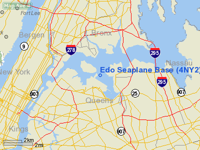
Edo Seaplane Base Airport |
Location & QuickFacts
| FAA Information Effective: | 2008-09-25 |
| Airport Identifier: | 4NY2 |
| Airport Status: | Operational |
| Longitude/Latitude: | 073-51-58.4870W/40-47-00.3640N
-73.866246/40.783434 (Estimated) |
| Elevation: | 0 ft / 0.00 m (Estimated) |
| Land: | 0 acres |
| From nearest city: | 0 nautical miles N of College Point, NY |
| Location: | Queens County, NY |
| Magnetic Variation: | 13W (1985) |
Owner & Manager
| Ownership: | Privately owned |
| Owner: | Edo Corp. |
| Address: |
|
| Manager: | J.j. Frey, Float Operations |
| Address: | 14-04 111 St
College Point, NY 11356 |
| Phone number: | 718-445-6000 |
Airport Operations and Facilities
| Airport Use: | Private |
| Wind indicator: | Yes |
| Segmented Circle: | No |
| Control Tower: | No |
| Landing fee charge: | No |
| Sectional chart: | New York |
| Region: | AEA - Eastern |
| Boundary ARTCC: | ZNY - New York |
| Tie-in FSS: | ISP - New York |
| FSS on Airport: | No |
| FSS Toll Free: | 1-800-WX-BRIEF |
Airport Services
| Airframe Repair: | NONE |
| Power Plant Repair: | NONE |
Runway Information
Runway N/S
| Dimension: | 5000 x 500 ft / 1524.0 x 152.4 m |
| Surface: | WATER, |
| |
Runway N |
Runway S |
| Traffic Pattern: | Left | Left |
|
Runway NE/SW
| Dimension: | 10000 x 500 ft / 3048.0 x 152.4 m |
| Surface: | WATER, |
| |
Runway NE |
Runway SW |
| Traffic Pattern: | Left | Left |
|
Runway NW/SE
| Dimension: | 10000 x 500 ft / 3048.0 x 152.4 m |
| Surface: | WATER, |
| |
Runway NW |
Runway SE |
| Traffic Pattern: | Left | Left |
|
Radio Navigation Aids
| ID |
Type |
Name |
Ch |
Freq |
Var |
Dist |
| EWR | FAN MARKER | Maryann | | | 11W | 15.4 nm |
| SKU | FAN MARKER | Stanwyck | | | 12W | 45.5 nm |
| OGY | NDB | Bridge | | 414.00 | 12W | 13.0 nm |
| PNJ | NDB | Paterson | | 347.00 | 12W | 16.2 nm |
| BBN | NDB | Babylon | | 275.00 | 14W | 22.9 nm |
| CAT | NDB | Chatham | | 254.00 | 11W | 25.8 nm |
| OP | NDB | Old Field Point Light | | 316.00 | 13W | 35.9 nm |
| SW | NDB | Neely | | 335.00 | 14W | 45.3 nm |
| SKU | NDB | Stanwyck | | 261.00 | 12W | 45.5 nm |
| PO | NDB | Meier | | 403.00 | 12W | 47.8 nm |
| NEL | NDB | Lakehurst | | 396.00 | 13W | 49.3 nm |
| NEL | UHF/NDB | Lakehurst | | 274.80 | 13W | 49.3 nm |
| LGA | VOR/DME | La Guardia | 078X | 113.10 | 12W | 0.6 nm |
| TEB | VOR/DME | Teterboro | 021X | 108.40 | 11W | 9.7 nm |
| JFK | VOR/DME | Kennedy | 106X | 115.90 | 12W | 10.0 nm |
| CRI | VOR/DME | Canarsie | 070X | 112.30 | 11W | 10.4 nm |
| DPK | VOR/DME | Deer Park | 124X | 117.70 | 12W | 25.6 nm |
| COL | VOR/DME | Colts Neck | 101X | 115.40 | 11W | 31.4 nm |
| CMK | VOR/DME | Carmel | 113X | 116.60 | 12W | 32.5 nm |
| BDR | VOR/DME | Bridgeport | 25X | 108.80 | 12W | 40.6 nm |
| SBJ | VOR/DME | Solberg | 076X | 112.90 | 10W | 41.7 nm |
| BWZ | VOR/DME | Broadway | 089X | 114.20 | 11W | 43.5 nm |
| STW | VOR/DME | Stillwater | 033X | 109.60 | 11W | 47.3 nm |
| CCC | VOR/DME | Calverton | 119X | 117.20 | 13W | 49.3 nm |
| HUO | VOR/DME | Huguenot | 108X | 116.10 | 11W | 50.0 nm |
| SAX | VORTAC | Sparta | 104X | 115.70 | 11W | 35.0 nm |
| RBV | VORTAC | Robbinsville | 085X | 113.80 | 10W | 45.2 nm |
| JFK | VOT | Kennedy | | 115.10 | | 9.8 nm |
| ISP | VOT | Long Island Mac Arthur | | 109.40 | | 35.1 nm |
| BDR | VOT | Bridgeport | | 109.25 | | 40.6 nm |
Remarks
- THIS IS A PVT FAC USED TO SUPPORT EDOS SPB OPERN.
Images and information placed above are from
http://www.airport-data.com/airport/4NY2/
We thank them for the data!
| General Info
|
| Country |
United States
|
| State |
NEW YORK
|
| FAA ID |
4NY2
|
| Latitude |
40-47-00.364N
|
| Longitude |
073-51-58.487W
|
| Elevation |
0 feet
|
| Near City |
COLLEGE POINT
|
We don't guarantee the information is fresh and accurate. The data may
be wrong or outdated.
For more up-to-date information please refer to other sources.
|
|


