|
|
| East Hampton Airport |
 |
| IATA: HTO – ICAO: KHTO – FAA LID: HTO |
| Summary |
| Operator |
Town of East Hampton |
| Location |
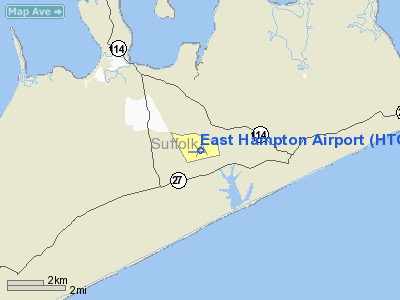
Wainscott, New York |
| Elevation AMSL |
56 ft / 17.1 m |
| Coordinates |
40°57′34″N 072°15′07″W / 40.95944°N 72.25194°W / 40.95944; -72.25194Coordinates: 40°57′34″N 072°15′07″W / 40.95944°N 72.25194°W / 40.95944; -72.25194 |
| Runways |
| Direction |
Length |
Surface |
| ft |
m |
| 10/28 |
4,255 |
1,297 |
Asphalt |
| 16/34 |
2,223 |
678 |
Asphalt |
4/22
CLOSED |
2,501 |
762 |
Asphalt |
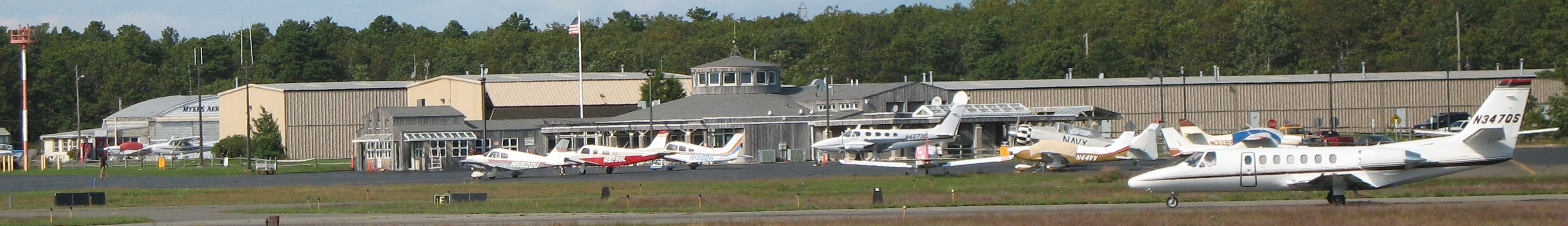
East Hampton Airport (IATA: HTO, ICAO: KHTO, FAA LID: HTO) is a public airport in Wainscott, New York, three miles (5 km) west of the central business district of the village of East Hampton, in Suffolk County, New York, USA. It is owned and operated by the Town of East Hampton.
There is considerable debate about the airport which is prominently used by private jets visiting the Hamptons. Residents of newly built houses around the airport have complained about the noise. Other residents have complained about the money spent on the airport. Much of the debate now centers on whether to repair the 2,501-foot (762 m) runway 4/22 which is cracked with vegetation and is currently closed.
Noise from helicopters has also generated controversy. In the summer of 2007 US Helicopter announced plans for scheduled service between the East 34th Street Heliport and the airport (leaving on Friday afternoons and returning on Sunday evenings) with a roundtrip ticket cost of $1,600. In response United States Senator Charles Schumer introduced legislation in July 2007 requiring the Federal Aviation Agency "to study helicopter traffic over Long Island, and report within 90 days on ways to reduce noise and divert the flight paths from homes." The New York Times noted that East Hampton Airport is the most popular destination for helicopters from New York City and that there were 2,400 helicopter arrivals and departures from January to June 2007. James L. Brundige, the airport’s manager, said helicopter flights had doubled in the past decade.
Trump Air provided regularly scheduled helicopter service in the late 1980s and early 1990s. The last scheduled fixed wing airline was East Hampton Airlines which now offers chartered service.
As per Federal Aviation Administration records, the airport had 420 passenger boardings (enplanements) in calendar year 2004 and 103 enplanements in 2005. According to the FAA's National Plan of Integrated Airport Systems for 2007–2011, East Hampton is classified as a general aviation airport.
Marine One was based at the airport for one week in August 1998 and 1999 during week-long visits by Bill Clinton and Hillary Clinton to the Georgica Pond home of director Steven Spielberg. Clinton conducted a fundraiser in a hangar at the airport in 1999.
The PBS children's television show It's a Big Big World produced by Mitchell Kriegman is produced at Wainscott Studios which is the industrial park associated with the airport.
Cape Air is thinking about launching service to East Hampton Airport Summer 2010 from either Boston, New York, or Martha's Vineyard. Facilities
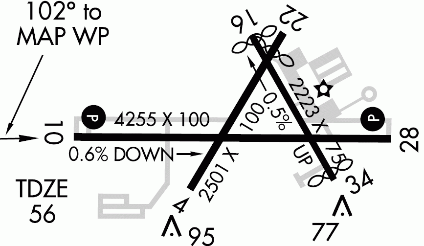
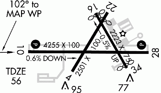
East Hampton Airport covers 570 acres (231 ha) and has three runways:
- Runway 10/28: 4,255 x 100 ft. (1,297 x 30 m), Surface: Asphalt
- Runway 4/22: 2,501 x 100 ft. (762 x 30 m), Surface: Asphalt (currently closed)
- Runway 16/34: 2,223 x 75 ft. (678 x 23 m), Surface: Asphalt
Airlines
- US Helicopter (East 34th St. Heliport) (seasonal) [temporarily suspended]
The above content comes from Wikipedia and is published under free licenses – click here to read more.
Location & QuickFacts
| FAA Information Effective: | 2008-09-25 |
| Airport Identifier: | HTO |
| Airport Status: | Operational |
| Longitude/Latitude: | 072-15-06.7000W/40-57-34.5000N
-72.251861/40.959583 (Estimated) |
| Elevation: | 55 ft / 16.76 m (Surveyed) |
| Land: | 570 acres |
| From nearest city: | 3 nautical miles W of East Hampton, NY |
| Location: | Suffolk County, NY |
| Magnetic Variation: | 13W (1980) |
Owner & Manager
| Ownership: | Publicly owned |
| Owner: | Town Of East Hampton |
| Address: | 159 Pantigo Rd
East Hampton, NY 11937 |
| Phone number: | 631-324-4140 |
| Manager: | Jim Brundige |
| Address: | Po Box 836
East Hampton, NY 11937 |
| Phone number: | 631-537-1130 |
Airport Operations and Facilities
| Airport Use: | Open to public |
| Wind indicator: | Yes |
| Segmented Circle: | Yes |
| Control Tower: | No |
| Lighting Schedule: | DUSK-DAWN
ACTVT MIRL RY 10/28; PAPI RYS 10 & 28; REIL RYS 10 & 28 - CTAF.. |
| Beacon Color: | Clear-Green (lighted land airport) |
| Landing fee charge: | Yes
LNDG FEE FOR ALL TRANSIENT ACFT TO INCLUDE TOUCH AND GO OPERATIONS. |
| Sectional chart: | New York |
| Region: | AEA - Eastern |
| Boundary ARTCC: | ZBW - Boston |
| Responsible ARTCC: | ZNY - New York |
| Tie-in FSS: | ISP - New York |
| FSS on Airport: | No |
| FSS Toll Free: | 1-800-WX-BRIEF
FOR LOCAL CALL TO FSS DIAL 737-1000. |
| NOTAMs Facility: | HTO (NOTAM-d service avaliable) |
| Federal Agreements: | NGVY |
Airport Communications
| CTAF: | 122.700 |
| Unicom: | 122.700 |
Airport Services
| Fuel available: | 100LLA |
| Airframe Repair: | MAJOR |
| Power Plant Repair: | MAJOR |
| Bottled Oxygen: | NONE |
| Bulk Oxygen: | NONE |
Runway Information
Runway 04/22
| Dimension: | 2507 x 100 ft / 764.1 x 30.5 m |
| Surface: | ASPH, Poor Condition
RY 04/22 CRACKED WITH VEGETATION GROWING THROUGH.
RY 16/34 CRACKED WITH VEGETATION GROWING THRU, STANDING WATER. |
| Weight Limit: | Single wheel: 8000 lbs. |
| |
Runway 04 |
Runway 22 |
| Longitude: | 072-15-16.8367W | 072-15-01.1511W |
| Latitude: | 40-57-25.1129N | 40-57-46.8462N |
| Elevation: | 45.00 ft | 40.00 ft |
| Alignment: | 29 | 127 |
| Traffic Pattern: | Left | Left |
| Markings: | Basic, Good Condition | Basic, Good Condition |
| Displaced threshold: | 0.00 ft | 380.00 ft |
| Runway End Identifier: | No | No |
| Centerline Lights: | No | No |
| Touchdown Lights: | No | No |
|
Runway 10/28
| Dimension: | 4255 x 100 ft / 1296.9 x 30.5 m |
| Surface: | ASPH, Good Condition
RY 04/22 CRACKED WITH VEGETATION GROWING THROUGH.
RY 16/34 CRACKED WITH VEGETATION GROWING THRU, STANDING WATER. |
| Weight Limit: | Single wheel: 60000 lbs. |
| Edge Lights: | Medium |
| |
Runway 10 |
Runway 28 |
| Longitude: | 072-15-37.0828W | 072-14-41.6308W |
| Latitude: | 40-57-31.9776N | 40-57-32.7662N |
| Elevation: | 55.00 ft | 30.00 ft |
| Alignment: | 89 | 127 |
| Traffic Pattern: | Left | Left |
| Markings: | Non-precision instrument, Fair Condition | Non-precision instrument, Fair Condition |
| Crossing Height: | 55.00 ft | 0.00 ft |
| VASI: | 2-light PAPI on left side | 2-light PAPI on right side |
| Visual Glide Angle: | 3.00° | 3.00° |
| Runway End Identifier: | Yes | Yes |
| Centerline Lights: | No | No |
| Touchdown Lights: | No | No |
| Obstruction: | 65 ft trees, 1406.0 ft from runway, 18:1 slope to clear | 33 ft pole, 328.0 ft from runway, 266 ft right of centerline, 3:1 slope to clear |
|
Runway 16/34
| Dimension: | 2223 x 75 ft / 677.6 x 22.9 m |
| Surface: | ASPH, Fair Condition
RY 04/22 CRACKED WITH VEGETATION GROWING THROUGH.
RY 16/34 CRACKED WITH VEGETATION GROWING THRU, STANDING WATER. |
| Weight Limit: | Single wheel: 8000 lbs. |
| |
Runway 16 |
Runway 34 |
| Longitude: | 072-15-06.2711W | 072-14-51.3882W |
| Latitude: | 40-57-46.2739N | 40-57-27.4239N |
| Elevation: | 41.00 ft | 29.00 ft |
| Alignment: | 127 | 127 |
| Traffic Pattern: | Left | Left |
| Markings: | Basic, Good Condition | Basic, Good Condition |
| Displaced threshold: | 57.00 ft | 106.00 ft |
| Runway End Identifier: | No | No |
| Centerline Lights: | No | No |
| Touchdown Lights: | No | No |
| Obstruction: | 16 ft road, 207.0 ft from runway
RWY 16 APCH RATIO 17:1 TO DSPLCD THLD.
RY 16 +6 FT HILL 199 FT RM THLD 62 FT RIGHT. | 23 ft road, 340.0 ft from runway, 6:1 slope to clear
APCH RATIO 19:1 TO DSPLCD THLD. |
|
Radio Navigation Aids
| ID |
Type |
Name |
Ch |
Freq |
Var |
Dist |
| OP | NDB | Old Field Point Light | | 316.00 | 13W | 39.3 nm |
| MMK | NDB | Meriden | | 238.00 | 14W | 42.1 nm |
| HF | NDB | Lomis | | 244.00 | 15W | 44.0 nm |
| FOK | TACAN | Suffolk Co | 047X | | 13W | 18.8 nm |
| GON | VOR/DME | Groton | 45Y | 110.85 | 14W | 24.1 nm |
| CCC | VOR/DME | Calverton | 119X | 117.20 | 13W | 24.9 nm |
| MAD | VOR/DME | Madison | 041X | 110.40 | 13W | 29.2 nm |
| SEY | VOR/DME | Sandy Point | 125X | 117.80 | 15W | 33.1 nm |
| HVN | VOR/DME | New Haven | 035X | 109.80 | 13W | 34.0 nm |
| ORW | VOR/DME | Norwich | 037X | 110.00 | 14W | 37.6 nm |
| BDR | VOR/DME | Bridgeport | 25X | 108.80 | 12W | 41.4 nm |
| HFD | VOR/DME | Hartford | 096X | 114.90 | 13W | 43.1 nm |
| DPK | VOR/DME | Deer Park | 124X | 117.70 | 12W | 48.9 nm |
| HTO | VORTAC | Hampton | 083X | 113.60 | 13W | 3.8 nm |
| GON | VOT | Groton | | 110.25 | | 23.8 nm |
| ISP | VOT | Long Island Mac Arthur | | 109.40 | | 39.7 nm |
| BDR | VOT | Bridgeport | | 109.25 | | 41.4 nm |
| HFD | VOT | Hartford | | 108.20 | | 50.0 nm |
Remarks
- DEER ON & INVOF ARPT.
- NOISE ABATEMENT PROCEDURES IN EFFECT CTC AIRPORT MANAGEMENT FOR DETAILS AT (631-537-1130).
- RY 04/22 CLSD INDEFLY.
Images and information placed above are from
http://www.airport-data.com/airport/HTO/
We thank them for the data!
| General Info
|
| Country |
United States
|
| State |
NEW YORK
|
| FAA ID |
HTO
|
| Latitude |
40-57-34.480N
|
| Longitude |
072-15-06.662W
|
| Elevation |
56 feet
|
| Near City |
EAST HAMPTON
|
We don't guarantee the information is fresh and accurate. The data may
be wrong or outdated.
For more up-to-date information please refer to other sources.
|
|