|
|
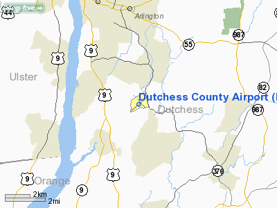
| Dutchess County Airport |
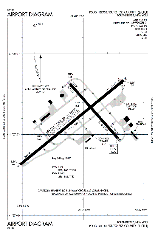 |
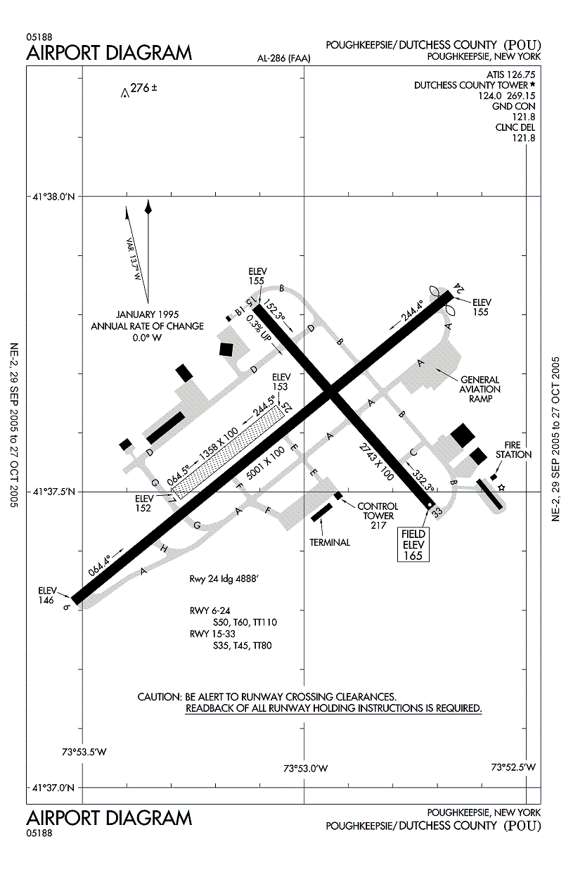
| FAA airport diagram |
| IATA: POU – ICAO: KPOU – FAA LID: POU |
| Summary |
| Airport type |
Public |
| Owner |
Dutchess County |
| Serves |
Poughkeepsie, New York |
| Elevation AMSL |
165 ft / 50 m |
| Coordinates |
41°37′36″N 073°53′03″W / 41.62667°N 73.88417°W / 41.62667; -73.88417 |
| Runways |
| Direction |
Length |
Surface |
| ft |
m |
| 6/24 |
5,001 |
1,524 |
Asphalt |
| 15/33 |
2,743 |
836 |
Asphalt/Concrete |
| 7/25 |
1,358 |
414 |
Turf/Dirt |
| Statistics (2007) |
| Aircraft operations |
98,342 |
| Based aircraft |
198 |
| Source: Federal Aviation Administration |
Dutchess County Airport (IATA: POU, ICAO: KPOU, FAA LID: POU) is a county-owned public-use airport located on State Route 376 in the Town of Wappinger, Dutchess County, New York, United States, four miles (6 km) south of the central business district of Poughkeepsie. It is sometimes called Poughkeepsie Airport, which gives it the code POU. The airport provides corporate and general aviation transportation services. History
Dutchess County Airport was built by the United States Department of Commerce in the 1930s and was used for pilot training during World War II by the US Army Air Forces. Known as New Hackensack Field at the time for the nearby hamlet, it was used by students at the United States Military Academy and as an extension of military training conducted at Stewart Field. On June 17, 1942, British Prime Minister Winston Churchill flew from Naval Air Station Anacostia to New Hackensack Field, where he was met by President Franklin D. Roosevelt, who had driven from his Hyde Park home.
After the Second World War, the airport was turned over to the county for the sum of $1 and guarantees that it would remain open as part of the Surplus Property Act of 1944 by the War Assets Administration. It was then used for general aviation. IBM built a hangar and based its corporate aircraft and helicopters at the airport, including Gulfstream II jets in the 1970s–1980s. In the 1970s, Cessna built and ran a Cessna Citation maintenance facility on the airport grounds.
Scheduled air service
In the 1950s, scheduled air carrier service was provided at Dutchess County Airport by Colonial Airlines. Its service to POU in 1956 was a DC-3 aircraft from New York City's LaGuardia Airport, making an 11:50 am Monday-Friday flag stop enroute to Montreal and Ottawa, Canada, with intermediate stops at Albany, New York, and Burlington, Vermont.
In the 1960s–1980s, the airport had commuter airline service by Command Airways, Colgan Airways, Air North, and others. Command Airways, later known as American Eagle Airlines, maintained its hub, executive offices, and maintenance facilities at the airport. Command qualified the ATR 72 with the Federal Aviation Administration (FAA) for U.S. flight operations at the airport. In September 1980, the airport opened its current 16,700 sq ft (1,551 m) terminal building for airline passengers.
When Stewart International Airport, which is located just across the Hudson River, started commercial operations in 1990, most commercial airline service ended at Dutchess County Airport. POU lost its last commercial service on August 12, 2001, when Continental Connection carrier CommutAir discontinued its flights to Burlington International Airport, Vermont.
Facilities and aircraft
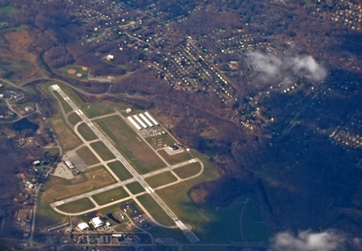 | |
Aerial view of the airport in November 2008 |
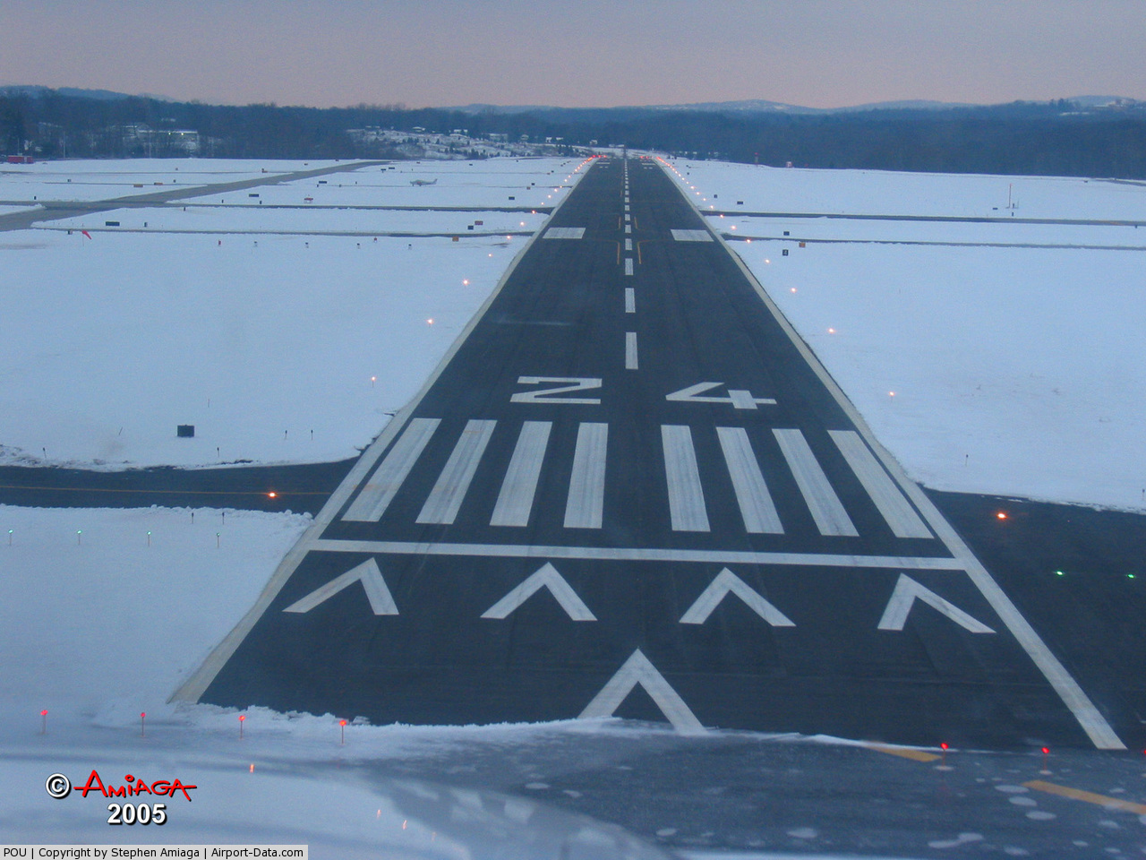
Dutchess County Airport covers an area of 640 acres (259 ha) which contains three runways, two of which are paved. The main runway (6-24) is 5,001 by 100 feet (1,524 by 30 m) long and is equipped with an ILS system to the northeast-facing runway along with a medium intensity approach light system with runway alignment lights. The crosswind runway (15-33) was originally 3,003 feet (915 m) long but is now shortened to 2,743 by 100 feet (836 by 30 m) due to displaced thresholds at both ends. A turf/dirt runway (7-25) measures 1,358 by 100 feet (414 by 30 m).
A Flight Service Station was opened at the airport, but closed during the 1990s. In the 1970s, a control tower was constructed by the FAA, which currently operates it 14 hours per day. In 2004, the airport received $1 million dollars from the Federal Aviation Administration for improvements in safety and runway rehabilitation.
For the 12-month period ending August 31, 2007, the airport had 98,342 aircraft operations, an average of 269 per day: 99% general aviation, 1% air taxi, <1% military. At that time there were 198 aircraft based at this airport: 80% single-engine, 11% multi-engine, 1% jet, 8% helicopter, 1% military.
The above content comes from Wikipedia and is published under free licenses – click here to read more.
 |
(Click on the photo to enlarge) |
Location & QuickFacts
| FAA Information Effective: | 2008-09-25 |
| Airport Identifier: | POU |
| Airport Status: | Operational |
| Longitude/Latitude: | 073-53-03.0930W/41-37-35.6980N
-73.884192/41.626583 (Estimated) |
| Elevation: | 165 ft / 50.29 m (Surveyed) |
| Land: | 640 acres |
| From nearest city: | 4 nautical miles S of Poughkeepsie, NY |
| Location: | Dutchess County, NY |
| Magnetic Variation: | 12W (1975) |
Owner & Manager
| Ownership: | Publicly owned |
| Owner: | Dutchess County |
| Address: | 22 Market St
Poughkeepsie, NY 12601 |
| Phone number: | 845-486-2000 |
| Manager: | Edward A. Rose |
| Address: | 263 New Hackensack Rd
Wappingers Falls, NY 12590 |
| Phone number: | 845-463-6000 |
Airport Operations and Facilities
| Airport Use: | Open to public |
| Wind indicator: | Yes |
| Segmented Circle: | No |
| Control Tower: | Yes |
| Lighting Schedule: | DUSK-DAWN
WHEN ATCT CLSD ACTIVATE HIRL RY 06/24; REILS RY 24; MALSR RY 06 - CTAF. |
| Beacon Color: | Clear-Green (lighted land airport) |
| Landing fee charge: | Yes
LANDING FEE FOR MULTI-ENGINE AIRCRAFT. |
| Sectional chart: | New York |
| Region: | AEA - Eastern |
| Boundary ARTCC: | ZBW - Boston |
| Responsible ARTCC: | ZNY - New York |
| Tie-in FSS: | ISP - New York |
| FSS on Airport: | No |
| FSS Toll Free: | 1-800-WX-BRIEF |
| NOTAMs Facility: | POU (NOTAM-d service avaliable) |
| Certification type/date: | IV A U 01/198
PPR 24 HRS FOR ACR OPNS WITH MORE THAN 30 PSGR SEATS; CALL AMGR 845-463-6000. INDEX "B" COVERAGE IS PRVDD. |
| Federal Agreements: | NGRY |
Airport Communications
| CTAF: | 124.000 |
| Unicom: | 122.950 |
Airport Services
| Fuel available: | 100LLA |
| Airframe Repair: | MAJOR |
| Power Plant Repair: | MAJOR |
Runway Information
Runway 06/24
| Dimension: | 5001 x 100 ft / 1524.3 x 30.5 m |
| Surface: | ASPH, |
| Surface Treatment: | Saw-cut or plastic Grooved |
| Weight Limit: | Single wheel: 50000 lbs.
Dual wheel: 60000 lbs.
Dual tandem wheel: 110000 lbs. |
| Edge Lights: | High |
| |
Runway 06 |
Runway 24 |
| Longitude: | 073-53-31.2295W | 073-52-40.2144W |
| Latitude: | 41-37-18.8937N | 41-37-50.1342N |
| Elevation: | 146.00 ft | 154.00 ft |
| Alignment: | 51 | 127 |
| ILS Type: | ILS
| |
| Traffic Pattern: | Left | Left |
| Markings: | Precision instrument, Good Condition | Non-precision instrument, Good Condition |
| Crossing Height: | 57.00 ft | 57.00 ft |
| Displaced threshold: | 0.00 ft | 113.00 ft |
| VASI: | 4-light PAPI on left side | 4-light PAPI on left side |
| Visual Glide Angle: | 3.00° | 3.25° |
| Approach lights: | MALSR | |
| Runway End Identifier: | | Yes |
| Obstruction: | 18 ft tree, 380.0 ft from runway, 300 ft left of centerline, 10:1 slope to clear | 71 ft tree, 210.0 ft from runway, 400 ft left of centerline
RY 24 APCH SLOPE 4:1 TO DSPLCD THR. |
| Decleard distances: | Take off run available 5001.00 ft
Take off distance available 5001.00 ft
Actual stop distance available 5001.00 ft
Landing distance available 5001.00 ft
| Take off run available 5001.00 ft
Take off distance available 5001.00 ft
Actual stop distance available 5001.00 ft
Landing distance available 4888.00 ft
|
|
Runway 07/25
| Dimension: | 1358 x 100 ft / 413.9 x 30.5 m |
| Surface: | TURF-DIRT, Good Condition |
| |
Runway 07 |
Runway 25 |
| Longitude: | 073-53-17.4332W | 073-53-03.5803W |
| Latitude: | 41-37-29.9131N | 41-37-38.3918N |
| Alignment: | 51 | 127 |
| Traffic Pattern: | Left | Left |
| Markings: | Nonstandard,
EDGES MARKED WITH REFLECTORS. | , |
| Obstruction: | , 50:1 slope to clear | 24 ft ant, 215.0 ft from runway, 90 ft right of centerline, 8:1 slope to clear |
| Decleard distances: | Take off run available 1358.00 ft
Take off distance available 1358.00 ft
Actual stop distance available 1358.00 ft
Landing distance available 1358.00 ft
| Take off run available 1358.00 ft
Take off distance available 1358.00 ft
Actual stop distance available 1358.00 ft
Landing distance available 1358.00 ft
|
|
Runway 15/33
| Dimension: | 2743 x 100 ft / 836.1 x 30.5 m |
| Surface: | ASPH-CONC, |
| Weight Limit: | Single wheel: 35000 lbs.
Dual wheel: 45000 lbs.
Dual tandem wheel: 80000 lbs. |
| Edge Lights: | Medium |
| |
Runway 15 |
Runway 33 |
| Longitude: | 073-53-06.5520W | 073-52-42.7070W |
| Latitude: | 41-37-48.7980N | 41-37-28.4460N |
| Elevation: | 0.00 ft | 163.00 ft |
| Alignment: | 127 | 127 |
| Traffic Pattern: | Left | Left |
| Markings: | Basic, Good Condition | Basic, Good Condition |
| Crossing Height: | 0.00 ft | 64.00 ft |
| VASI: | | 4-box on left side
USE OF VASI RESTRICTED TO CATEGORY A ACFT ONLY. |
| Visual Glide Angle: | 0.00° | 3.75° |
| Runway End Identifier: | | Yes |
| Obstruction: | 51 ft trees, 900.0 ft from runway, 100 ft right of centerline, 13:1 slope to clear | 37 ft trees, 240.0 ft from runway, 200 ft left of centerline, 1:1 slope to clear
RY 33 +13 FT OBSTRUCTION LGTD POLE 160 FT FM THLD 150 FT LEFT. |
| Decleard distances: | Take off run available 2743.00 ft
Take off distance available 2743.00 ft
Actual stop distance available 2743.00 ft
Landing distance available 2743.00 ft
| Take off run available 2743.00 ft
Take off distance available 2743.00 ft
Actual stop distance available 2743.00 ft
Landing distance available 2743.00 ft
|
|
Radio Navigation Aids
| ID |
Type |
Name |
Ch |
Freq |
Var |
Dist |
| SKU | FAN MARKER | Stanwyck | | | 12W | 9.3 nm |
| GBR | FAN MARKER | Sheffield | | | 13W | 38.1 nm |
| PO | NDB | Meier | | 403.00 | 12W | 4.8 nm |
| SKU | NDB | Stanwyck | | 261.00 | 12W | 9.3 nm |
| SW | NDB | Neely | | 335.00 | 14W | 17.6 nm |
| TBY | NDB | Waterbury | | 257.00 | 14W | 33.8 nm |
| PFH | NDB | Philmont | | 272.00 | 13W | 38.3 nm |
| GBR | NDB | Great Barrington | | 395.00 | 14W | 39.7 nm |
| PNJ | NDB | Paterson | | 347.00 | 12W | 42.6 nm |
| MS | NDB | Monga | | 359.00 | 12W | 44.6 nm |
| MMK | NDB | Meriden | | 238.00 | 14W | 48.0 nm |
| IGN | VOR/DME | Kingston | 123X | 117.60 | 12W | 3.6 nm |
| PWL | VOR/DME | Pawling | 090X | 114.30 | 12W | 15.4 nm |
| CMK | VOR/DME | Carmel | 113X | 116.60 | 12W | 24.9 nm |
| HUO | VOR/DME | Huguenot | 108X | 116.10 | 11W | 34.4 nm |
| BDR | VOR/DME | Bridgeport | 25X | 108.80 | 12W | 44.2 nm |
| TEB | VOR/DME | Teterboro | 021X | 108.40 | 11W | 47.4 nm |
| SAX | VORTAC | Sparta | 104X | 115.70 | 11W | 44.7 nm |
| BDR | VOT | Bridgeport | | 109.25 | | 44.2 nm |
Remarks
- 50 FT DROP 100 FT FROM RY 06 THR.
- FOR AFTER HRS FUEL SERVICES, CONTACT BUSINESS OFFICE DURING BUSINESS HRS AT 845-463-6000.
- PPR ONE HR FOR AIR CARRIER OPS, 1030-1600.
- TWY B-1; 'G' T-HGR TAXILANE; AND 'J' T-HGR TAXILAND CLSD AIR CARRIER ACFT.
- ENGINEERED MATERIALS ARRESTING SYSTEM (EMAS) 250 FT IN LENGTH BY 121 FT WIDTH LOCATED DEP END RY 06.
- RY 15/33 CLSD TO ACR ACFT.
- NOISE ABATEMENT PROCEDURES IN EFFECT.
- BIRDS & DEER ON & INVOF ARPT.
- GROUND SOFT IN TIE DOWN AREAS.
- NO TGLS & NO PRACTICE INST APCHS FOR ACFT OVER 12500 LBS BETWEEN 2300-0700.
- RY 07/25 RESTRICTED TO ACFT LESS THAN 12500 LBS.
Images and information placed above are from
http://www.airport-data.com/airport/POU/
We thank them for the data!
| General Info
|
| Country |
United States
|
| State |
NEW YORK
|
| FAA ID |
POU
|
| Latitude |
41-37-35.800N
|
| Longitude |
073-53-02.800W
|
| Elevation |
165 feet
|
| Near City |
POUGHKEEPSIE
|
We don't guarantee the information is fresh and accurate. The data may
be wrong or outdated.
For more up-to-date information please refer to other sources.
|
|