 |
|
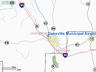
| Dansville Municipal Airport |
| IATA: DSV – ICAO: KDSV – FAA LID: DSV |
| Summary |
| Airport type |
Public |
| Owner |
Town of North Dansville |
| Serves |
Dansville, Livingston County, New York |
| Elevation AMSL |
662 ft / 202 m |
| Coordinates |
42°34′15″N 077°42′47″W / 42.57083°N 77.71306°W / 42.57083; -77.71306 |
| Runways |
| Direction |
Length |
Surface |
| ft |
m |
| 14/32 |
3,500 |
1,067 |
Asphalt |
| 18/36 |
2,443 |
745 |
Asphalt |
| Statistics (2007) |
| Aircraft operations |
48,050 |
| Based aircraft |
33 |
| Source: Federal Aviation Administration |
Dansville Municipal Airport (IATA: DSV, ICAO: KDSV, FAA LID: DSV) is a public use airport located one nautical mile (2 km) northwest of the central business district of Dansville, a village in Livingston County, New York, United States. It is owned by the Town of North Dansville. Facilities and aircraft
Dansville Municipal Airport covers an area of 162 acres (66 ha) at an elevation of 662 feet (202 m) above mean sea level. It has two asphalt paved runways: 14/32 which measures 3,500 x 100 feet (1,067 x 30 m) and 18/36 which measures 2,443 x 100 feet (745 x 30 m).
For the 12-month period ending August 8, 2007, the airport had 48,050 aircraft operations, an average of 131 per day: 98% general aviation, 2% air taxi and 1% military. At that time there were 33 aircraft based at this airport: 61% single-engine, 9% multi-engine and 30% glider.
Balloon Festival
Annually, around Labor Day weekend, the airport is the venue for the New York State Festival of Balloons. The first such event was held in 1981 and given the designation of New York's official festival in 1997, beating out similar festivals in Glens Falls and Poughkeepsie for the designation. As of 2007, it attracts about 35,000 visitors each year.
The above content comes from Wikipedia and is published under free licenses – click here to read more.
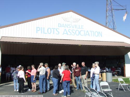 |
(Click on the photo to enlarge) |
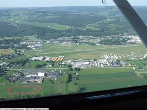 |
(Click on the photo to enlarge) |
Location & QuickFacts
| FAA Information Effective: | 2008-09-25 |
| Airport Identifier: | DSV |
| Airport Status: | Operational |
| Longitude/Latitude: | 077-42-46.9830W/42-34-15.2390N
-77.713051/42.570900 (Estimated) |
| Elevation: | 662 ft / 201.78 m (Surveyed) |
| Land: | 162 acres |
| From nearest city: | 1 nautical miles NW of Dansville, NY |
| Location: | Livingston County, NY |
| Magnetic Variation: | 09W (1975) |
Owner & Manager
| Ownership: | Publicly owned |
| Owner: | Town Of North Dansville |
| Address: | Town Hall Clara Barton St.
Dansville, NY 14437 |
| Phone number: | 585-335-2330 |
| Manager: | James Caneen |
| Address: | 176 Franklin Street
Dansville, NY 14437 |
| Phone number: | 585-335-2076 |
Airport Operations and Facilities
| Airport Use: | Open to public |
| Wind indicator: | Yes |
| Segmented Circle: | Yes |
| Control Tower: | No |
| Lighting Schedule: | DUSK-DAWN
ACTVT MIRL RYS 14/32 & 18/36 & VASI RYS 14 & 32 - 123.0. |
| Beacon Color: | Clear-Green (lighted land airport) |
| Landing fee charge: | No |
| Sectional chart: | Detroit |
| Region: | AEA - Eastern |
| Boundary ARTCC: | ZOB - Cleveland |
| Tie-in FSS: | BUF - Buffalo |
| FSS on Airport: | No |
| FSS Toll Free: | 1-800-WX-BRIEF |
| NOTAMs Facility: | DSV (NOTAM-d service avaliable) |
| Federal Agreements: | NGY3 |
Airport Communications
| CTAF: | 123.000 |
| Unicom: | 123.000 |
Airport Services
| Fuel available: | 100LL |
| Airframe Repair: | MAJOR |
| Power Plant Repair: | MAJOR |
| Bottled Oxygen: | NONE |
| Bulk Oxygen: | NONE |
Runway Information
Runway 14/32
| Dimension: | 3500 x 100 ft / 1066.8 x 30.5 m
RUNWAY SHORTENED 90 FT ON RWY 14 END AND 45 FT ON RWY 32 END |
| Surface: | ASPH, Good Condition |
| Weight Limit: | Single wheel: 30000 lbs.
MIN SFC AND BASE REQRMTS NOT MET FOR DUAL AND DUAL TANDEM GWTS BOTH RWYS 14-32 AND 18-36. |
| Edge Lights: | Medium |
| |
Runway 14 |
Runway 32 |
| Longitude: | 077-43-06.1000W | 077-42-29.4030W |
| Latitude: | 42-34-24.5880N | 42-34-03.2280N |
| Elevation: | 635.00 ft | 660.00 ft |
| Alignment: | 127 | 127 |
| Traffic Pattern: | Left | Left |
| Markings: | Basic, Good Condition | Basic, Good Condition |
| Crossing Height: | 53.00 ft | 53.00 ft |
| VASI: | 2-box on left side | 4-box on left side |
| Visual Glide Angle: | 3.00° | 4.00° |
| Runway End Identifier: | No | No |
| Obstruction: | 15 ft road, 340.0 ft from runway, 128 ft right of centerline, 9:1 slope to clear | 15 ft road, 280.0 ft from runway, 125 ft right of centerline, 5:1 slope to clear |
|
Runway 18/36
| Dimension: | 2443 x 100 ft / 744.6 x 30.5 m
RUNWAY SHORTENED 90 FT ON RWY 14 END AND 45 FT ON RWY 32 END |
| Surface: | ASPH, Fair Condition |
| Weight Limit: | Single wheel: 30000 lbs.
MIN SFC AND BASE REQRMTS NOT MET FOR DUAL AND DUAL TANDEM GWTS BOTH RWYS 14-32 AND 18-36. |
| Edge Lights: | Medium |
| |
Runway 18 |
Runway 36 |
| Longitude: | 077-42-48.1520W | 077-42-42.1410W |
| Latitude: | 42-34-27.1550N | 42-34-03.4660N |
| Elevation: | 633.00 ft | 655.00 ft |
| Alignment: | 127 | 127 |
| Traffic Pattern: | Left | Left |
| Markings: | Non-precision instrument, Poor Condition
A042 - RWY 18/36 MARKINGS FADED | Basic, Poor Condition
A042 - RWY 18/36 MARKINGS FADED |
| Displaced threshold: | 165.00 ft | 0.00 ft |
| Obstruction: | 30 ft tree, 332.0 ft from runway, 121 ft left of centerline, 4:1 slope to clear
RY 18 APCH SLOPE 16:1 BASED ON DSPLCD THLD. | 26 ft tree, 692.0 ft from runway, 97 ft left of centerline, 18:1 slope to clear |
|
Radio Navigation Aids
| ID |
Type |
Name |
Ch |
Freq |
Var |
Dist |
| AVN | NDB | Avon | | 344.00 | 09W | 26.5 nm |
| EL | NDB | Halos | | 269.00 | 09W | 29.1 nm |
| PYA | NDB | Penn Yan | | 260.00 | 12W | 29.4 nm |
| LYS | NDB | Olean | | 360.00 | 09W | 32.6 nm |
| ALP | NDB | Alpine | | 245.00 | 12W | 46.6 nm |
| GEE | VOR/DME | Geneseo | 019X | 108.20 | 09W | 15.9 nm |
| ULW | VOR/DME | Elmira | 033Y | 109.65 | 12W | 41.9 nm |
| BUF | VOR/DME | Buffalo | 111X | 116.40 | 08W | 46.5 nm |
| ELZ | VORTAC | Wellsville | 051X | 111.40 | 09W | 31.6 nm |
| ROC | VORTAC | Rochester | 037X | 110.00 | 09W | 33.1 nm |
Remarks
- EXTSV GLIDER ACTVTY. NORMAL GLIDER OPNS UTILIZE RIGHT-HAND PATTERN FOR THE TURF AREA TO THE RIGHT OF RY 32; LEFT-HAND PATTERN FOR THE TURF AREA TO THE LEFT OF RY 14.
- EXISTED PRIOR TO 1959.
Images and information placed above are from
http://www.airport-data.com/airport/DSV/
We thank them for the data!
| General Info
|
| Country |
United States
|
| State |
NEW YORK
|
| FAA ID |
DSV
|
| Latitude |
42-34-15.239N
|
| Longitude |
077-42-46.983W
|
| Elevation |
662 feet
|
| Near City |
DANSVILLE
|
We don't guarantee the information is fresh and accurate. The data may
be wrong or outdated.
For more up-to-date information please refer to other sources.
|
|


