 |
|
Location & QuickFacts
| FAA Information Effective: | 2008-09-25 |
| Airport Identifier: | NK73 |
| Airport Status: | Operational |
| Longitude/Latitude: | 074-08-03.5180W/41-07-06.3440N
-74.134311/41.118429 (Estimated) |
| Elevation: | 310 ft / 94.49 m (Estimated) |
| Land: | 0 acres |
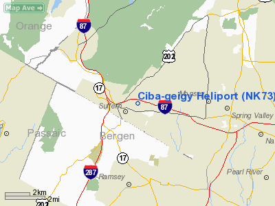
| From nearest city: | 1 nautical miles N of Suffern, NY |
| Location: | Rockland County, NY |
| Magnetic Variation: | 13W (1985) |
Owner & Manager
| Ownership: | Privately owned |
| Owner: | Ciba-geigy, Pharmaceuticals |
| Address: | Old Mill Road
Suffern, NY 10901 |
| Phone number: | 914-357-1700 |
| Manager: | Robert E. Hoarle |
| Address: | Old Mill Road
Suffern, NY 10901 |
| Phone number: | 914-357-1700
EXT 6394 OR 914-357-2450. |
Airport Operations and Facilities
| Airport Use: | Private |
| Segmented Circle: | No |
| Control Tower: | No |
| Landing fee charge: | No |
| Sectional chart: | New York |
| Region: | AEA - Eastern |
| Boundary ARTCC: | ZNY - New York |
| Tie-in FSS: | ISP - New York |
| FSS Toll Free: | 1-800-WX-BRIEF |
Runway Information
Helipad H1
| Dimension: | 100 x 100 ft / 30.5 x 30.5 m |
| Surface: | ASPH, |
| |
Runway H1 |
Runway |
| Traffic Pattern: | Left | Left |
|
Radio Navigation Aids
| ID |
Type |
Name |
Ch |
Freq |
Var |
Dist |
| SKU | FAN MARKER | Stanwyck | | | 12W | 24.9 nm |
| EWR | FAN MARKER | Maryann | | | 11W | 25.1 nm |
| PNJ | NDB | Paterson | | 347.00 | 12W | 10.4 nm |
| SW | NDB | Neely | | 335.00 | 14W | 22.5 nm |
| SKU | NDB | Stanwyck | | 261.00 | 12W | 24.9 nm |
| CAT | NDB | Chatham | | 254.00 | 11W | 26.4 nm |
| PO | NDB | Meier | | 403.00 | 12W | 28.5 nm |
| OGY | NDB | Bridge | | 414.00 | 12W | 35.0 nm |
| BBN | NDB | Babylon | | 275.00 | 14W | 43.4 nm |
| OP | NDB | Old Field Point Light | | 316.00 | 13W | 46.8 nm |
| TEB | VOR/DME | Teterboro | 021X | 108.40 | 11W | 16.5 nm |
| LGA | VOR/DME | La Guardia | 078X | 113.10 | 12W | 23.0 nm |
| CMK | VOR/DME | Carmel | 113X | 116.60 | 12W | 26.8 nm |
| HUO | VOR/DME | Huguenot | 108X | 116.10 | 11W | 27.1 nm |
| CRI | VOR/DME | Canarsie | 070X | 112.30 | 11W | 32.3 nm |
| JFK | VOR/DME | Kennedy | 106X | 115.90 | 12W | 33.5 nm |
| STW | VOR/DME | Stillwater | 033X | 109.60 | 11W | 34.1 nm |
| IGN | VOR/DME | Kingston | 123X | 117.60 | 12W | 35.8 nm |
| BWZ | VOR/DME | Broadway | 089X | 114.20 | 11W | 36.7 nm |
| SBJ | VOR/DME | Solberg | 076X | 112.90 | 10W | 42.4 nm |
| DPK | VOR/DME | Deer Park | 124X | 117.70 | 12W | 42.5 nm |
| BDR | VOR/DME | Bridgeport | 25X | 108.80 | 12W | 45.8 nm |
| PWL | VOR/DME | Pawling | 090X | 114.30 | 12W | 45.9 nm |
| COL | VOR/DME | Colts Neck | 101X | 115.40 | 11W | 48.5 nm |
| SAX | VORTAC | Sparta | 104X | 115.70 | 11W | 18.6 nm |
| JFK | VOT | Kennedy | | 115.10 | | 33.3 nm |
| BDR | VOT | Bridgeport | | 109.25 | | 45.7 nm |
Remarks
- VFR USE ONLY; LIGHT POLE AND TREES NEAR PAD ARE REMOVED, CONTACT GADO-TETERBORO PRIOR TO INITIATING OPERATIONS.
Images and information placed above are from
http://www.airport-data.com/airport/NK73/
We thank them for the data!
| General Info
|
| Country |
United States
|
| State |
NEW YORK
|
| FAA ID |
NK73
|
| Latitude |
41-07-06.344N
|
| Longitude |
074-08-03.518W
|
| Elevation |
310 feet
|
| Near City |
SUFFERN
|
We don't guarantee the information is fresh and accurate. The data may
be wrong or outdated.
For more up-to-date information please refer to other sources.
|
|


