|
|
Chautauqua County/dunkirk Airport |
| Chautauqua County/Dunkirk Airport |
| IATA: DKK – ICAO: KDKK – FAA LID: DKK |
| Summary |
| Airport type |
Public |
| Owner |
Chautauqua County |
| Serves |
Dunkirk, New York |
| Elevation AMSL |
693 ft / 211 m |
| Coordinates |
42°29′36″N 079°16′19″W / 42.49333°N 79.27194°W / 42.49333; -79.27194 |
| Runways |
| Direction |
Length |
Surface |
| ft |
m |
| 6/24 |
5,000 |
1,524 |
Asphalt |
| 15/33 |
4,000 |
1,219 |
Asphalt |
| Statistics (2006) |
| Aircraft operations |
37,548 |
| Based aircraft |
41 |
| Source: Federal Aviation Administration |
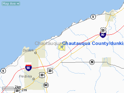
Chautauqua County/Dunkirk Airport (IATA: DKK, ICAO: KDKK, FAA LID: DKK) is a county-owned public-use airport in Chautauqua County, New York, United States. It is located three nautical miles (6 km) east of the central business district of Dunkirk, New York.
Facilities and aircraft
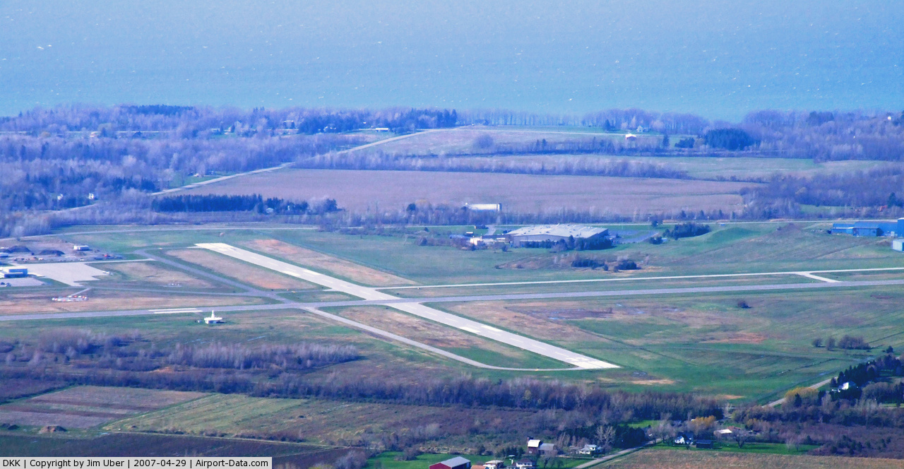
Chautauqua County/Dunkirk Airport covers an area of 450 acres (182 ha) at an elevation of 693 feet (211 m) above mean sea level. It has two asphalt paved runways: 6/24 is 5,000 by 100 feet (1,524 x 30 m) and 15/33 is 4,000 by 100 feet (1,219 x 30 m).
For the 12-month period ending July 19, 2006, the airport had 37,548 aircraft operations, an average of 102 per day: 94% general aviation and 5% air taxi and 1% military. At that time there were 41 aircraft based at this airport: 78% single-engine, 17% multi-engine, 2% jet and 2% helicopter.
The above content comes from Wikipedia and is published under free licenses – click here to read more.
 |
(Click on the photo to enlarge) |
Location & QuickFacts
| FAA Information Effective: | 2008-09-25 |
| Airport Identifier: | DKK |
| Airport Status: | Operational |
| Longitude/Latitude: | 079-16-19.3500W/42-29-36.0070N
-79.272042/42.493335 (Estimated) |
| Elevation: | 693 ft / 211.23 m (Surveyed) |
| Land: | 450 acres |
| From nearest city: | 3 nautical miles E of Dunkirk, NY |
| Location: | Chautauqua County, NY |
| Magnetic Variation: | 07W (1965) |
Owner & Manager
| Ownership: | Publicly owned |
| Owner: | Chaut Co |
| Address: | 3163 Airport Dr
Jamestown, NY 14701 |
| Phone number: | 716-661-8400 |
| Manager: | George Spanos |
| Address: | 3163 Airport Dr
Jamestown, NY 14701 |
| Phone number: | 716-484-0204
ARPT MAINTENANCE DEPT 716-366-0782. |
Airport Operations and Facilities
| Airport Use: | Open to public |
| Wind indicator: | Yes |
| Segmented Circle: | Yes |
| Control Tower: | No |
| Lighting Schedule: | DUSK-DAWN
ACTVT MIRL RYS 06/24 & 15/33, PAPI RYS 06, 24, 15, & 33, & REIL RY 6 & 24 - CTAF. |
| Beacon Color: | Clear-Green (lighted land airport) |
| Landing fee charge: | No |
| Sectional chart: | Detroit |
| Region: | AEA - Eastern |
| Boundary ARTCC: | ZOB - Cleveland |
| Tie-in FSS: | BUF - Buffalo |
| FSS on Airport: | No |
| FSS Toll Free: | 1-800-WX-BRIEF |
| NOTAMs Facility: | DKK (NOTAM-d service avaliable) |
| Federal Agreements: | NGY3 |
Airport Communications
| CTAF: | 123.075 |
| Unicom: | 123.075 |
Airport Services
| Fuel available: | 100LLA |
| Airframe Repair: | MAJOR |
| Power Plant Repair: | MAJOR |
| Bottled Oxygen: | NONE |
| Bulk Oxygen: | NONE |
Runway Information
Runway 06/24
| Dimension: | 5000 x 100 ft / 1524.0 x 30.5 m |
| Surface: | ASPH, Fair Condition |
| Weight Limit: | Single wheel: 25000 lbs. |
| Edge Lights: | Medium |
| |
Runway 06 |
Runway 24 |
| Longitude: | 079-16-41.2400W | 079-15-50.6470W |
| Latitude: | 42-29-21.7920N | 42-29-54.0080N |
| Elevation: | 674.00 ft | 665.00 ft |
| Alignment: | 49 | 127 |
| Traffic Pattern: | Left | Left |
| Markings: | Non-precision instrument, Good Condition | Non-precision instrument, Good Condition |
| Crossing Height: | 0.00 ft | 44.00 ft |
| VASI: | 4-light PAPI on left side | 2-light PAPI on left side |
| Visual Glide Angle: | 3.00° | 3.00° |
| Runway End Identifier: | Yes | Yes |
| Obstruction: | 29 ft trees, 369.0 ft from runway, 275 ft left of centerline, 5:1 slope to clear | 65 ft , 1965.0 ft from runway, 323 ft right of centerline, 27:1 slope to clear |
|
Runway 15/33
| Dimension: | 4000 x 100 ft / 1219.2 x 30.5 m |
| Surface: | ASPH, Good Condition |
| Weight Limit: | Single wheel: 25000 lbs. |
| Edge Lights: | Medium |
| |
Runway 15 |
Runway 33 |
| Longitude: | 079-16-40.9210W | 079-16-06.1280W |
| Latitude: | 42-29-48.7100N | 42-29-18.7620N |
| Elevation: | 661.00 ft | 693.00 ft |
| Alignment: | 127 | 127 |
| Traffic Pattern: | Left | Left |
| Markings: | Non-precision instrument, Good Condition | Non-precision instrument, Good Condition |
| Crossing Height: | 36.00 ft | 45.00 ft |
| VASI: | 4-light PAPI on left side | 4-light PAPI on left side |
| Visual Glide Angle: | 3.00° | 3.10° |
| Obstruction: | 15 ft road, 206.0 ft from runway | 76 ft tree, 654.0 ft from runway, 135 ft left of centerline, 5:1 slope to clear |
|
Radio Navigation Aids
| ID |
Type |
Name |
Ch |
Freq |
Var |
Dist |
| ORJ | NDB | Corry | | 258.00 | 09W | 38.7 nm |
| SN | NDB | St Catherines | | 408.00 | 01E | 39.3 nm |
| CQD | NDB | Cascade | | 372.00 | 08W | 43.3 nm |
| LYS | NDB | Olean | | 360.00 | 09W | 43.5 nm |
| HM | NDB | Hamilton | | 221.00 | 08W | 49.7 nm |
| IAG | TACAN | Niagara Falls | 047X | | 10W | 39.7 nm |
| JHW | VOR/DME | Jamestown | 094X | 114.70 | 07W | 19.5 nm |
| BUF | VOR/DME | Buffalo | 111X | 116.40 | 08W | 38.1 nm |
| DKK | VORTAC | Dunkirk | 109X | 116.20 | 07W | 0.2 nm |
| TDT | VORTAC | Tidioute | 123X | 117.60 | 09W | 47.3 nm |
| BUF | VOT | Buffalo | | 109.00 | | 35.8 nm |
Remarks
- NIGHT SNOW PLOWING NOT AVBL.
- DEER & BIRDS INVOF AIRPORT
- EXISTED PRIOR TO 1959.
Images and information placed above are from
http://www.airport-data.com/airport/DKK/
We thank them for the data!
| General Info
|
| Country |
United States
|
| State |
NEW YORK
|
| FAA ID |
DKK
|
| Latitude |
42-29-36.007N
|
| Longitude |
079-16-19.350W
|
| Elevation |
693 feet
|
| Near City |
DUNKIRK
|
We don't guarantee the information is fresh and accurate. The data may
be wrong or outdated.
For more up-to-date information please refer to other sources.
|
|