 |
|
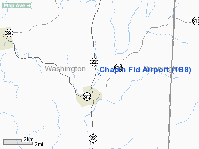
Location & QuickFacts
| FAA Information Effective: | 2008-09-25 |
| Airport Identifier: | 1B8 |
| Airport Status: | Operational |
| Longitude/Latitude: | 073-21-58.4010W/43-03-00.2770N
-73.366223/43.050077 (Estimated) |
| Elevation: | 508 ft / 154.84 m (Estimated) |
| Land: | 14 acres |
| From nearest city: | 2 nautical miles N of Cambridge, NY |
| Location: | Washington County, NY |
| Magnetic Variation: | 14W (1985) |
Owner & Manager
| Ownership: | Privately owned |
| Owner: | Dean Chapin |
| Address: | Po Box 144
Cambridge, NY 12816 |
| Phone number: | 518-677-8082 |
| Manager: | Dick Record |
| Address: | Faile's Dairy
Cambridge, NY 12816 |
| Phone number: | 518-677-3866 |
Airport Operations and Facilities
| Airport Use: | Open to public |
| Wind indicator: | Yes |
| Segmented Circle: | No |
| Control Tower: | No |
| Landing fee charge: | No |
| Sectional chart: | New York |
| Region: | AEA - Eastern |
| Boundary ARTCC: | ZBW - Boston |
| Tie-in FSS: | BTV - Burlington |
| FSS on Airport: | No |
| FSS Toll Free: | 1-800-WX-BRIEF |
| NOTAMs Facility: | BTV (NOTAM-d service avaliable) |
Airport Communications
Airport Services
| Airframe Repair: | MINOR |
| Power Plant Repair: | MINOR |
Runway Information
Runway 05/23
| Dimension: | 2130 x 65 ft / 649.2 x 19.8 m
LENGTH REDUCED ON SOUTH END
WIDTH VARIES FROM 65'-80' BASED ON MOWING |
| Surface: | TURF, Good Condition
& RY 07/25 SOFT & WET MAR-JUN. |
| |
Runway 05 |
Runway 23 |
| Traffic Pattern: | Left | Left |
| Obstruction: | 12 ft crops, 35 ft right of centerline | 80 ft trees, 20.0 ft from runway, 85 ft right of centerline |
|
Runway 07/25
| Dimension: | 2100 x 63 ft / 640.1 x 19.2 m
LENGTH REDUCED ON SOUTH END
WIDTH VARIES FROM 65'-80' BASED ON MOWING |
| Surface: | TURF, Good Condition
& RY 07/25 SOFT & WET MAR-JUN. |
| |
Runway 07 |
Runway 25 |
| Traffic Pattern: | Left | Left |
| Markings: | Nonstandard,
RYS 07 & 25 DSPLCD THLDS MKD WITH STRIPED CYLINDERS. | Nonstandard, |
| Displaced threshold: | 222.00 ft | 306.00 ft |
| Runway End Identifier: | Yes | |
| Obstruction: | 23 ft rr, 10.0 ft from runway, 30 ft right of centerline
0:1 SLOPE TO DISPLACED THRESHOLD | 15 ft road, 1.0 ft from runway
0:1 SLOPE TO DISPLACED THRESHOLD |
|
Radio Navigation Aids
| ID |
Type |
Name |
Ch |
Freq |
Var |
Dist |
| PSF | FAN MARKER | Abyss | | | 13W | 36.4 nm |
| R | FAN MARKER | Chitt | | | 14W | 39.2 nm |
| VWD | NDB | Mount Snow | | 224.00 | 15W | 23.3 nm |
| HEU | NDB | Hunter | | 356.00 | 14W | 27.7 nm |
| DXT | NDB | Dalton | | 370.00 | 15W | 35.9 nm |
| SXD | NDB | Springfield | | 265.00 | 15W | 36.7 nm |
| JJH | NDB | Johnstown | | 523.00 | 14W | 42.6 nm |
| DYO | NDB | Smuto | | 221.00 | 15W | 43.3 nm |
| CNH | NDB | Claremont | | 233.00 | 16W | 47.6 nm |
| IVV | NDB | White River | | 379.00 | 16W | 49.9 nm |
| CAM | VOR/DME | Cambridge | 097X | 115.00 | 14W | 3.5 nm |
| RUT | VOR/DME | Rutland | 47X | 111.00 | 15W | 33.9 nm |
| CTR | VOR/DME | Chester | 098X | 115.10 | 13W | 49.2 nm |
| GFL | VORTAC | Glens Falls | 039X | 110.20 | 14W | 20.6 nm |
| ALB | VORTAC | Albany | 100X | 115.30 | 13W | 26.5 nm |
| EEN | VORTAC | Keene | 031X | 109.40 | 14W | 49.7 nm |
| ALB | VOT | Albany County | | 108.20 | | 27.3 nm |
Remarks
- LGTD 5 FT FENCE AT RY 25 END.
- PRVDD THLDS ARE DSPLCD TO PRVD 20:1 APCH SLOPES.
Images and information placed above are from
http://www.airport-data.com/airport/1B8/
We thank them for the data!
| General Info
|
| Country |
United States
|
| State |
NEW YORK
|
| FAA ID |
1B8
|
| Latitude |
43-03-00.277N
|
| Longitude |
073-21-58.401W
|
| Elevation |
508 feet
|
| Near City |
CAMBRIDGE
|
We don't guarantee the information is fresh and accurate. The data may
be wrong or outdated.
For more up-to-date information please refer to other sources.
|
|


