 |
|
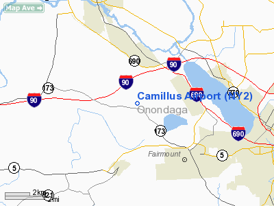
Location & QuickFacts
| FAA Information Effective: | 2008-09-25 |
| Airport Identifier: | NY2 |
| Airport Status: | Operational |
| Longitude/Latitude: | 076-17-33.8000W/43-05-07.0000N
-76.292722/43.085278 (Estimated) |
| Elevation: | 405 ft / 123.44 m (Estimated) |
| Land: | 60 acres |
| From nearest city: | 4 nautical miles N of Camillus, NY |
| Location: | Onondaga County, NY |
| Magnetic Variation: | 12W (1985) |
Owner & Manager
| Ownership: | Privately owned |
| Owner: | Camillus Airport Inc |
| Address: | 3305 Cessna Dr
Warners, NY 13164 |
| Phone number: | 315-488-0094 |
| Manager: | Mike Russ |
| Address: | Po Box 42
Warners, NY 13164 |
| Phone number: | 315-488-0094 |
Airport Operations and Facilities
| Airport Use: | Open to public |
| Wind indicator: | Yes |
| Segmented Circle: | No |
| Control Tower: | No |
| Lighting Schedule: | RDO-CTL
ACTVT ROTG BCN - CTAF. |
| Beacon Color: | Clear-Green (lighted land airport) |
| Sectional chart: | New York |
| Region: | AEA - Eastern |
| Boundary ARTCC: | ZBW - Boston |
| Tie-in FSS: | BUF - Buffalo |
| FSS Toll Free: | 1-800-WX-BRIEF |
| NOTAMs Facility: | BUF (NOTAM-d service avaliable) |
Airport Communications
Airport Services
Runway Information
Runway 10/28
| Dimension: | 3970 x 60 ft / 1210.1 x 18.3 m |
| Surface: | ASPH, Fair Condition |
| Edge Lights: | Non-standard lighting system
NSTD LIRL DUE TO LCTN. |
| |
Runway 10 |
Runway 28 |
| Traffic Pattern: | Left | Left |
| Markings: | Nonstandard, Fair Condition
FADED & IRREGULAR | Nonstandard, Fair Condition
FADED & IRREGULAR |
| Obstruction: | 60 ft trees, 681.0 ft from runway, 60 ft left of centerline, 8:1 slope to clear
RWY 10 : +27' TREE, 52' RT., 58' FRM THLD; +20' BRUSH, 38' LT., 72' FRM THLD; +13' TRAILERS, 77' LT., 26' FRM THLD; +20' BRUSH, 50' RT., 20' FRM THLD. | 25 ft bldg, 211.0 ft from runway, 123 ft right of centerline, 1:1 slope to clear
RWY 28:+25' BLDG., 123' RT., 153' FRM THLD;+78' TREES, 66' LT., 7' FRM THLD. |
|
Radio Navigation Aids
| ID |
Type |
Name |
Ch |
Freq |
Var |
Dist |
| BK | NDB | Plein | | 329.00 | 12W | 36.5 nm |
| PYA | NDB | Penn Yan | | 260.00 | 12W | 42.8 nm |
| CJY | NDB | Clay | | 275.00 | 12W | 45.2 nm |
| GSS | TACAN | Griffiss | 057X | | 12W | 39.6 nm |
| ITH | VOR/DME | Ithaca | 055X | 111.80 | 10W | 36.2 nm |
| SYR | VORTAC | Syracuse | 117X | 117.00 | 11W | 6.0 nm |
| GGT | VORTAC | Georgetown | 125X | 117.80 | 11W | 27.2 nm |
| UCA | VORTAC | Utica | 049X | 111.20 | 12W | 49.7 nm |
Remarks
- RY 10/28 TERRAIN DROPS OFF 3 TO 4 FT ALONG BOTH SIDES OF RY ON WEST END.
- HELIPAD LOCATED JUST NORTHEAST OF RWY 28 THLD
- OBSTRUCTIONS PENETRATE LATERAL PRIMARY SURFACE: RWY 10: +50'-70' TREES, 93' NORTH OF RWY CNTRLN, 450'-1060' PAST BEG. OF RWY; ; +13' TRAILERS, 57' NORTH OF CNTRLN, 30'-270' PAST RWY BEG. RWY 28: +10' PLANES, 63' NORTH OF CNTRLN., 300'-575' PAST RWY BEG.; LOGS, 60' NORTH OF CNTRLN, 7
- VFR USE ONLY.
Images and information placed above are from
http://www.airport-data.com/airport/NY2/
We thank them for the data!
| General Info
|
| Country |
United States
|
| State |
NEW YORK
|
| FAA ID |
NY2
|
| Latitude |
43-05-00.240N
|
| Longitude |
076-16-58.744W
|
| Elevation |
405 feet
|
| Near City |
CAMILLUS
|
We don't guarantee the information is fresh and accurate. The data may
be wrong or outdated.
For more up-to-date information please refer to other sources.
|
|


