|
 |
|
||||
|
Main building
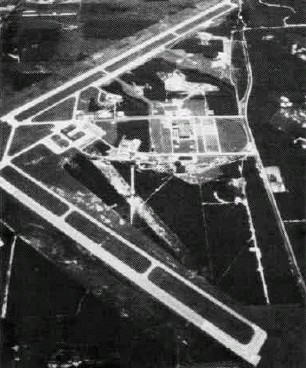
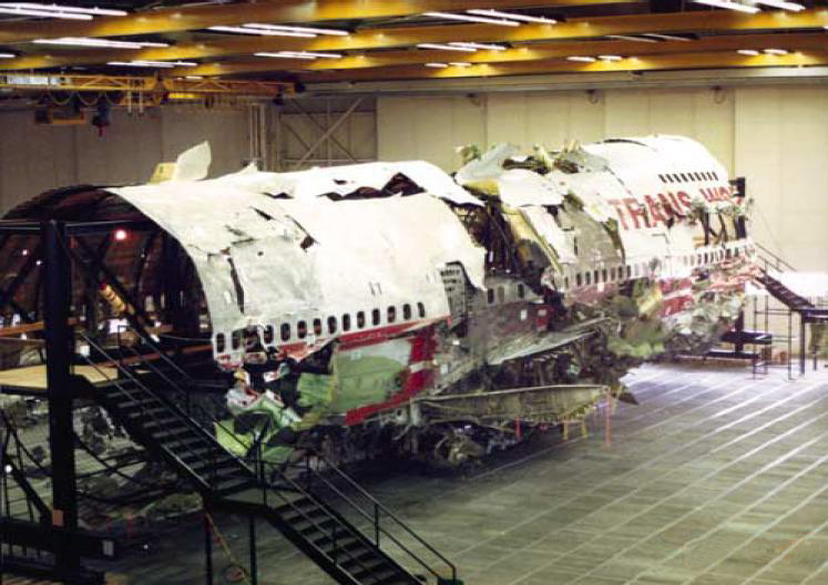
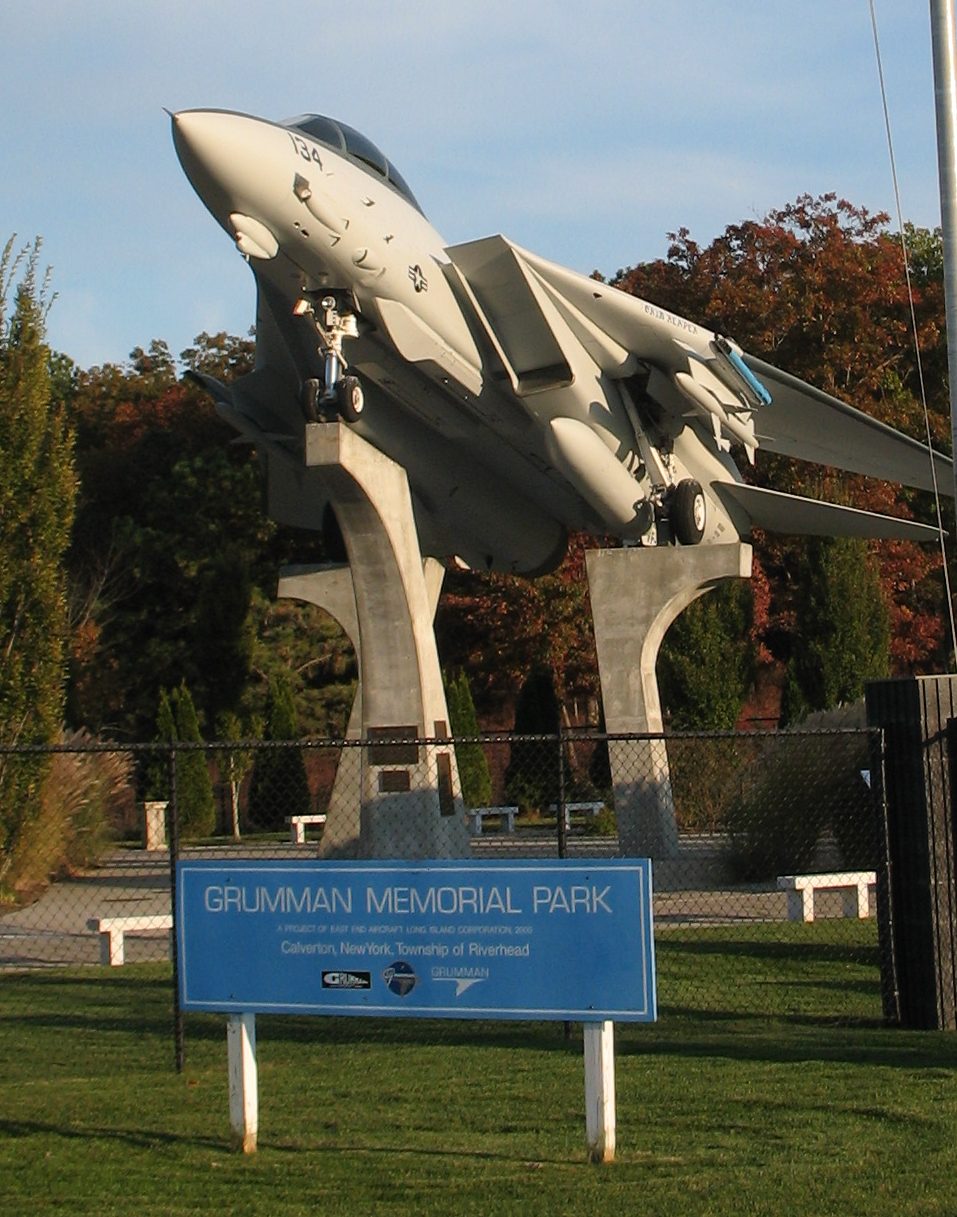
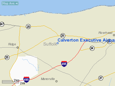
Calverton Executive Airpark (IATA: CTO, FAA LID: 3C8, formerly CTO) is a public-owned private-use airport located three miles (5 km) west of the central business district of the Calverton hamlet, in the Town of Riverhead, Suffolk County, New York, United States. It is owned by the Town of Riverhead. It was formerly the Naval Weapons Industrial Reserve Plant which was owned by the United States Navy and used to assemble, test, refit and retrofit jets built by the Grumman Corporation on Long Island. The airport covers an area of 2,921 acres (11.8 km) which contains two asphalt and concrete runways: 14/32 measuring 10,000 x 200 feet (3,048 x 61 m) and 5/23 measuring 7,000 x 200 feet (2,133 x 61 m). Older aerial photographs show both runways marked with Xs which indicate they are closed. More recent photographs show runway 14/32 with the Xs removed and that runway is operational according to the town's airport rules and regulations. The airport is lightly used with most planes using the nearby Francis S. Gabreski Airport. Its most visible commercial air tenant is Sky Dive Long Island which since 2000 has been using the airport for its skydiving operations. HistoryIn 1956 the United States Navy purchased about 6,000 acres (24 km) on the Peconic River by New York Route 25 for the facility. Among the properties purchased was a mansion belonging to the grandson of F.W. Woolworth. The Navy was to build among other things a 10,000-foot (3,000 m) runway. It is labeled on topographic maps as Grumman Peconic River Airport with an FAA code of CTO. The unit is most associated with test, assembly and retrofitting the F-14 Tomcat. The Panther, Cougar, Tiger, and Intruder were also tested at the facility. The Grumman site consisted of "Plant Six," where final assembly of F-14s, A-6s, EA-6Bs, and E-2Cs, and "Plant Seven," Flight Test. During the Space Race Grumman built a mock up of the lunar surface to test its proposed Lunar Roving Vehicle. Many of the lunar astronauts were said to have visited the plant then. In 1965 New York Governor Nelson Rockefeller proposed converting the airport into the fourth New York City metropolitan airport joining Laguardia Airport, John F. Kennedy Airport and Newark Airport. The proposal was abandoned following opposition from both Grumman and local residents. In 1974 when the two other National Cemeteries on Long Island (Cypress Hills National Cemetery and Long Island National Cemetery) were running out of space, the Navy was approached about donating its undeveloped land north of Route 25 for a cemetery. On December 7, 1977, a 902 acres (3.7 km) tract was donated to form Calverton National Cemetery. More land would be donated by the Navy in 2000 bringing the total to 1,045 acres (4.2 km) making it the largest national cemetery in the United States (and also the busiest). In 1996 the wreckage of TWA Flight 800 which had crashed about 20 miles (32 km) south of the airport was reconstructed in a hangar. Grumman had merged with Northrop in 1994 and the new firm eliminated almost all operations on Long Island. Grumman vacated the site on February 14, 1996. In September 1998, the bulk of the developed land, 2,640 acres (10.7 km), at the airport was donated to Riverhead. Another 2,935 acres (11.9 km) was donated to the New York Department of Environmental Conservation for wildlife management. In the 1998 transactions East End Aircraft Long Island Corporation was given 10 acres (40,000 m) on Highway 25 which it is developing into the Grumman Memorial Park and Aerospace Museum. As of January 2006, the Navy still owns 358 acres (mostly areas requiring environment clean up) at the site. Future
The airport's aviation days are numbered. Through 2007, debates raged whether to turn the space into a mega complex around a NASCAR track called EPCAL Centre or a giant ski resort based construction of an artificial 350-foot (110 m) high indoor ski mountain. In January 2008 the Riverhead Town Board with newly elected officers signed a deal to sell the airport for $155 million to Riverhead Resorts to build the multi-facted resort. It will take up to three years to get the necessary environmental permits and the proposed opening date of the project is 2012. A portion of the facility, including the industrial core, is also being developed as an industrial/office park. On February 11, 2010 it was announced that the dormant railway track into the site would be reactivated for freight service. According to Railway Age magazine, Riverhead’s town board awarded a $3.49 million contract to Railroad Construction Co., of Paterson, New Jersey, to activate a rail spur off of the Long Island Rail Road's Main Line out to Greenport, for New York & Atlantic Railway freight trains. The project is being paid largely through federal stimulus funding. Ecology and Endangered SpeciesThe EPCAL site contains the largest remaining grassland on Long Island. The site provides documented breeding and/or foraging habitat for numerous grassland birds, including at least one New York State Endangered Species (i.e., short-eared owl) and five New York State Species of Special Concern (i.e., common nighthawk, grasshopper sparrow, vesper sparrow, horned lark, and whip-poor-will). In fact, these grasslands are the most productive breeding grounds for grasshopper sparrow (a NYS Species of Special Concern) in all of New York State. The EPCAL site contains 10 kettle hole ponds which are documented breeding sites for the Eastern tiger salamander, a New York State Endangered Species. The site also contains five additional reptile and amphibian species which are identified as Species of Special Concern in New York State (i.e., marbled salamander, Eastern spadefoot, spotted turtle, Eastern box turtle, and Eastern hognose snake). A total of 24 amphibian and reptile species have been identified on or near the EPCAL property. As discussions over whether the airport could be developed the New York State Department of Environmental Conservation announced in February 2008 that endangered Short-eared Owls and Northern Harriers had been spotted at the airport which would prompt the DEC to make the ultimate decision the environmental impact of the development. The above content comes from Wikipedia and is published under free licenses – click here to read more.
Location & QuickFacts
Owner & Manager
Airport Operations and Facilities
Airport Services
Runway InformationRunway 14/32
Radio Navigation Aids
Remarks
Images and information placed above are from We thank them for the data!
We don't guarantee the information is fresh and accurate. The data may
be wrong or outdated.
|
|||||||||||||||||||||||||||||||||||||||||||||||||||||||||||||||||||||||||||||||||||||||||||||||||||||||||||||||||||||||||||||||||||||||||||||||||||||||||||||||||||||||||||||||||||||||||||||||||||||||||||||||||||||||||||||||||||||||||||||||||||||||||||||||||||||||||||||||||||||||||||||||||||||||||||||||||||||||||||||||||||||||||||||||||||||||||||||||||||||||||||||||||

 |
|
Copyright 2004-2026 © by Airports-Worldwide.com, Vyshenskoho st. 36, Lviv 79010, Ukraine Legal Disclaimer |