 |
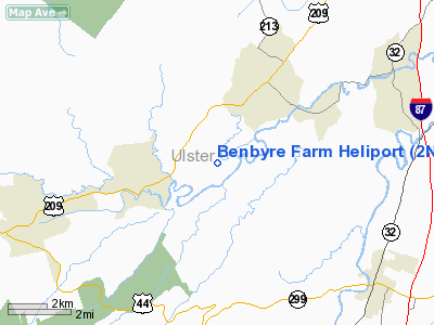
|
Location & QuickFacts
| FAA Information Effective: | 2008-09-25 |
| Airport Identifier: | 2NY8 |
| Airport Status: | Operational |
| Longitude/Latitude: | 074-10-58.5250W/41-48-12.3350N
-74.182924/41.803426 (Estimated) |
| Elevation: | 260 ft / 79.25 m (Estimated) |
| Land: | 0 acres |
| From nearest city: | 1 nautical miles NW of Alligerville, NY |
| Location: | Ulster County, NY |
| Magnetic Variation: | 13W (1985) |
Owner & Manager
| Ownership: | Privately owned |
| Owner: | Alan R. Bendelius |
| Address: | Rd 2, Box 149
Accord, NY 12404 |
| Phone number: | 914-687-9062 |
| Manager: | Alan R. Bendelius |
| Address: |
|
Airport Operations and Facilities
| Airport Use: | Private |
| Wind indicator: | No |
| Segmented Circle: | No |
| Control Tower: | No |
| Landing fee charge: | No |
| Sectional chart: | New York |
| Region: | AEA - Eastern |
| Boundary ARTCC: | ZBW - Boston |
| Tie-in FSS: | ISP - New York |
| FSS on Airport: | No |
| FSS Toll Free: | 1-800-WX-BRIEF |
Runway Information
Helipad H1
| Dimension: | 800 x 200 ft / 243.8 x 61.0 m |
| Surface: | TURF, |
| |
Runway H1 |
Runway |
| Traffic Pattern: | Left | Left |
|
Radio Navigation Aids
| ID |
Type |
Name |
Ch |
Freq |
Var |
Dist |
| SKU | FAN MARKER | Stanwyck | | | 12W | 17.7 nm |
| GBR | FAN MARKER | Sheffield | | | 13W | 41.5 nm |
| PO | NDB | Meier | | 403.00 | 12W | 16.9 nm |
| SKU | NDB | Stanwyck | | 261.00 | 12W | 17.7 nm |
| SW | NDB | Neely | | 335.00 | 14W | 19.2 nm |
| MS | NDB | Monga | | 359.00 | 12W | 30.5 nm |
| PFH | NDB | Philmont | | 272.00 | 13W | 33.9 nm |
| GBR | NDB | Great Barrington | | 395.00 | 14W | 41.6 nm |
| TBY | NDB | Waterbury | | 257.00 | 14W | 49.5 nm |
| IGN | VOR/DME | Kingston | 123X | 117.60 | 12W | 18.2 nm |
| PWL | VOR/DME | Pawling | 090X | 114.30 | 12W | 26.2 nm |
| HUO | VOR/DME | Huguenot | 108X | 116.10 | 11W | 30.0 nm |
| DNY | VOR/DME | De Lancey | 058X | 112.10 | 11W | 41.3 nm |
| CMK | VOR/DME | Carmel | 113X | 116.60 | 12W | 41.5 nm |
| SAX | VORTAC | Sparta | 104X | 115.70 | 11W | 47.0 nm |
Images and information placed above are from
http://www.airport-data.com/airport/2NY8/
We thank them for the data!
| General Info
|
| Country |
United States
|
| State |
NEW YORK
|
| FAA ID |
2NY8
|
| Latitude |
41-48-12.335N
|
| Longitude |
074-10-58.525W
|
| Elevation |
260 feet
|
| Near City |
ALLIGERVILLE
|
We don't guarantee the information is fresh and accurate. The data may
be wrong or outdated.
For more up-to-date information please refer to other sources.
|
|


