 |
|
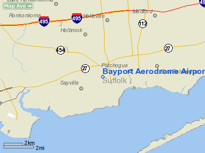
Bayport Aerodrome Airport |
| Bayport Aerodrome |
| IATA: none – ICAO: none – FAA LID: 23N |
| Summary |
| Airport type |
Public/Antique |
| Owner |
Town of Islip |
| Location |
Bayport, New York |
| Elevation AMSL |
41 ft / 12(estimated) m |
| Coordinates |
40°45′30.3″N 73°03′13.4″W / 40.758417°N 73.053722°W / 40.758417; -73.053722Coordinates: 40°45′30.3″N 73°03′13.4″W / 40.758417°N 73.053722°W / 40.758417; -73.053722 |
| Website |
Bayport Aerodrome Society |
| Runways |
| Direction |
Length |
Surface |
| ft |
m |
| 18/36 |
2740 |
835 |
Grass |
|
| Davis Field |
| U.S. National Register of Historic Places |
| U.S. Historic District |
|
| Location: |
2nd St. & 3rd Ave., Bayport, New York |
| Area: |
59.9 acres (24.2 ha) |
| Built/Founded: |
1945 |
| Architect: |
Davis, Curtis, Sr. |
| Governing body: |
Local |
| Added to NRHP: |
January 22, 2008 |
| NRHP Reference#: |
07001456 |
|
Bayport Aerodrome (FAA LID: 23N) (formerly known as Davis Field) is a historic rural airport one mile northwest of Bayport, New York. The airport has a grass runway and is owned by the Town of Islip. It is managed by a non-profit organization that specializes in antique airplanes, known as the Bayport Aerodrome Society, which was established in 1972.
Bayport Aerodrome is not used for commercial aviation, such as the nearby Long Island MacArthur Airport. The airport has been listed on the National Register of Historic Places as a national historic district since January 22, 2008.
The above content comes from Wikipedia and is published under free licenses – click here to read more.
Location & QuickFacts
| FAA Information Effective: | 2008-09-25 |
| Airport Identifier: | 23N |
| Airport Status: | Operational |
| Longitude/Latitude: | 073-03-13.3950W/40-45-30.3530N
-73.053721/40.758431 (Estimated) |
| Elevation: | 41 ft / 12.50 m (Estimated) |
| Land: | 50 acres |
| From nearest city: | 1 nautical miles NW of Bayport, NY |
| Location: | Suffolk County, NY |
| Magnetic Variation: | 13W (1985) |
Owner & Manager
| Ownership: | Publicly owned |
| Owner: | Town Of Islip |
| Address: | 2nd Ave
Bayport, NY 11705 |
| Phone number: | 631-467-3300 |
| Manager: | Alfred Werner, Commissioner |
| Address: | 100 Arrival Ave, Suite 100
Ronkonkoma, NY 11779 |
| Phone number: | 631-467-3300 |
Airport Operations and Facilities
| Airport Use: | Open to public |
| Wind indicator: | Yes |
| Segmented Circle: | Yes |
| Control Tower: | No |
| Landing fee charge: | No |
| Sectional chart: | New York |
| Region: | AEA - Eastern |
| Traffic Pattern Alt: | 600 ft |
| Boundary ARTCC: | ZBW - Boston |
| Responsible ARTCC: | ZNY - New York |
| Tie-in FSS: | ISP - New York |
| FSS on Airport: | No |
| FSS Toll Free: | 1-800-WX-BRIEF |
| NOTAMs Facility: | ISP (NOTAM-d service avaliable) |
| Federal Agreements: | NGY |
Airport Communications
| CTAF: | 122.700 |
| Unicom: | 122.700 |
Airport Services
| Bottled Oxygen: | NONE |
| Bulk Oxygen: | NONE |
Runway Information
Runway 18/36
| Dimension: | 2740 x 150 ft / 835.2 x 45.7 m
RY 18/36, EAST 75' WIDTH CLSD OCT-APRIL; WEST 75' WIDTH CLSD MAY-SEPT. |
| Surface: | TURF, Good Condition |
| |
Runway 18 |
Runway 36 |
| Traffic Pattern: | Right | Left |
| Crossing Height: | 0.00 ft | 20.00 ft |
| Displaced threshold: | 0.00 ft | 550.00 ft
RY 36 THRLD MARKED WITH 1 FT WIDE APRON AND 2 FT WIDE THRD (WHITE) BOTH MADE WITH CONC BLOCKS FLUSH WITH TURF SURFACE. |
| VASI: | | system of panels on right side that may or may not be lighted |
| Visual Glide Angle: | 0.00° | 5.00° |
| Obstruction: | 37 ft trees, 380.0 ft from runway, 10:1 slope to clear | 44 ft trees, 37.0 ft from runway
RWY 36 APCH RATIO 12:1 TO DSPLCD THLD. |
|
Radio Navigation Aids
| ID |
Type |
Name |
Ch |
Freq |
Var |
Dist |
| OP | NDB | Old Field Point Light | | 316.00 | 13W | 13.5 nm |
| BBN | NDB | Babylon | | 275.00 | 14W | 15.9 nm |
| OGY | NDB | Bridge | | 414.00 | 12W | 39.5 nm |
| MMK | NDB | Meriden | | 238.00 | 14W | 46.3 nm |
| TBY | NDB | Waterbury | | 257.00 | 14W | 46.5 nm |
| FOK | TACAN | Suffolk Co | 047X | | 13W | 19.8 nm |
| DPK | VOR/DME | Deer Park | 124X | 117.70 | 12W | 11.6 nm |
| CCC | VOR/DME | Calverton | 119X | 117.20 | 13W | 15.5 nm |
| BDR | VOR/DME | Bridgeport | 25X | 108.80 | 12W | 24.4 nm |
| HVN | VOR/DME | New Haven | 035X | 109.80 | 13W | 31.2 nm |
| JFK | VOR/DME | Kennedy | 106X | 115.90 | 12W | 33.6 nm |
| MAD | VOR/DME | Madison | 041X | 110.40 | 13W | 37.2 nm |
| LGA | VOR/DME | La Guardia | 078X | 113.10 | 12W | 37.5 nm |
| CRI | VOR/DME | Canarsie | 070X | 112.30 | 11W | 39.3 nm |
| CMK | VOR/DME | Carmel | 113X | 116.60 | 12W | 39.4 nm |
| TEB | VOR/DME | Teterboro | 021X | 108.40 | 11W | 46.2 nm |
| HTO | VORTAC | Hampton | 083X | 113.60 | 13W | 34.9 nm |
| ISP | VOT | Long Island Mac Arthur | | 109.40 | | 2.6 nm |
| BDR | VOT | Bridgeport | | 109.25 | | 24.4 nm |
| JFK | VOT | Kennedy | | 115.10 | | 33.9 nm |
Remarks
- ALL TFC ENTER 45 DEG LEFT BASE FOR RWY36 AT 600 MSL DUE HEAVY JET TFC RWY 33L AT ISP. ALL TFC ENTER 45 DEG RIGHT. DOWNWIND RWY 18 OVER LAKES AT 600 MSL DUE HEAVY JET TFC LNDG RWY 33L AT ISP.
- ALL DOWNWIND SPACING FOR RWY 18/36 S/B OVER LAKES FOR NOISE ABATEMENT.
- PHONE AT ARPT 631-472-4747.
- NO CLSD TFC PATTERN OR TOUCH AND GO LNDGS.
- ARPT CLSD 30 MIN AFTER SS TIL 30 MIN BEFORE SR.
Images and information placed above are from
http://www.airport-data.com/airport/23N/
We thank them for the data!
| General Info
|
| Country |
United States
|
| State |
NEW YORK
|
| FAA ID |
23N
|
| Latitude |
40-45-30.353N
|
| Longitude |
073-03-13.395W
|
| Elevation |
41 feet
|
| Near City |
BAYPORT
|
We don't guarantee the information is fresh and accurate. The data may
be wrong or outdated.
For more up-to-date information please refer to other sources.
|
|


