 |
|
Location & QuickFacts
| FAA Information Effective: | 2008-09-25 |
| Airport Identifier: | NY00 |
| Airport Status: | Operational |
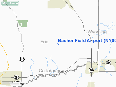
| Longitude/Latitude: | 078-33-22.0810W/42-34-00.2220N
-78.556134/42.566728 (Estimated) |
| Elevation: | 1855 ft / 565.40 m (Estimated) |
| Land: | 47 acres |
| From nearest city: | 3 nautical miles NW of Sardinia, NY |
| Location: | Erie County, NY |
| Magnetic Variation: | 10W (1985) |
Owner & Manager
| Ownership: | Privately owned |
| Owner: | Michael & Barbara Basher |
| Address: | 11420 Warner Gulf Road
E. Concord, NY 14055 |
| Phone number: | 716-496-6044 |
| Manager: | Barbara Basher |
| Address: | 11420 Warner Gulf Road
E. Concord, NY 14055 |
| Phone number: | 716-496-6044 |
Airport Operations and Facilities
| Airport Use: | Private |
| Wind indicator: | Yes |
| Segmented Circle: | No |
| Control Tower: | No |
| Landing fee charge: | No |
| Sectional chart: | Detroit |
| Region: | AEA - Eastern |
| Boundary ARTCC: | ZOB - Cleveland |
| Tie-in FSS: | BUF - Buffalo |
| FSS on Airport: | No |
| FSS Toll Free: | 1-800-WX-BRIEF |
Airport Services
| Airframe Repair: | NONE |
| Power Plant Repair: | NONE |
Runway Information
Runway 10/28
| Dimension: | 1600 x 75 ft / 487.7 x 22.9 m |
| Surface: | TURF, Fair Condition |
| |
Runway 10 |
Runway 28 |
| Traffic Pattern: | Left | Left |
| Obstruction: | 68 ft trees, 75 ft left of centerline, 1:1 slope to clear | 29 ft tree, 0.0 ft from runway, 125 ft right of centerline, 1:1 slope to clear |
|
Radio Navigation Aids
| ID |
Type |
Name |
Ch |
Freq |
Var |
Dist |
| LYS | NDB | Olean | | 360.00 | 09W | 19.7 nm |
| EL | NDB | Halos | | 269.00 | 09W | 39.6 nm |
| AVN | NDB | Avon | | 344.00 | 09W | 43.8 nm |
| SN | NDB | St Catherines | | 408.00 | 01E | 46.5 nm |
| IAG | TACAN | Niagara Falls | 047X | | 10W | 37.3 nm |
| BUF | VOR/DME | Buffalo | 111X | 116.40 | 08W | 22.1 nm |
| JHW | VOR/DME | Jamestown | 094X | 114.70 | 07W | 33.9 nm |
| GEE | VOR/DME | Geneseo | 019X | 108.20 | 09W | 39.8 nm |
| BFD | VOR/DME | Bradford | 113X | 116.60 | 07W | 47.0 nm |
| DKK | VORTAC | Dunkirk | 109X | 116.20 | 07W | 32.1 nm |
| ELZ | VORTAC | Wellsville | 051X | 111.40 | 09W | 37.9 nm |
| BUF | VOT | Buffalo | | 109.00 | | 23.7 nm |
Remarks
- CLOSED WINTERS.
- VFR ONLY.
Images and information placed above are from
http://www.airport-data.com/airport/NY00/
We thank them for the data!
| General Info
|
| Country |
United States
|
| State |
NEW YORK
|
| FAA ID |
NY00
|
| Latitude |
42-34-00.222N
|
| Longitude |
078-33-22.081W
|
| Elevation |
1855 feet
|
| Near City |
SARDINIA
|
We don't guarantee the information is fresh and accurate. The data may
be wrong or outdated.
For more up-to-date information please refer to other sources.
|
|


